This item has been sold, but you can get on the Waitlist to be notified if another example becomes available, or purchase a digital scan.
1870 Neumann Satirical Map of Europe
KarteEuropa-neumann-1870$1,000.00

Title
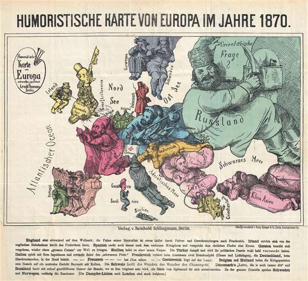
Humoristische Karte von Europa im Jahre 1870.
1870 (dated) 14 x 16 in (35.56 x 40.64 cm) 1 : 11030000
1870 (dated) 14 x 16 in (35.56 x 40.64 cm) 1 : 11030000
Description
This is an extremely rare 1870 German satirical map of Europe by Arnold Neumann. This map presents Europe allegorically, personifying each country, and uses current events to shape their images. The colors on the map do a fantastic job of helping the viewer distinguish between the countries and creates a playful tone to go along with the text at the bottom of the map. The text, summarized, says:
This map was most likely in response to Paul Hadol's French perspective satirical map released earlier in the same year. 1870 was a tense year in Europe. France lost the Franco-Prussian War, which resulted in humiliation for France and a unified Germany. This conflict - which only lasted three months and resulted in the French loss of the provinces of Alsace and Lorraine - laid the groundwork for the major conflicts of the 20th century, World War I and World War II. The following is a translation of the German text at the bottom of the map:
- England, sitting off on their island, is waving a white flag in neutrality, although their neutrality is questionable, since they are sending arms to France.
- Ireland is being held on a string by England, and hopes to one day sever those ties.
- France has lost Alsace and Lorraine, which are being held by Germany.
- Corsica homes one day to again give birth to a 'Great Corsican'.
- Italy plays cards with Rome and loses
- Switzerland heals the wounded
- Belgium and Holland invite the warring parties for a visit while holding bayonets.
- Denmark says, 'My dear, he is still there'. Russia is sitting back and waiting, with a sharpened knife, until they have the opportunity to slice off a piece of the Crescent (Ottoman Empire) for themselves.
- For the time being, Sweden and Norway just sit and watch.
This map was most likely in response to Paul Hadol's French perspective satirical map released earlier in the same year. 1870 was a tense year in Europe. France lost the Franco-Prussian War, which resulted in humiliation for France and a unified Germany. This conflict - which only lasted three months and resulted in the French loss of the provinces of Alsace and Lorraine - laid the groundwork for the major conflicts of the 20th century, World War I and World War II. The following is a translation of the German text at the bottom of the map:
England sits, waiting, on a bag of wool; his flag of neutrality is somewhat tattered from powder and arms shipments to France. Ireland would like to free himself from the English umbilical cord by the Fenian group. Spain is still searching for the lost kingdom and promises the crown to the honest finder. Corsica futilely endeavors to again give birth to a 'Great Corsican'. Sicily issues an invitation to a new vesper. Turkey puffs away and will soon have smoked away her political existence. Italy plays cards (Impatience = Patience in German = similar to Gin Rummy) with Rome and draws the losing card (the 'old maid' or Black Peter card). France loses two shirttails (Alsace and Lorraine), which Germany keeps in his hands while playing Haschemann (a child’s game). --Prussia ---has him already--- Austria lies in wait; Belgium and Holland invite the warring parties to a visit with a neutral dish of bayonets with pistons/ears of corn (play on words probably). Switzerland heals the wounds from the Wonder of Chassepot (a new military rifle). Denmark’s 'My dear, he is still there' and Russia is sitting back and biding his time with a sharpened knife, when he will have the opportunity to slice off a piece of the Crescent for himself. For the time being, Sweden and Norway play the onlookers in this comedy. (The steam ships cruise lines are well travelled to London). Drafted and drawn by Arnold Neumann, Berlin; Publisher Reinhold Schlingmann, Berlin; Schnellpressendruck v. Georg Schreyer & Co. Berlin, Kommandanten-Str.'The following is a transcription of the German text.
England sitzt abwartend auf dem Wollsack; die Fahne seiner Neutralität ist etwas laidirt durch Pulver- und Gewehrsendungen nach Frankreich. Irland möchte sich von der englischen Nabelschnur durch das Fenierthum lösen. Spanien sucht noch immer nach dem verlornen Königthum und verspricht dem ehrlichen Finder eine Krone. Corsica bemüht sich vergebens, wieder einen 'grossen Corsen' zur Welt zu bringen. Sicilien ladet zu eine neuen Vesper. Die Türkei dampft und wird ihr politisches Dasein wohl bald verraucht haben. Italien spielt mit Rom Impatiance und erwischt dabei den 'schwarzen Peter'. Frankreich verliert beim Ausreissen zwei Hemdenzipfel (Elsass und Lothringen), die Deutschland, beim Haschemännchen, in der Hand behält. -- Preussen -- hat Ihm schon -- Oesterreich liegt auf der Lauer; Belgien und Holland laden die Kriegsparteien zum Besuch auf ein neutrales Gericht Bayonett mit Kolben. Die Schweiz heilt die Wunden der wunder des Chassepots. Dänemark's 'Leiwe, die is noch immer döt' und Russland harrt mit scharf geschliffenem Messer der Stunde, wo es ihm vergönnt sein wird, ein Stück vom Halbmond für sich abzuschneiden. Zu der Comödie spielen Schweden und Norwegen vorlaufig die Zuschauer. (Die Dampfer-Linien nach London sind stark befahren.)' Sonstige Angaben: 'Humoristische Karte von Europa entworfen und gezeichnet von Arnold Neumann, Berlin'; 'Verlag. v. Reinhold Schlingmann, Berlin'; 'Schnellpressendruck v. Georg Schreyer & Co. Berlin, Kommandanten-Str.'This map was drafted and drawn by Arnold Neumann, Berlin and published by Reinhold Schlingmann, Berlin. We could find very few examples of this map in institutional collections and no other examples currently on the market.
Condition
Very good. Minor wear along original fold lines. Blank on verso. Lower left margin extended.