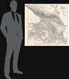
1854 Kiepert Map of the Caucasus, Armenia, Kurdistan, and Azerbaijan
KaukasusLander-kiepert-1854$1,000.00

Title
Karte der Kaukasus - Länder und der Angränzenden Türkischen und Persischen Provinzen Armenien, Kurdistan, und Azerbeidjan.
1854 (dated) 30.5 x 29.25 in (77.47 x 74.295 cm) 1 : 1500000
1854 (dated) 30.5 x 29.25 in (77.47 x 74.295 cm) 1 : 1500000
Description
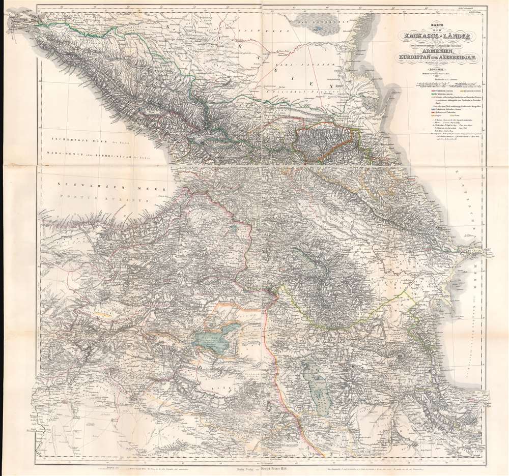
This is an 1854 map of the Caucasus, published during the Caucasian War (1817 - 1864) and the Crimean War (1853 - 1856) by Heinrich Kiepert, the most accomplished 19th-century cartographer working in the Caucasus and Trans-Caucasus. For 50 years, this served as a definitive map used for treaty negotiation, military activity, and administration.
The outbreak of the Crimean War (1853-1856) led to a temporary ceasefire in the Caucasus, as Russians pulled back their forces to defend Tsardom's primary warm water port - Sebastopol. It is not surprising that Kiepert's map appeared in 1854. The end of hostilities can only have fostered optimism in the Caucasian nations. Additionally, the involvement of Western European powers in the Crimean War raised some hope that the interests of the Caucasian peoples might also be equally supported.
The peace did not last. The Crimean War ended in 1856, and fighting immediately resumed in the Caucasus. The Caucasian War gradually wound down as Russian numbers overwhelmed the hearty mountain people, either forcing them into subjugation, slaughtering them, or simply driving them from their ancestral lands. By 1864, the fighting ended, and the Russian Empire took suzerainty over the greater part of the Caucasia.
A Closer Look
The map highlights territory claimed by the Turkish (pink), Persian (yellow), and Russian (green) Empires. Other highlighted entities include Kurdish and Lurian principalities dependent upon Ottoman and Persian protection and other independent Caucasian mountain peoples. The Circassians, Kabardians, and Suanen are marked by blue, Abkhazia and Chechnya by red, and Lesgier and Ossen by yellow.Historical Context
This map appeared during a rare time of relative peace in Caucasia. The Russians repeatedly invaded the Caucasus from about 1817, a series of invasions collectively known as the Caucasian War. There was a brief respite between 1825 and 1833 when the Russian Empire was distracted by wars with Turkey (1828-1829) and Persia (1826-1828), but fighting resumed in earnest in 1833. The mid to late 1830s were witness to the most horrific events - the Caucasian Genocide, which took a heavy toll on the Circassian nation and largely drove its people into exile in Turkey and Persia.The outbreak of the Crimean War (1853-1856) led to a temporary ceasefire in the Caucasus, as Russians pulled back their forces to defend Tsardom's primary warm water port - Sebastopol. It is not surprising that Kiepert's map appeared in 1854. The end of hostilities can only have fostered optimism in the Caucasian nations. Additionally, the involvement of Western European powers in the Crimean War raised some hope that the interests of the Caucasian peoples might also be equally supported.
The peace did not last. The Crimean War ended in 1856, and fighting immediately resumed in the Caucasus. The Caucasian War gradually wound down as Russian numbers overwhelmed the hearty mountain people, either forcing them into subjugation, slaughtering them, or simply driving them from their ancestral lands. By 1864, the fighting ended, and the Russian Empire took suzerainty over the greater part of the Caucasia.
Significance
This map is significant and, for 50 years, was the definitive map of the region, used for treaty negotiation, military activity, and administration. Kiepert traveled the region many times (constantly sketching maps) and produced several major maps of the Ottoman world, including this one. His own observations were supplemented by his diligent scholarship, resulting in a profound understanding of the history of explorers in the same area. Throughout this map, the tracks of earlier travelers are noted and dated. The result is the finest map of the region available for most of the second half of the 19th century. The densely hachured topography on the map testifies to the monumental difficulty of surveying in the region and the greatness of Kiepert's achievement. This map was so authoritative that it became the standard for any serious effort to understand the region. Not only was it relied upon by travelers, archaeologists, and administrators, but it was also consulted to establish new imperial borders following the 1877-78 Russo-Turkish War.Publication History and Census
This map was created by Heinrich Kiepert and published by Dietrich Reimer in 1854. An example is part of the collection at Harvard University.CartographerS
Heinrich Kiepert (July 31, 1818 - April 21, 1899) was a German cartographer and historian active in the mid to late 19th century. Kiepert was born into generous circumstances that allowed him to develop his childhood interest in geography and history into a serious profession. The Berlin-born Kiepert traveled widely in his youth, and was encouraged in his studies by the historian Leopold von Ranke, a family friend. He was a student of classical antiquity under August Meineke and worked with Cal Ritter. He studied history, philology, and geography at the Humboldt University of Berlin - he would eventually teach geography there, and would remain there until his death. Disappointed with the poor quality of maps in historical school books, Kiepert set out to correct the problem. His first major work, the Atlas von Hellas und den hellenischen Kolonien, was published with Karl Ritter in 1840. The work immediately won accolades from the academic community. A number of similar publications followed, including the 1848 Historisch-geographischer Atlas der alten Welt, the 1854 Atlas Antiquus, and the 1894 Formae Orbis Antiqui. Kiepert specialized in the historical geography of the classical world at the University of Berlin. This developed into a geographical interest in the Ottoman Empire - which at the time was poorly mapped. He traveled to Asia Minor four times between 1841 and 1848, using his travels to collect and compile geographical data, producing several outstanding regional maps with wide-ranging coverage extending from the Mediterranean to the Caucasus. Thanks in large part to these works, Kiepert became the recognized expert on Ottoman geography, his works representing the best obtainable reconnaissances of their respective regions. From 1845 until 1852, Kiepert served as the head of the Geographisches Institut in Weimar. In 1854 he took a position as professor of Geography at the University of Berlin and for nearly 50 years was considered the go-to man with regard to the cartography of classical and biblical antiquity. Kipert formed a long-lasting professional association with Dietrich Reimer, a publisher in Berlin. Kiepert's maps are known for b being clear, easy to read, and as accurate as possible for the time in which they were produced. In addition to his landmark work in mapping the Ottoman Empire, Kiepert also published the first detailed ethnic maps of Austria-Hungary, the Balkan Peninsula, and Germany. Kiepert died in Berlin on April 21 of 1899. More by this mapmaker...
Dietrich Arnold Reimer (May 13, 1818 - October 15, 1899) was a German publisher. Born in Berlin, Reimer was the son of Georg Andreas Reimer (1776 - 1842), another German printer. He founded a book and map shop in 1845 in Berlin, and after taking over most of the art and geographic publishing from his father two years later, founded Dietrich Reimer Verlag. Heinrich Kiepert (1818 - 1899) began working for his publishing firm in 1852, and in 1868, Reimer made Hermann August Hoefer, a German bookseller, a partner in his company. This move pushed Reimer's publishing firm to international prominence, as the new partnership increased their desire to produce globes and their commitment to improving their maps. He married Henriette Hirzel in 1847, with whom he had three children. Henriette died in 1853, and Reimer remarried in 1855 to Emma Jonas. Reimer gave up control of his publishing house on October 1, 1891, due to health concerns, and the business passed to investor Ersnt Vohsen (1853 - 1919). The firm published under the imprint of 'Dietrich Reimer (Ernst Vohsen)' until Vohsen's death in 1919. Until the end of the World War I (1914 - 1818) and the Treaty of Versailles, the publishing house profited from the colonialism of the German Empire with this business model. It survived both the end of the war and inflation. It was able to recover by the start of World War II (1939 - 1945) but then had to cut back production again, mainly due to a shortage of paper and reduced demand. In April 1945, the publishing house at Wilhelmstrasse 29, including the archive, accounting department, and book warehouse, was destroyed in two air raids. It recovered and is today a prominent German academic publisher. The firm remains in operation today as 'Dietrich Reimer GmbH.' Learn More...
Condition
Very good. Light wear along original fold lines. Light damp staining in left margin.
References
Harvard University, G7120 1854 .K5.