This item has been sold, but you can get on the Waitlist to be notified if another example becomes available, or purchase a digital scan.
1861 Mitchell Map of Kentucky and Tennessee
KentuckyTennessee-mitchell-1861$62.50

Title
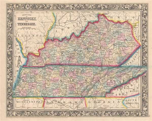
County Map of Kentucky, and Tennessee.
1860 (dated) 11 x 14 in (27.94 x 35.56 cm) 1 : 3041280
1860 (dated) 11 x 14 in (27.94 x 35.56 cm) 1 : 3041280
Description
This is an 1861 Samuel Augustus Mitchell, Jr. map of Kentucky and Tennessee, two states that would soon fight each other on opposite sides of the onrushing American Civil War. The map depicts the region from Missouri to Virginia, North Carolina, and South Carolina and from Illinois, Indiana, and Ohio to Mississippi, Alabama, Georgia, and South Carolina.
Kentucky and Tennessee during the Civil War
Kentucky originally declared neutrality because its citizenry preferred the role of mediator between the two sides to 'the wicked purpose of subduing [her] sister Southern states.' Tennessee chose a different path, becoming the last state to declare secession from the Union and join the Confederacy. As it happened, Tennessee saw brutal fighting, and only Virginia experienced more battles. Tennessee also has the dubious distinction of being the only state where a major battle or skirmish was fought in every single county.
Both sides respected Kentucky's neutrality, until Confederate Major General Leonidas Polk ordered Brigadier General Gideon Johnston Pillow to occupy Columbus, a strategic point on the Mississippi River and the terminus of the Mobile and Ohio Railroad (which is illustrated but not labeled here). This move forced Union Brigadier General Ulysses S. Grant, to leave Cairo, Illinois and invade Kentucky at Paducah. In the end, Kentucky's legislature passed a resolution ordering the withdrawal of only the Confederate forces, in opposition to the governor's declaration stating that both sides should vacate the state (Governor Magoffin was a Southern sympathizer). Thus, Kentucky and Tennessee, two states with populations divided over which side to take, ended up on opposite sides of the Civil War.
Highly detailed, individual counties are illustrated, labeled, and shaded different colors to allow for easy differentiation. Cities, towns, and villages throughout the two states are labeled, including Memphis, Nashville, Lexington, Frankfort, and Louisville. Rivers are illustrated as well, though only a small portion of them are labeled, along with the Cumberland Mountains. The whole is surrounded by the attractive floral border common to Mitchell atlases between 1860 and 1865. This map encapsulates the 'brother against brother' mythology and reality that surrounds the membor of the Civil War, as the populations of both Kentucky and Tennessee were extremely divided over whther to support the Union or the Confederacy.
This map was prepared by S. A. Mitchell Jr. for inclusion in the 1861 edition of Mitchell's New General Atlas. Like many American map publishers of this period, Mitchell did not regularly update his copyrights, consequently this map is dated and copyrighted to 1860: 'Entered according to Act of Congress in the Year 1860 by S. Augustus Mitchell Jr. in the Clerk's Office of the District Court of the U.S. for the Eastern District of Pennsylvania.'
Cartographer
Samuel Augustus Mitchell (March 20, 1792 - December 20, 1868) began his map publishing career in the early 1830s. Mitchell was born in Bristol, Connecticut. He relocated to Philadelphia in 1821. Having worked as a school teacher and a geographical writer, Mitchell was frustrated with the low quality and inaccuracy of school texts of the period. His first maps were an attempt to rectify this problem. In the next 20 years Mitchell would become the most prominent American map publisher of the mid-19th century. Mitchell worked with prominent engravers J. H. Young, H. S. Tanner, and H. N. Burroughs before attaining the full copyright on his maps in 1847. In 1849 Mitchell either partnered with or sold his plates to Thomas, Cowperthwait and Company who continued to publish the Mitchell's Universal Atlas. By about 1856 most of the Mitchell plates and copyrights were acquired by Charles Desilver who continued to publish the maps, many with modified borders and color schemes, until Mitchell's son, Samuel Augustus Mitchell Junior, entered the picture. In 1859, S.A. Mitchell Jr. purchased most of the plates back from Desilver and introduced his own floral motif border. From 1860 on, he published his own editions of the New General Atlas. The younger Mitchell became as prominent as his father, publishing maps and atlases until 1887, when most of the copyrights were again sold and the Mitchell firm closed its doors for the final time. More by this mapmaker...
Source
Mitchell, S. A., Mitchell's New General Atlas Containing Maps of the Various Countries of the World, Plans of Cities, Etc., embraced in Forty-Seven Quarto Maps, Forming a series of Seventy-Six Maps and Plans, together with Valuable Statistical Tables (Philadelphia: S. Augustus Mitchell, Jr.) 1861.
Mitchell's New General Atlas was published by Samuel Augustus Mitchell, Jr., the son of the prolific cartographer Samuel Augustus Mitchell. Many of the plates are derived from the his father's Mitchell's Universal Atlas, but not directly. The Mitchell's Universal Atlas was initially sold to Thomas, Cowperthwait, and Company in 1849, and again to Charles Deliver in 1856. It was Deliver who introduced the new vibrant color scheme, abandoning the older Mitchell's Universal Atlas green borders and themes for bright reds, blues, and yellows. Samuel Augustus Mitchell, Jr. acquired the Deliver plates in 1859. He added his own floral motif border, but doubled down on the vibrant color scheme, thus introducing to the American public the most vividly colored American atlas of the 19th century. In 1860, he published the first edition of his New General Atlas and, despite a slump in sales during the American Civil War, attained a level of success to rival his father. Mitchell would continue to publish the New General Atlas until 1887, when the firm formally closed.
Condition
Very good. Even overall toning. Light soiling. Blank on verso.
References
Rumsey 0565.016 (1860 edition). Phillips (Atlases) 831-16. New York Public Library, Map Division, 1510808.