This item has been sold, but you can get on the Waitlist to be notified if another example becomes available, or purchase a digital scan.
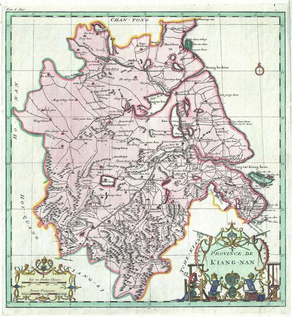
1737 D'Anville Map of Kiang-Nan, China (Jiangsu Province, Shanghai Municipality)
KiangNan-anville-1737$275.00

Title
Province de Kiang-Nan.
1737 (undated) 14.25 x 13.25 in (36.195 x 33.655 cm) 1 : 2000000
1737 (undated) 14.25 x 13.25 in (36.195 x 33.655 cm) 1 : 2000000
Description
A rare and important 1737 map of Kiang-Nan Province, China, by the prominent French cartographer Jean Baptiste Bourguignon d'Anville. Centered loosely on Nanjing, the map roughly covers the modern-day Jiangsu Province and Shanghai Municipality. Shanghai is identified as 'Chang-Hai-Hien.' Throughout the map is quite detailed, being perhaps the first western map to focus on this area with any scientific precision. The map is derived from 1708 – 1721 surveys completed jointly by the Chinese government and Jesuit missionaries at the order of the Kangxi Emperor. The present example is beautifully produced with bright color and elaborate gold foiling on the cartouche-work. Although it is hard to know with certainly, based upon the color work, this is most likely from the Den Haag (The Hague) edition of D'Anville's atlas published by Henri Scheurleer, 1737.
Cartographer
Jean Baptiste Bourguignon d'Anville (1697 - 1782) was perhaps the most important and prolific cartographer of the 18th century. D'Anville's passion for cartography manifested during his school years when he amused himself by composing maps for Latin texts. There is a preserved manuscript dating to 1712, Graecia Vetus, which may be his earliest surviving map - he was only 15 when he drew it. He would retain an interest in the cartography of antiquity throughout his long career and published numerous atlases to focusing on the ancient world. At twenty-two D'Anville, sponsored by the Duke of Orleans, was appointed Geographer to the King of France. As both a cartographer and a geographer, he instituted a reform in the general practice of cartography. Unlike most period cartographers, D'Anville did not rely exclusively on earlier maps to inform his work, rather he based his maps on intense study and research. His maps were thus the most accurate and comprehensive of his period - truly the first modern maps. Thomas Basset and Philip Porter write: "It was because of D'Anville's resolve to depict only those features which could be proven to be true that his maps are often said to represent a scientific reformation in cartography." (The Journal of African History, Vol. 32, No. 3 (1991), pp. 367-413). In 1754, when D'Anville turned 57 and had reached the height of his career, he was elected to the Academie des Inscriptions. Later, at 76, following the death of Philippe Buache, D'Anville was appointed to both of the coveted positions Buache held: Premier Geographe du Roi, and Adjoint-Geographer of the Academie des Sciences. During his long career D'Anville published some 211 maps as well as 78 treatises on geography. D'Anville's vast reference library, consisting of over 9000 volumes, was acquired by the French government in 1779 and became the basis of the Depot Geographique - though D'Anville retained physical possession his death in 1782. Remarkably almost all of D'Anville's maps were produced by his own hand. His published maps, most of which were engraved by Guillaume de la Haye, are known to be near exact reproductions of D'Anville' manuscripts. The borders as well as the decorative cartouche work present on many of his maps were produced by his brother Hubert-Francois Bourguignon Gravelot. The work of D'Anville thus marked a transitional point in the history of cartography and opened the way to the maps of English cartographers Cary, Thomson and Pinkerton in the early 19th century. More by this mapmaker...
Source
D'Anville, i>Atlas Général de la Chine, de la Tartarie Chinoise, et du Thibet, (Paris: Dezauche) 1737.
D'Anville's Atlas Général de la Chine is considered the first authoritative western Atlas of China. The atlas of first appeared in conjunction with Jean-Baptiste du Halde’s 1735 4-volume Description Géographique, Historique, Chronologique, Politique et Physique de l’Empire de la Chine et de la Tartarie Chinoise, for which D'Anville excuted some 41 maps. Two years later, in 1737, D'Anville reissued the maps in a separately published atlas with some additional maps an images to a total of 50. The atlas was published both in Paris (Dezauche) and The Hague (Scheurleer) as Atlas Général de la Chine, de la Tartarie chinoise, et du Thibet and Nouvel atlas de la Chine, de la Tartarie chinoise et du Thibet, respectively. The maps themselves are derived from joint Chinese-Jesuit surveys compiled in atlas form (Huang yu quan lan fen sheng tu /皇與全覽分省圖 / Zhongguo ge sheng di tu / 'The Kangxi Provincial Atlas of China') between 1708 and 1721 for the administrative use of the Kangxi Emperor. D'Anville's atlas is notable for many firsts, including the first appearance of Tibet in a western atlas.
Condition
Very good. Slight edge wear affecting outer margins.
References
OCLC 15998804. Mario Cams ‘The China Maps of Jean-Baptiste Bourguignon d’Anville’ Imago Mundi (2013, vol. 66 pt. 1: 51-69).