This item has been sold, but you can get on the Waitlist to be notified if another example becomes available.
1972 Amir Publishing Map of Kibbutzim in Israel
KibbutzimIsrael-amir-1972$200.00


Title
Map of the Kibbutzim in Israel / הקיבוצים בישראל.
1972 (dated) 47 x 17 in (119.38 x 43.18 cm) 1 : 360000
1972 (dated) 47 x 17 in (119.38 x 43.18 cm) 1 : 360000
Description
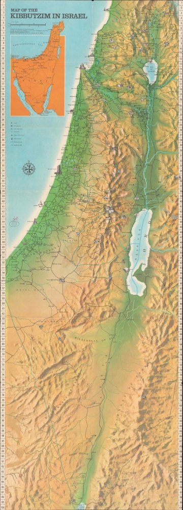
A large and highly detailed 1972 / 1975 map of Israel noting kibbutzim, published by Amir Publishing for the Federation of the Kibbutz Movements. Among other features, the map and information on the verso are keen to point out the variety of endeavors undertaken by kibbutzim.
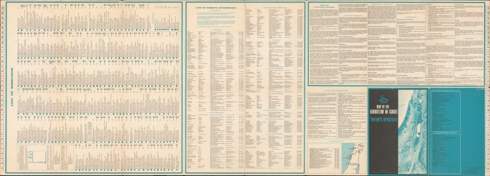
Aside from grid coordinates, the 250 kibbutzim and Nahal settlements listed on the verso also come with an address and symbols indicating their affiliation and function (including ulpanim - Hebrew language schools for new immigrants - and historical sites). The verso also lists kibbutzim with an industrial function which were members of the Union of Kibbutz Industries, an arm of the Federation of the Kibbutz Movements. Blocks of text at right discuss the history of the Federation of the Kibbutz Movements and its constituent parts, along with information on regional kibbutz movements, and kibbutz guest houses.
A Closer Look
The entirety of Israel, including territories occupied following the 1967 Six-Day War, is displayed. Cities and archaeological sites, including some in neighboring countries, are indicated by pictorial illustrations, while kibbutzim are noted with stars inside of circles and Nahal settlements with a Star of David inside a circle. Roads, waterways, and mountains are marked in considerable detail. An inset map of the Sinai Peninsula, which was occupied by Israel at this time, appears at top-left. An intricate grid surrounds the map, allowing for the precise location of kibbutzim, which are listed on the verso with their coordinates.Aside from grid coordinates, the 250 kibbutzim and Nahal settlements listed on the verso also come with an address and symbols indicating their affiliation and function (including ulpanim - Hebrew language schools for new immigrants - and historical sites). The verso also lists kibbutzim with an industrial function which were members of the Union of Kibbutz Industries, an arm of the Federation of the Kibbutz Movements. Blocks of text at right discuss the history of the Federation of the Kibbutz Movements and its constituent parts, along with information on regional kibbutz movements, and kibbutz guest houses.
What is a Kibbutz?
A kibbutz is an Israeli collective community. Established in 1910 at the southern tip of the Sea of Galilee, Degania Alef was the first kibbutz. Founded initially as utopian communities combining socialism and Zionism, some modern kibbutzim have been privatized, and their communal lifestyle modernized. Although traditionally large farms, as can be seen from the list on the verso here, many kibbutzim had moved into manufacturing by the 1970s. Kibbutz communities today rely less on agriculture and more on high-tech enterprises and industry. There were 270 kibbutzim in Israel in 2010, and their farms and factories accounted for 9% of Israel's total industrial output.Publication History and Census
This map was edited by Immanuel Blaushild and Eytan Hess of the Amir Publishing for the Federation of the Kibbutz Movements. Though dated 1972 on the recto, publication information on the verso indicates that this is a 1975 printing. Due to uncertainty over the publication date, the map is listed multiple times in the OCLC with either or both dates. Regardless of date, the map is held by eleven institutions in North America as well as the University of Cambridge, the Royal Danish Library, the National Library of Israel, Haifa University, and Yad Ben Zvi. An updated edition was published in 1983 and another in 1994, though by a different publisher and after the Federation had merged into the United Kibbutz Movement.CartographerS
Amir Publishing Company were a Tel Aviv publishing house, active from about 1970 to 1990, specializing in pictorial maps of Israeli cities. Their output included maps of Tel Aviv, Jerusalem, Netanyah, Jaffa, Hammat, Elatand and Atikah. They also printed complete maps of Israel. More by this mapmaker...
Immanuel Blaushild (fl. 1970-1990) is an Israeli illustrator, editor and mapmaker. He worked in Tel Aviv, as art director for the Amir Publishing Company, a Tel Aviv firm specializing in pictorial maps of Israeli cities. Learn More...
Federation of the Kibbutz Movements (c. 1963 - 1983) was an umbrella organization for kibbutzim throughout Israel best known for publishing a map in multiple editions with up-to-date information on the location and activities of kibbutzim. A branch of the federation, the Union of Kibbutz Industries, provided information on the industries and output of kibbutz enterprises. The Federation appears to have merged with other Kibbutz organizations, combining with United Kibbutz Movement, now known simply as the Kibbutz Movement. Learn More...
Condition
Good. Some edge wear. A couple of minor margin splits, repaired with archival tissue on verso. Wear on original fold lines.
References
OCLC 5408247, 790709401, 50126837, 908425655.