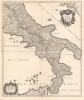
1706 Jaillot Map of the Kingdom of Naples, Italy
KingdomOfNaples-jaillot-1706$900.00


Title
Le royaume de Naples divisé en toutes ses provinces...
1706 (dated) 34.5 x 24.25 in (87.63 x 61.595 cm) 1 : 700000
1706 (dated) 34.5 x 24.25 in (87.63 x 61.595 cm) 1 : 700000
Description
This is Hubert Jaillot's magnificent 1703/06 map of southern Italy, then dominated by the Kingdom of Naples.
A Closer Look
Coverage embraces the southern half of the italian peninsula, including parts of northern Sicily. It is loosly dervied from the work of Nicolas Sanson, but is here engraved on a larger scale with superior detail. Jaillot's map improves on its predecessors by correcting the Gulf of Taranto - here lacking the spurious island of 'M. Sardo', which appears on virtually every prior map.A Sumptuous Engraving
The geographical detail and lettering are sharply and clearly executed. Mountains, forests, and marshlands are shown pictorially; the respective sizes of towns and cities are clearly indicated with symbols. Other features, notably salt pans (salines), are also clearly pictured. But it is on the cartouches that Jaillot flourishes, utilizing his artistic background as a sculptor. The title and dedicatory cartouche are framed with a sumptuous border. It is surmounted by the dedicatee's arms (Philip V of Spain and IV of Naples), flanked by two trumpet-blowing avatars of fame, shown in conjunction with spears, shields, and arrows emphasizing military prowess. The bottom of the cartouche is embellished with two fiercely rearing horses, held in rein by footmen. At the bottom left, the cartouche of scales is enclosed in a frame of vines.Publication History and Census
The northern sheet of this map was engraved by Jaillot in 1703 (unjoined examples bear this date in the lower margin of the upper sheet). The lower portion, bearing the date in the scale cartouche, was completed in 1706. Both maps were added to Jaillot's Atlas François, which, despite its 1695 dating, typically contains numerous later additions. The map would be re-printed by Covens and Mortier several times in the mid-18th century and again by Dezauche in 1785. The Jaillot edition of the map is cataloged - both in its separate sheets and joined - in only eight institutional collections.Cartographer
Alexis-Hubert Jaillot (c. 1632 - 1712) followed Nicholas Sanson (1600 - 1667) and his descendants in ushering in the great age of French Cartography in the late 17th and 18th century. The publishing center of the cartographic world gradually transitioned from Amsterdam to Paris following the disastrous inferno that destroyed the preeminent Blaeu firm in 1672. Hubert Jaillot was born in Franche-Comte and trained as a sculptor. When he married the daughter of the Enlumineur de la Reine, Nicholas I Berey (1610 - 1665), he found himself positioned to inherit a lucrative map and print publishing firm. When Nicholas Sanson, the premier French cartographer of the day, died, Jaillot negotiated with his heirs, particularly Guillaume Sanson (1633 - 1703), to republish much of Sanson's work. Though not a cartographer himself, Jaillot's access to the Sanson plates enabled him to publish numerous maps and atlases with only slight modifications and updates to the plates. As a sculptor and an artist, Jaillot's maps were particularly admired for their elaborate and meaningful allegorical cartouches and other decorative elements. Jaillot used his allegorical cartouche work to extol the virtues of the Sun King Louis IV, and his military and political triumphs. These earned him the patronage of the French crown who used his maps in the tutoring of the young Dauphin. In 1686, he was awarded the title of Geographe du Roi, bearing with it significant prestige and the yearly stipend of 600 Livres. Jaillot was one of the last French map makers to acquire this title. Louis XV, after taking the throne, replaced the position with the more prestigious and singular title of Premier Geographe du Roi. Jaillot died in Paris in 1712. His most important work was his 1693 Le Neptune Francois. Jalliot was succeeded by his son, Bernard-Jean-Hyacinthe Jaillot (1673 - 1739), grandson, Bernard-Antoine Jaillot (???? – 1749), and the latter's brother-in-law, Jean Baptiste-Michel Renou de Chauvigné-Jaillot (1710 - 1780). More by this mapmaker...
Condition
Very good. Two marginal mends. Wear at juncture of folds with virtually no loss. Printed to two large folio sheets, joined at publication for binding. Original outline color.
References
OCLC 494728347. Rumsey 12044.123 and 12044.124.