This item has been sold, but you can get on the Waitlist to be notified if another example becomes available, or purchase a digital scan.
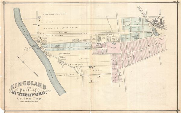
1876 Walker Map of Kingsland and Part of Rutherford, New Jersey
KingslandRutherford-walker-1876$87.50

Title
Kingsland and part of Rutherford, Union Township.
1876 (undated) 16.75 x 27.25 in (42.545 x 69.215 cm)
1876 (undated) 16.75 x 27.25 in (42.545 x 69.215 cm)
Description
Detailed 1876 map of Kingsland and part of Rutherford in Union Township, New Jersey. Shows roads, property boundaries and owners' names. Published as plates 148-149 in Walker & Pease' exquisite 'topographical, illustrated, historical, descriptive' Atlas of Bergen County, New Jersey, 1876. On verso appear lovely lithographic views of area residences, businesses, and a coal ash factory.
Source
Walker, A. H., and Pease, C. C. Atlas of Bergen County, New Jersey, 1876.
Condition
Good. Even overall toning. Original centerfold exhibits some wear and in verso reinforcement. Minor discolorations here and there. Edge wear mostly confined to margins.
References
Phillips (Atlases) #2152.