
This item below is out of stock, but another example (left) is available. To view the available item, click "Details."
Details
1948 Jones Pictorial Map of Kodiak Island, Alaska
1948 (undated) $450.00
1948 Jones Pictorial Map of Kodiak Island, Alaska
Kodiak-jones-1948$125.00

Title
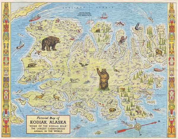
Pictorial Map of Kodiak, Alaska 'Home of the Kodiak Bear' the Largest Carnivorous Animal in the World.
1948 (undated) 17 x 22 in (43.18 x 55.88 cm) 1 : 380160
1948 (undated) 17 x 22 in (43.18 x 55.88 cm) 1 : 380160
Description
This is a 1948 Lowell E. Jones pictorial map of Kodiak, Alaska. Oriented from the east, the map depicts the whole of Kodiak Island from Shelikof Strait to Sitkaudak Island and from Olga Bay to Afgonak Island. Standing near the center of the map, a Kodiak bear stands on its hind legs and waves at the viewer, while a second Kodiak is illustrated on the upper left. Several caribou, eagles, and other wildlife are also included. Numerous bays, straits, and smaller islands are labeled throughout. Inhabited locations are few and far between, the town of Kodiak merits a star, while all other settlements appear to either be canneries or native villages. The site of the first white settlement in Alaska, which per the map was established in 1784, is also marked near Three Saints Bay. Half a dozen boats make their way through the waters surrounding Kodiak Island, some of which are steam vessels while others are sailing ships. Other content in present on verso, including a pictorial map of Alaska, information about Kodiak and a drawn bird's eye view of the city, along with a charming illustration of a Kodiak bear.
This map was produced and copyrighted by Lowell E. Jones in 1948. The map is undated, but we are following David Rumsey's date of 1948.
This map was produced and copyrighted by Lowell E. Jones in 1948. The map is undated, but we are following David Rumsey's date of 1948.
Cartographer
Lowell E. Jones (fl. c. 1935 - 1957) was a Los Angeles graphic artist. He drew pictorial maps and sold them at tourist locations around Los Angeles for twenty-five cents each. More by this mapmaker...
Condition
Very good. Verso repairs to fold separations. Pictorial map of Alaska and information about Kodiak, Alaska on verso.
References
Rumsey 8878.004.