This item has been sold, but you can get on the Waitlist to be notified if another example becomes available, or purchase a digital scan.
1951 Army Map Service Road Map of Korea
Korea-ams-1951$130.00

Title
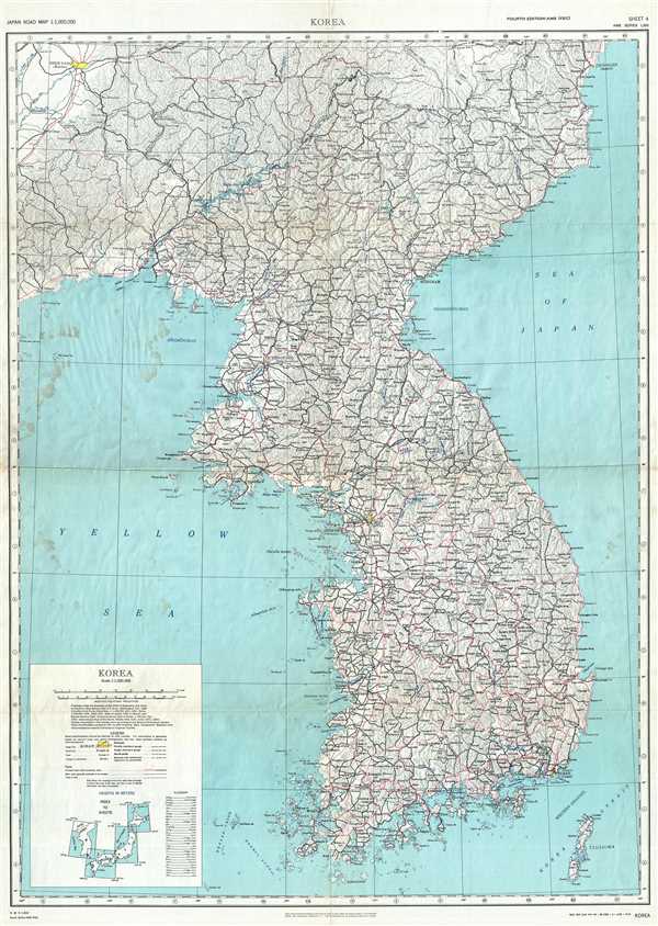
Korea. AMS Series L302 Sheet 4.
1951 (dated) 38 x 27 in (96.52 x 68.58 cm) 1 : 1000000
1951 (dated) 38 x 27 in (96.52 x 68.58 cm) 1 : 1000000
Description
This is a 1951 Korean War (1950 – 1953) U.S. Army Map Service road map of Korea. This map depicts the entire Korean peninsula, including both North (DPRK) and South Korea (ROK), from Pusan to the Chinese border, and northern Manchuria, including Mukden and Seishin. The road network appears to be fully depicted, with different grades of road depicted in different colors. Railroads are present as well. The map highlights large urban areas in yellow, such as Seoul (Soul), Pyongyang (P'yongyang), and Mukden (Shen-Yang). Small cities and towns spread out across the peninsula. The coast is depicted with a high degree of detail.
This map is Sheet 4 in Army Map Service Series L302 and was prepared under the direction of the Chief of Engineers, U.S. Army, by the Army Map Service in 1945. This map was based on Japanese maps captured following the end of the Second World War by U.S. Army Intelligence. This example dates from 1951 and shows revised road classifications done by the Army engineers.
This map is Sheet 4 in Army Map Service Series L302 and was prepared under the direction of the Chief of Engineers, U.S. Army, by the Army Map Service in 1945. This map was based on Japanese maps captured following the end of the Second World War by U.S. Army Intelligence. This example dates from 1951 and shows revised road classifications done by the Army engineers.
Condition
Very good. A few verso repairs along fold lines. Blank on verso.
References
OCLC 688477219.