This item has been sold, but you can get on the Waitlist to be notified if another example becomes available, or purchase a digital scan.
1706 Jaillot Map of Brittany, France
LaBretagne-jaillot-1706$225.00

Title
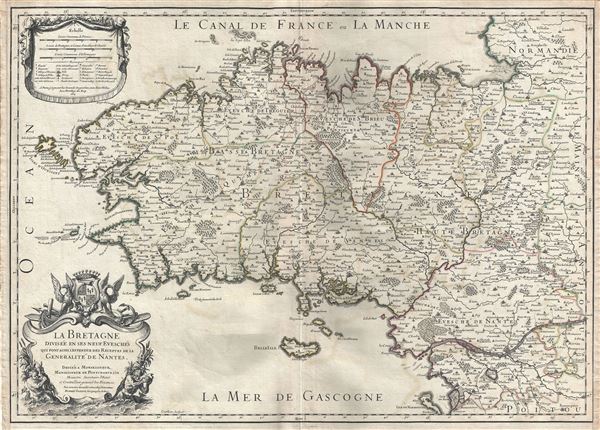
La Bretagne Divisee en ses neuf Evesches qui font aussi l'estendue des Receptes de la Generalite de Nantes.
1706 (undated) 18.5 x 25.5 in (46.99 x 64.77 cm) 1 : 548000
1706 (undated) 18.5 x 25.5 in (46.99 x 64.77 cm) 1 : 548000
Description
This is a scarce 1706 map of Brittany, France by Alexis-Hubert Jaillot. It covers the former province of Brittany from Granville south to Noirmoutier-en-l'lle and from the Celtic Sea inland as far as Craon. The region includes the departments of Finistere, Cotes-d'Amor, Ille-et-Vilaine, Loire-Atlantique (previously known as Loire-Inferieure) and Morbihan. The map renders the entire region in extraordinary detail offering both topographical and political information with forest and mountains beautifully rendered in profile.
The map identifies the island of Ouessant, the north-westernmost part of France. This western region of Brittany (department of Finistere) is known for its cider production and excellent boar hunting. The Ille-et-Vilaine region, in the northeast of Brittany, is famous for its seafood, and especially oysters. The dramatic island and castle of Mont Saint-Michel is depicted just off the coast. The region of Loire-Atlantique, located in the southeast, is part of the Loire Valley wine region, and is especially known for its production of Muscadet, a white wine produced from the Melon de Bourgogne grape variety. This area is also famous for a variety of cow's milk cheese known as Fromage du Cure Nantais. Morbihan is an exceptionally beautiful part of the Breton cost noted for its many islands, many of which are now privately owned by movie stars, politicians, well known musicians and other influential people. Morbihan is named for its most unusual feature, a large inland sea near Vannes, itself called The Morbihan. This region is also the home of the mysterious megalithic ruins at Carnac.
A beautifully engraved title cartouche adorns the lower left quadrant. This map was created by Alexis-Hubert Jaillot in 1706 and engraved by Robert Cordier.
Cartographer
Alexis-Hubert Jaillot (c. 1632 - 1712) followed Nicholas Sanson (1600 - 1667) and his descendants in ushering in the great age of French Cartography in the late 17th and 18th century. The publishing center of the cartographic world gradually transitioned from Amsterdam to Paris following the disastrous inferno that destroyed the preeminent Blaeu firm in 1672. Hubert Jaillot was born in Franche-Comte and trained as a sculptor. When he married the daughter of the Enlumineur de la Reine, Nicholas I Berey (1610 - 1665), he found himself positioned to inherit a lucrative map and print publishing firm. When Nicholas Sanson, the premier French cartographer of the day, died, Jaillot negotiated with his heirs, particularly Guillaume Sanson (1633 - 1703), to republish much of Sanson's work. Though not a cartographer himself, Jaillot's access to the Sanson plates enabled him to publish numerous maps and atlases with only slight modifications and updates to the plates. As a sculptor and an artist, Jaillot's maps were particularly admired for their elaborate and meaningful allegorical cartouches and other decorative elements. Jaillot used his allegorical cartouche work to extol the virtues of the Sun King Louis IV, and his military and political triumphs. These earned him the patronage of the French crown who used his maps in the tutoring of the young Dauphin. In 1686, he was awarded the title of Geographe du Roi, bearing with it significant prestige and the yearly stipend of 600 Livres. Jaillot was one of the last French map makers to acquire this title. Louis XV, after taking the throne, replaced the position with the more prestigious and singular title of Premier Geographe du Roi. Jaillot died in Paris in 1712. His most important work was his 1693 Le Neptune Francois. Jalliot was succeeded by his son, Bernard-Jean-Hyacinthe Jaillot (1673 - 1739), grandson, Bernard-Antoine Jaillot (???? – 1749), and the latter's brother-in-law, Jean Baptiste-Michel Renou de Chauvigné-Jaillot (1710 - 1780). More by this mapmaker...
Condition
Very good. Minor wear along original centerfold. Original platemark visible. Minor offsetting and foxing.