1891 Sonnet Map of France
LaFranceColonie-sonnet-1891$200.00
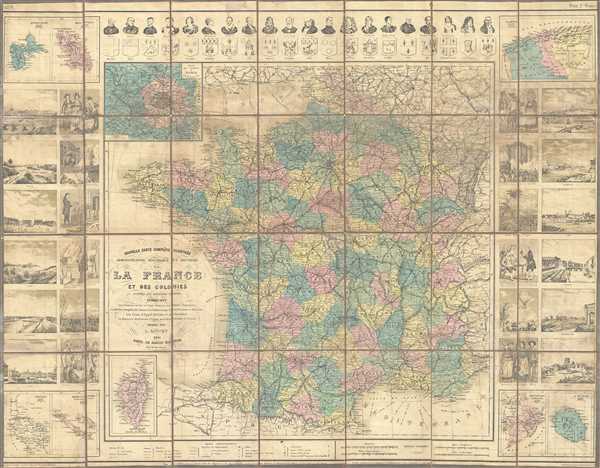

Title
Nouvelle Carte Complete Illustree Administrative Historique et Routiere de la France et des Colonies.
1891 (dated) 25.5 x 33 in (64.77 x 83.82 cm) 1 : 1753000
1891 (dated) 25.5 x 33 in (64.77 x 83.82 cm) 1 : 1753000
Description
This is a beautiful 1891 map of France by Sonnet. It covers the entire nation in extraordinary detail noting cities, departments, rivers, canals, roads, railways, and a host of other topographical features throughout. Insets of Corsica and Paris are included in the bottom and top left quadrants of the map.
The whole is surrounded by 24 illustrations of major cities and historic events in the left and right margins. Four additional insets in the four quadrants detail Algeria, Guadeloupe, Martinique, Senegal, New Caledonia, Cochin China, and Reunion. Along the top of the map are portraits of 20 French personalities with coat of arms of 20 major cities. The map was prepared by L. Sonnet and issued in 1891 by Le Bailly.
The whole is surrounded by 24 illustrations of major cities and historic events in the left and right margins. Four additional insets in the four quadrants detail Algeria, Guadeloupe, Martinique, Senegal, New Caledonia, Cochin China, and Reunion. Along the top of the map are portraits of 20 French personalities with coat of arms of 20 major cities. The map was prepared by L. Sonnet and issued in 1891 by Le Bailly.
Condition
Very good. Dissected and backed with linen. Overall age toning. Some foxing. Wear along original folds, with some tears to linen folds, reinforced.
References
OCLC: 642698268.