
1899 Stoddard Tourist Map of Lake Champlain


This item has been sold.
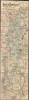
Map of Lake Champlain.
One of the Earliest Tourist Maps of Lake Champlain.
- Digital Map Information
- Suitable for large format printing
- File Size: 21.34 MB
- File Type: ZIP / TIFF
- ICC color profile embedded
- Delivered instantly via download link
One of the Earliest Tourist Maps of Lake Champlain.
A scarce 1899 Seneca Ray Stoddard map of Lake Champlain. It was published at the height of the lake's late 19th-century popularity as a tourist destination.A Closer Look
Presented in an unusual, elongated format, this map covers the entirety of Lake Champlain and the adjacent parts of Vermont, New York, and Quebec, from Missisquoi Bay and Rouses Point to Fort Ticonderoga. Stoddard details rail lines (various other lines in addition to the Central Vermont), basic topography, and roadways. On the lake, islands, reefs, points, bays, and other features are labeled, including historical notes such as the site of the 1814 Battle of Plattsburgh. There are insets detailing the lower portions of the lake from Whitehall to Fort Ticonderoga, a large inset of Lake George, steamboat routes from Plattsburgh, milage from Burlington, milage from Westport, Milage from Port Kent, the Richelieu River, the route of the steamer Coquette, and railroad connections from Washington D.C., Philadelphia, Baltimore, New York, and Boston.Tourism to Lake Champlain
By 1899, Lake Champlain was already a popular tourism destination, especially during the summer months. The lake's natural beauty, combined with its historic significance as a site of battles during the Revolutionary War and the War of 1812, attracted visitors from across the northeastern United States. As rail networks extended into rural areas of Vermont and New York, they connected cities Burlington and Plattsburgh to New York City, Boston, and Montreal. This easier access allowed a larger number of middle- and upper-class tourists to visit Lake Champlain. Steamboats were common on the lake itself, ferrying tourists around the lake to enjoy scenic views of the Adirondack Mountains and the Green Mountains. Many visitors stayed at lakeside resorts or in the growing number of summer cottages. Fishing, boating, and swimming were among the favored activities, while the lake's calm waters and cool breezes offered relief from urban heat. This period marked the early stages of Lake Champlain's development into a well-known recreational area.Publication History and Census
Stoddard first issued this map in 1892, and as such, it was one of the earliest tourist maps to focus exclusively on Lake Champlain. He sold it independently by mail order. Stoddard issued numerous revised editions to at least 1911. The present example is the 7th revised edition, issued in 1899. Despite many editions, this map is quite rare, with very few examples identified in institutional collections. Earlier and later editions of the map are independently cataloged in the OCLC (61296932) at eight institutions, but not this edition.Cartographer
Seneca Ray Stoddard (May 13, 1844 – April 26, 1917) was an American landscape photographer known for his images of New York's Adirondack Mountains. He was also a naturalist, writer, poet, artist, and cartographer. His writings and photographs helped to popularize the Adirondacks as a vacation destination in the late 19th century. Stoddard was born at Wilton, in Saratoga County, New York, May 13, 1844. Largely self-taught, he left home at 16 to paint advertising and decorative scenes on railroad cars. Around 20, Stoddard discovered a passion for photography. His work initially focused on his hometown of Glens Falls, but quickly expanded to cover much of the Adirondack region. In 1873, he published guides to Saratoga Springs and Lake George, which he updated and revised each of the subsequent five years. In 1878, the guide was expanded to Lake George and Lake Champlain. His best-known work is the 1873 guidebook, The Adirondacks: Illustrated, revised and reprinted through 1914. In 1874, he issued the first tourist map of the Adirondacks. This was followed by a 1878 topographical survey of the Adirondacks. In 1882, Stoddard invented 'a camera attachment for use in dry-plate photography and to perfect the magnesium flash for taking night photographs.' In early 1892, he was invited to give an illustrated lecture to the New York State Legislature that was influential in the creation of the Adirondack Park. In addition to his work in New York, Stoddard traveled extensively. His travels took him to Alaska in 1892, Florida and Cuba in 1894, and later he toured the American West and Southwest. In 1895, he traveled to Bermuda, the Holy Land, Italy, Switzerland, and France. In 1897, he went to England, the Orkney, Shetland, and Faroe Islands, Iceland, Norway, Denmark, Germany, and Russia. His trips became the basis for illustrated lecture tours, and two photographic travel books: The Cruise of the Friesland and The Midnight Sun. In 1906, he started Stoddard's Northern Monthly, a short-lived magazine that featured articles on the Adirondacks, fiction, and foreign travel. Stoddard died at his home in Glens Falls, New York, on April 26, 1917, and is interred in Pineview Cemetery. Today, his photography is housed at the Chapman Historical Museum in Glens Falls, and the Adirondack Museum in Blue Mountain Lake, New York. Further Details...
Condition
Good. Laid down on archival tissue. A few points of infill on old fold lines, specifically near Burlington and in Lake Champlain to the right of the title.
References
OCLC 61296932 (different editions). OCLC 51774269 (entire book, listing co-mingles multiple editions and formats).