This item has been sold, but you can get on the Waitlist to be notified if another example becomes available, or purchase a digital scan.
1730 Chopy Map of Lake Geneva (Lac Leman) and Environs, France and Switzerland
LakeGeneva-chopy-1730$375.00


Title
Carte du Lac de Genève et des pays circonvoisins...
1730 (undated) 23 x 32 in (58.42 x 81.28 cm) 1 : 142000
1730 (undated) 23 x 32 in (58.42 x 81.28 cm) 1 : 142000
Description
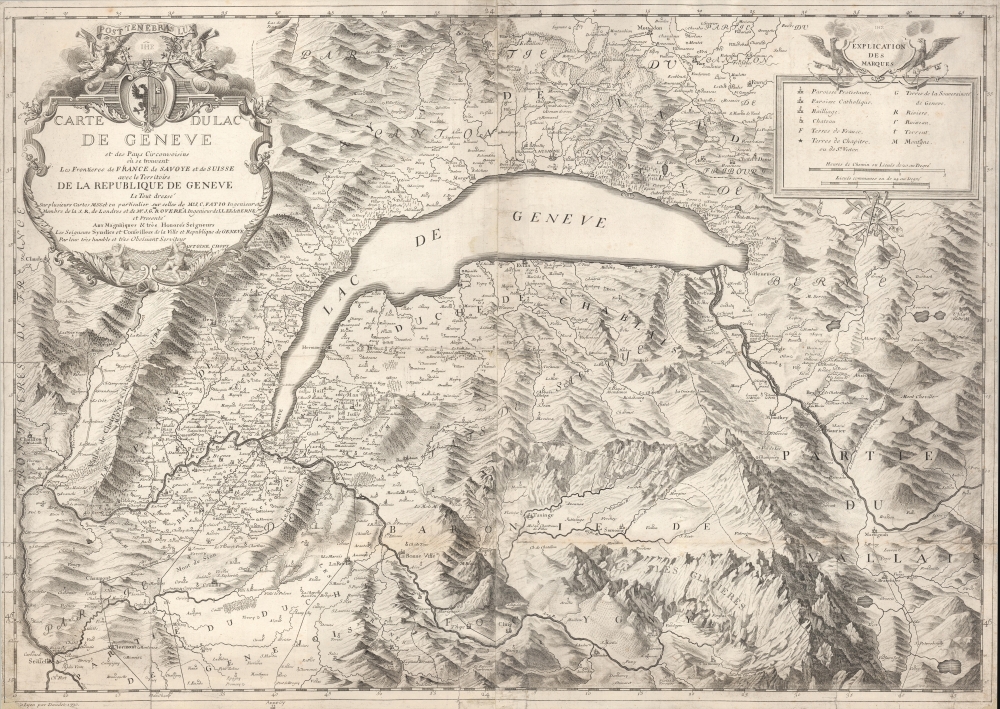
A large-format 1730 Antoine Chopy map of Lake Geneva and environs, covering the northwestern end of the European Alpine region that today straddles the border between France and Switzerland. It was published in Histoire de Genève, rectifiée et augmentée par d'amples notes, an authoritative and comprehensive history of the city.
The map's key includes various symbols and abbreviations as well as two scales in 'road hours' and communal leagues. Aside from towns and parishes, roads, mountains, rivers, lakes, and administrative borders are indicated. In addition to Geneva itself, other important towns in the region are recorded, including Lausanne. The spellings of some, at least in standard French, have changed in the years since Chopy made his map, such as Nyon instead of Nion and Seyssel instead of Seissel (notable for being the name of two towns on either side of the river, both in France but in two separate départements). In 2019, the three French communes of Bellegarde (sur-Valserine), Châtillon (en-Michaille), and Lancrans, all seen at left here, were merged to form the new commune of Valserhône.
The Rhône River system dominates the map. Rather atypically, the Rhône flows 'through' the lake, fed by the Rhône Glacier to the east and flowing out of the lake to the southwest, emptying into the Mediterranean near Arles. Lake Geneva is the largest lake in Switzerland and one of the largest in Western Europe. The Arve, a tributary of the Rhône, is fed by glaciers to the southeast (including on Mont Blanc) and flows to meet the Rhône near Geneva.
Due to the large number of researchers and engravers who worked on the updated edition of the Histoire de Genève, as well as a republication of the map in the 1960s and the cataloging of digitized copies, there are a proliferation of OCLC listings for both the map and the book. We note physical copies of the map cataloged in eight institutions, all in Europe, while the entire Histoire de Genève is more widely distributed.
A Closer Look
As mentioned in the title, the map covers the territory of the Republic of Geneva and nearby borderlands of France, Switzerland, and Savoy. The republic resulted from the Protestant Reformation, which saw the city become the seat of Calvinism. After a period of intense religious struggle in the early 16th century, Calvinism triumphed, though Catholics were able to regain a degree of autonomy and even influence within the republic, as seen by the number of Catholic parishes noted here. Geneva's staunch Calvinism prevented it from joining the Swiss Confederacy, despite very close cultural and diplomatic ties, until after the Napoleonic Wars.The map's key includes various symbols and abbreviations as well as two scales in 'road hours' and communal leagues. Aside from towns and parishes, roads, mountains, rivers, lakes, and administrative borders are indicated. In addition to Geneva itself, other important towns in the region are recorded, including Lausanne. The spellings of some, at least in standard French, have changed in the years since Chopy made his map, such as Nyon instead of Nion and Seyssel instead of Seissel (notable for being the name of two towns on either side of the river, both in France but in two separate départements). In 2019, the three French communes of Bellegarde (sur-Valserine), Châtillon (en-Michaille), and Lancrans, all seen at left here, were merged to form the new commune of Valserhône.
The Rhône River system dominates the map. Rather atypically, the Rhône flows 'through' the lake, fed by the Rhône Glacier to the east and flowing out of the lake to the southwest, emptying into the Mediterranean near Arles. Lake Geneva is the largest lake in Switzerland and one of the largest in Western Europe. The Arve, a tributary of the Rhône, is fed by glaciers to the southeast (including on Mont Blanc) and flows to meet the Rhône near Geneva.
Publication History and Census
This map was drawn by Antoine Chopy and engraved by Jean-Louis Daudet in Lyon in 1730. It appeared in the book Histoire de Genève, rectifiée et augmentée par d'amples notes, originally written by Jacob Spon in the 1680s and then updated by a team of scholars to be republished in 1730. Chopy credits Jean Christophe Fatio (a Genevan philosopher and intellectual) and Isaac Gamaliel Roverea (a Swiss cartographer and engineer) as influences on his map.Due to the large number of researchers and engravers who worked on the updated edition of the Histoire de Genève, as well as a republication of the map in the 1960s and the cataloging of digitized copies, there are a proliferation of OCLC listings for both the map and the book. We note physical copies of the map cataloged in eight institutions, all in Europe, while the entire Histoire de Genève is more widely distributed.
Cartographer
Antoine Chopy (1674 - August 31, 1760) was born in Narbonne and later moved to Geneva, where he worked at the college (now university) there. He began training as an engraver, eventually becoming known for engraving maps and panoramic views of Geneva. More by this mapmaker...
Condition
Good. Wear and discoloration along fold lines. A few marginal closed tears repaired and reinforced with archival tissue.