
This item below is out of stock, but another example (left) is available. To view the available item, click "Details."
Details
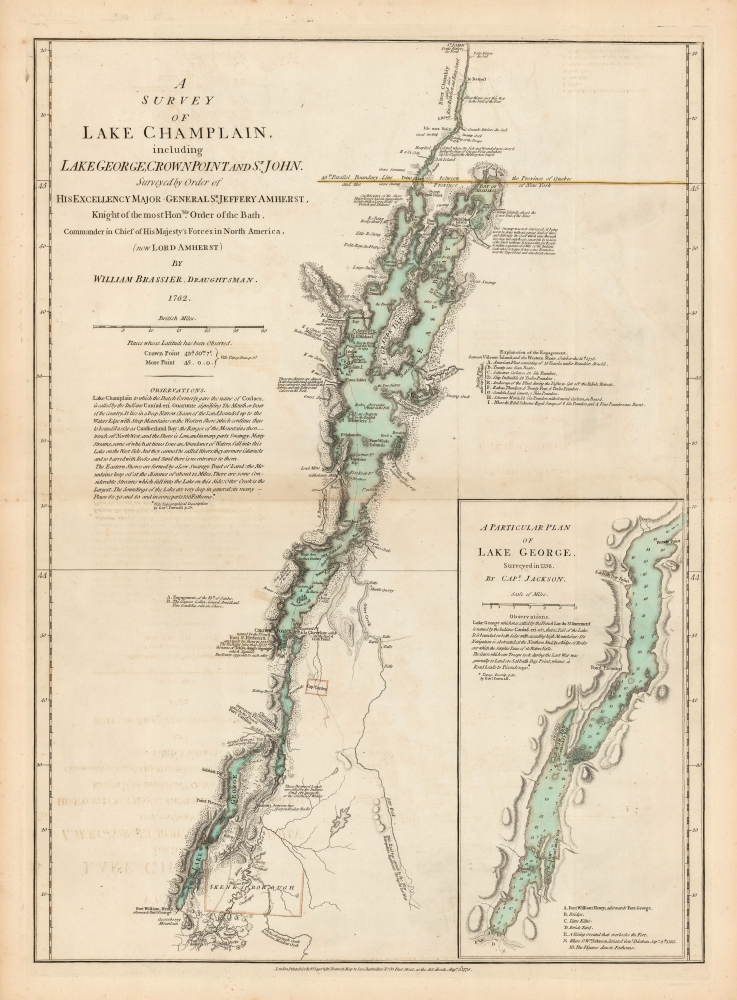
1776 Brassier Map of Lake Champlain and Lake George with the Battle of Valcour Island
1776 (dated) $8,500.00
1776 Brassier Map of Lake Champlain and Lake George with the Battle of Valcour Island
LakesChamplainGeorge-brasier-1776$3,250.00

Title
A Survey Of Lake Champlain, including Lake George, Crown Point And St. John. /A Particular Plan of Lake George.
1776 (dated) 26 x 18.75 in (66.04 x 47.625 cm) 1 : 400000
1776 (dated) 26 x 18.75 in (66.04 x 47.625 cm) 1 : 400000
Description
This is William Furness Brasier's 1762 map of Lakes Champlain and George, in its 1776 second state. The map overall is the first separate map of Lake Champlain and Lake George. Both this and its earlier state would certainly have been in the hands of the British officers leading the Fall 1777 campaign during the American Revolutionary War (1775 - 1783) culminating in a pivotal American victory at Saratoga.
First Detailed Map of Lake Champlain
The map is drawn from the surveys of William Brasier assisted by Dietrich Brehm, both of whom operated on behalf of the British Army throughout North America up until the Revolution. They began their surveys as early as 1758, including around Fort Ticonderoga, but action in the area during the French and Indian War (1754 - 1763) prevented their conclusion in time to be of utility during that conflict. General Jeffrey Amherst urged Brasier to finish the job in 1762, resulting in the present map.The First American Naval Engagement
This 1776 edition is the first map to show the first naval engagement of the American Revolutionary War, the Battle of Valcour Island. That battle was fought on Lake Champlain in October 1776, making this a sharply topical map at the time of printing. That battle, in which American general Benedict Arnold figured prominently, stymied the British strategy of swiftly bisecting the colonies from the north along 'The Great Warpath,' the chain of lakes and rivers linking British strongholds in Canada with New York. Control over this route would have split the American Colonies, putting them at a sharp disadvantage. The British failure to capture and exploit Lake Champlain threw their strategy into disarray.The Map
Earlier maps distorted Lake Champlain. Even maps of the early 18th century saw this 'Lake of the Iroquois' misplaced far to the east. Here it is mapped precisely for the first time, showing many islands and coastal features clearly, along with topography of the shorelines. Lead mines and quarries - sites of great military value - are marked as well. The map includes a detail map of Lake George, which bears such important features as Fort William Henry, lime kilns, and a brick yard. Throughout, fortifications are prominently noted: not just forts William Henry and Ticonderoga, but also Crown Point, and Iroquois strongholds.Publication History and Census
The first state of this map was first printed in August 8 1776 for inclusion in the Sayer and Bennett American Military Pocket Atlas (the 'Holster Atlas') and the American Atlas. This second state was published in early 1777 but possibly as early as November 1776. The map is reasonably well represented in institutional collections and appears on the market from time to time.CartographerS
William Furness Brasier or Brassier (1745-1772 or 1775) was a British surveyor operating in North America. His known work includes a 1756 map of the harbor of Antigua, 1759 plan of Oswego, a manuscript plan that same year of Fort Ticonderoga, and a 1761 plan of Detroit. He is best known for his 1762 map of Lakes Champlain and George. Little is known of his life, but from 1758 until his death he was one of the most talented surveyors of the British Army in North America, operating under the authority of General Lord Geoffrey Amherst. He was certainly a member of the Army's Corps of Engineers between 1757 and 1770; he appears also to have been appointed Deputy Surveyor to the Board of Ordnance. More by this mapmaker...
Robert Sayer (1725 - January 29, 1794) was an important English map publisher and engraver active from the mid to late 18th century. Sayer was born in Sunderland, England, in 1725. He may have clerked as a young man with the Bank of England, but this is unclear. His brother, James Sayer, married Mary Overton, daughter-in-law of John Overton and widow of Philip Overton. Sayer initially worked under Mary Overton, but by December of 1748 was managing the Overton enterprise and gradually took it over, transitioning the plates to his own name. When Thomas Jefferys went bankrupt in 1766, Sayer offered financial assistance to help him stay in business and, in this way, acquired rights to many of the important Jefferys map plates as well as his unpublished research. From about 1774, he began publishing with his apprentice, John Bennett (fl. 1770 - 1784), as Sayer and Bennett, but the partnership was not formalized until 1777. Bennett retired in 1784 following a mental collapse and the imprint reverted to Robert Sayer. From 1790, Sayer added Robert Laurie and James Whittle to his enterprise, renaming the firm Robert Sayer and Company. Ultimately, Laurie and Whittle partnered to take over his firm. Sayer retired to Bath, where, after a long illness, he died. During most of his career, Sayer was based at 53 Fleet Street, London. His work is particularly significant for its publication of many British maps relating to the American Revolutionary War. Unlike many map makers of his generation, Sayer was a good businessman and left a personal fortune and great estate to his son, James Sayer, who never worked in the publishing business. Learn More...
Source
Sayer, R., Bennett, J., and Jefferys, T., The American Atlas: Or, A Geographical Description Of The Whole Continent Of America ... Engraved On Forty-Eight Copper Plates, By The Late Mr. Thomas Jefferys, Geographer to the King, and Others, (London: Sayer and Bennett) 1778.
Thomas Jefferys' The American Atlas is among the most important atlases of American issued during and after the American Revolutionary War (1775 - 1783). Burden calls it 'arguably the first American 'state' atlas' and Ristow writes, it is a '… major cartographic reference work it was very likely consulted by American, English and French civilian administrators and military officers during the Revolution…' It was first published in 1775, with updates following in 1776, 1778, 1782, 1794, and 1800. All editions are notably postdate Jefferys himself, who died in 1771. The application of his name to the The American Atlas is mostly an honorific - though most of the constituent maps can be traced to Jefferys' work. After Jefferys' death, his map plates were acquired by his partner, printseller Robert Sayer. By the mid-1770s Sayer had taken on John Bennett as a partner. Together, they compiled and updated many of Jefferys' map, published as the to capitalize on interest in America associated with the Revolution. Maps from the The American Atlas exhbit is considerable date variation, with some featuring dates later than the title page, suggesting that many were updated by owners in subsequent years, and/or that the title page was reused for latter editions.
Condition
Excellent. Faint marginal toning, else fine. Original outline and wash color.
References
OCLC 5571391. Rumsey 0875.006. Tooley, R. Mapping of America p. 65, no. 25b. Nebenzahl, K.Atlas of the American Revolution pp. 61-63, no. 9. Nebenzahl, A Bibliography of Printed Battle Plans of the American Revolution, no. 46.