1776 Brassier Map of Lake Champlain and Lake George: Scarce first state
LakesChamplainGeorge-brasier-1776-2$7,500.00

Title
A Survey Of Lake Champlain, including Lake George, Crown Point And St. John. /A Particular Plan of Lake George.
1776 (dated) 26 x 18.75 in (66.04 x 47.625 cm) 1 : 400000
1776 (dated) 26 x 18.75 in (66.04 x 47.625 cm) 1 : 400000
Description
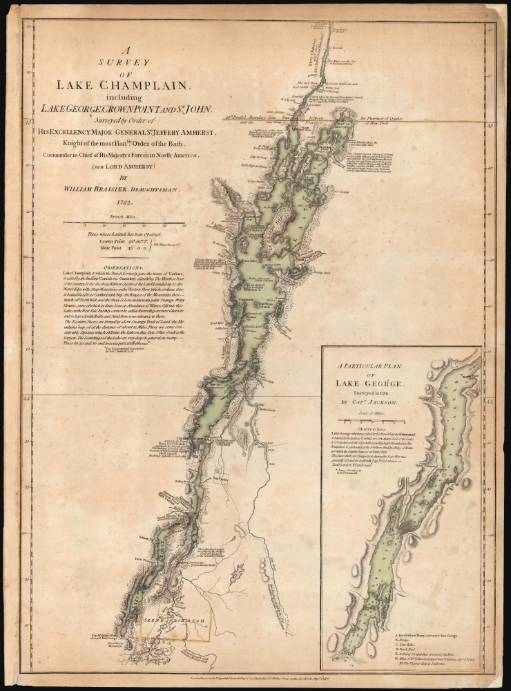
This is William Furness Brasier's 1762 map of Lakes Champlain and George, in its rare August 5, 1776, first state. It is the first separate map of Lake Champlain and Lake George. It would certainly have been in the hands of the British officers leading the Fall 1777 campaign during the American Revolutionary War (1775 - 1783), which culminated in the pivotal American victory at Saratoga. Most examples of this first state that we have seen on the market were issued in the so-called 'Holster Atlas,' and as such, exhibit significantly more folds and wear than this example, which appears to have been preserved in a larger-format book.
That is, there was no need until the outbreak of the American Revolution. At the time of the opening battles of Lexington and Concord, Fort Ticonderoga was a neglected, skeleton-crewed supply and communication link between Montreal and New York. On May 10, 1775, the fort was taken by American forces commanded by Ethan Allen and Benedict Arnold. The cannon captured by the Americans at Ticonderoga and magicked across the Massachusetts wilderness by Henry Knox broke the siege of Boston in March 1776. Even were it not for these indignities, General Burgoyne's plan to attack New York from Quebec the following year would underline the relevance of the region for the upcoming conflict. Thus, this edition printed by Sayer and Bennett in 1776.
First Detailed Map of Lake Champlain
The map is drawn from the surveys of William Brasier, assisted by Dietrich Brehm, who operated on behalf of the British Army throughout North America until the Revolution. They began their surveys as early as 1758, including around Fort Ticonderoga. Action in the area during the French and Indian War (1754 - 1763) prevented their conclusion in time to be of utility during that conflict. General Jeffrey Amherst urged Brasier to finish the job in 1762, resulting in the present map.The Map
Earlier maps distorted Lake Champlain. Even maps from the early 18th century saw this 'Lake of the Iroquois' misplaced far to the east. Here, it is mapped precisely for the first time, showing many islands and coastal features clearly, along with the topography of the shorelines. Lead mines and quarries - sites of great military value - are marked as well. The map includes a detailed map of Lake George, which bears such important features as Fort William Henry, lime kilns, and a brickyard. Fortifications are prominently noted throughout: not just forts William Henry and Ticonderoga but also Crown Point and Iroquois strongholds.Lake Champlain in the Montreal Campaign
The map also includes notes pertinent to the late conflict. Champlain was an important link connecting the Hudson River Valley with French strongholds in Quebec, and a force under the command of Lord Jeffrey Amherst moved to seize the lake and its forts as part of a pincer movement. The French had contested the lake against the British, but their commander, Jean de Laubaras, soon realized that his tiny fleet was cut off by a superior force and chose to scuttle his ships in 1759. This is noted just west of Grand Isle. On the northwest banks of Lake Champlain is noted a land engagement against the 'French and Indians' led by an American officer, Robert Rogers. His company, 'Rogers' Rangers,' had been attached to Lord Jeffrey Amherst's command in the Montreal Campaign. Amherst employed the Rangers primarily as raiders. The unit was one of those who participated in the siege of Île aux Noix further up the Richelieu River. That siege is referenced in a note regarding the Ile de Hopital. Hospital island, upstream of Île aux Noix - that is to say, to the south - is noted on the map as the place 'where the sick and Wounded were Carry'd during the Siege of Isle aux Noix and where Capn. Lt. Glegg of the Artillery was bury'd'. The newly captured forts of Crown Point, Fort William Henry, and Ticonderoga are all clearly noted.Prelude at Lake George
The inset map of Lake George - based on an earlier survey of 1756 (by a Captain Jackson, regarding whom the historical record is silent) - notes in particular the site of the Battle of Lake George (September 8, 1755) fought between the British and the French by forces led by William Johnson and the Baron de Dieskau, respectively. The British were reinforced by Iroquois allies, the French by Nipissing and Abenaki. Before Johnson's arrival at the lake that August, it had been known as Lac du Saint Sacrement - it was not until August 28 that it was renamed Lake George in honor of the English King. Johnson's victory over Dieskau placed the frontier with the French at the top of Lake George; had he been defeated, the frontier likely would have been Albany itself, and the later maneuvers recorded on the map might not have been able to take place.Drawn for the 'Last War,' Printed for the Next War
Brasier's work remained in manuscript after its 1762 completion. For the purposes of the war for which it was produced, it was too late. Although a treaty would wait until 1763, the war (with respect to the New York theatre) was over. By 1760, Montreal had fallen to the British. The British made peace with France's Cherokee allies in 1761; the last French attempt to retake Newfoundland failed in 1762. There was no longer any need for a map of Lakes Champlain and George to be published.That is, there was no need until the outbreak of the American Revolution. At the time of the opening battles of Lexington and Concord, Fort Ticonderoga was a neglected, skeleton-crewed supply and communication link between Montreal and New York. On May 10, 1775, the fort was taken by American forces commanded by Ethan Allen and Benedict Arnold. The cannon captured by the Americans at Ticonderoga and magicked across the Massachusetts wilderness by Henry Knox broke the siege of Boston in March 1776. Even were it not for these indignities, General Burgoyne's plan to attack New York from Quebec the following year would underline the relevance of the region for the upcoming conflict. Thus, this edition printed by Sayer and Bennett in 1776.
Publication History and Census
This first state of this map was first printed August 8, 1776, for inclusion in the Sayer and Bennett American Military Pocket Atlas (the 'Holster Atlas') and the American Atlas. It is apparent that it was issued unbound or in larger book formats as well: the present example does not exhibit the multiple folds usually seen on examples included in the Holster Atlas. This first state is rare: we see a single example listed in the collection of the British Library. The second state, including detail pertinent to the battle of Valcour Island, was published in October 1776. That map is reasonably well represented in institutional collections and appears on the market from time to time.CartographerS
William Furness Brasier or Brassier (1745-1772 or 1775) was a British surveyor operating in North America. His known work includes a 1756 map of the harbor of Antigua, 1759 plan of Oswego, a manuscript plan that same year of Fort Ticonderoga, and a 1761 plan of Detroit. He is best known for his 1762 map of Lakes Champlain and George. Little is known of his life, but from 1758 until his death he was one of the most talented surveyors of the British Army in North America, operating under the authority of General Lord Geoffrey Amherst. He was certainly a member of the Army's Corps of Engineers between 1757 and 1770; he appears also to have been appointed Deputy Surveyor to the Board of Ordnance. More by this mapmaker...
Robert Sayer (1725 - January 29, 1794) was an important English map publisher and engraver active from the mid to late 18th century. Sayer was born in Sunderland, England, in 1725. He may have clerked as a young man with the Bank of England, but this is unclear. His brother, James Sayer, married Mary Overton, daughter-in-law of John Overton and widow of Philip Overton. Sayer initially worked under Mary Overton, but by December of 1748 was managing the Overton enterprise and gradually took it over, transitioning the plates to his own name. When Thomas Jefferys went bankrupt in 1766, Sayer offered financial assistance to help him stay in business and, in this way, acquired rights to many of the important Jefferys map plates as well as his unpublished research. From about 1774, he began publishing with his apprentice, John Bennett (fl. 1770 - 1784), as Sayer and Bennett, but the partnership was not formalized until 1777. Bennett retired in 1784 following a mental collapse and the imprint reverted to Robert Sayer. From 1790, Sayer added Robert Laurie and James Whittle to his enterprise, renaming the firm Robert Sayer and Company. Ultimately, Laurie and Whittle partnered to take over his firm. Sayer retired to Bath, where, after a long illness, he died. During most of his career, Sayer was based at 53 Fleet Street, London. His work is particularly significant for its publication of many British maps relating to the American Revolutionary War. Unlike many map makers of his generation, Sayer was a good businessman and left a personal fortune and great estate to his son, James Sayer, who never worked in the publishing business. Learn More...
Source
Sayer, R., Bennett, J., and Jefferys, T., The American Atlas: Or, A Geographical Description Of The Whole Continent Of America ... Engraved On Forty-Eight Copper Plates, By The Late Mr. Thomas Jefferys, Geographer to the King, and Others, (London: Sayer and Bennett) 1776.
Thomas Jefferys' The American Atlas is among the most important atlases of American issued during and after the American Revolutionary War (1775 - 1783). Burden calls it 'arguably the first American 'state' atlas' and Ristow writes, it is a '… major cartographic reference work it was very likely consulted by American, English and French civilian administrators and military officers during the Revolution…' It was first published in 1775, with updates following in 1776, 1778, 1782, 1794, and 1800. All editions are notably postdate Jefferys himself, who died in 1771. The application of his name to the The American Atlas is mostly an honorific - though most of the constituent maps can be traced to Jefferys' work. After Jefferys' death, his map plates were acquired by his partner, printseller Robert Sayer. By the mid-1770s Sayer had taken on John Bennett as a partner. Together, they compiled and updated many of Jefferys' map, published as the to capitalize on interest in America associated with the Revolution. Maps from the The American Atlas exhbit is considerable date variation, with some featuring dates later than the title page, suggesting that many were updated by owners in subsequent years, and/or that the title page was reused for latter editions.
Condition
Very good. Recornered on upper and lower right, not impacting printed image. Few marginal mends. Else excellent with original wash and outline color.
References
OCLC 5571391 (second state). Rumsey 0875.006 (second state.) Tooley, R. Mapping of America p. 65, no. 25a. Nebenzahl, K.Atlas of the American Revolution pp. 61-63, no. 9. (second state.) Nebenzahl, A Bibliography of Printed Battle Plans of the American Revolution, no. 46. (second state).