1959 News-Journal Map of Lake Shasta and Environs
LakeShasta-newsjournal-1959$250.00


Title
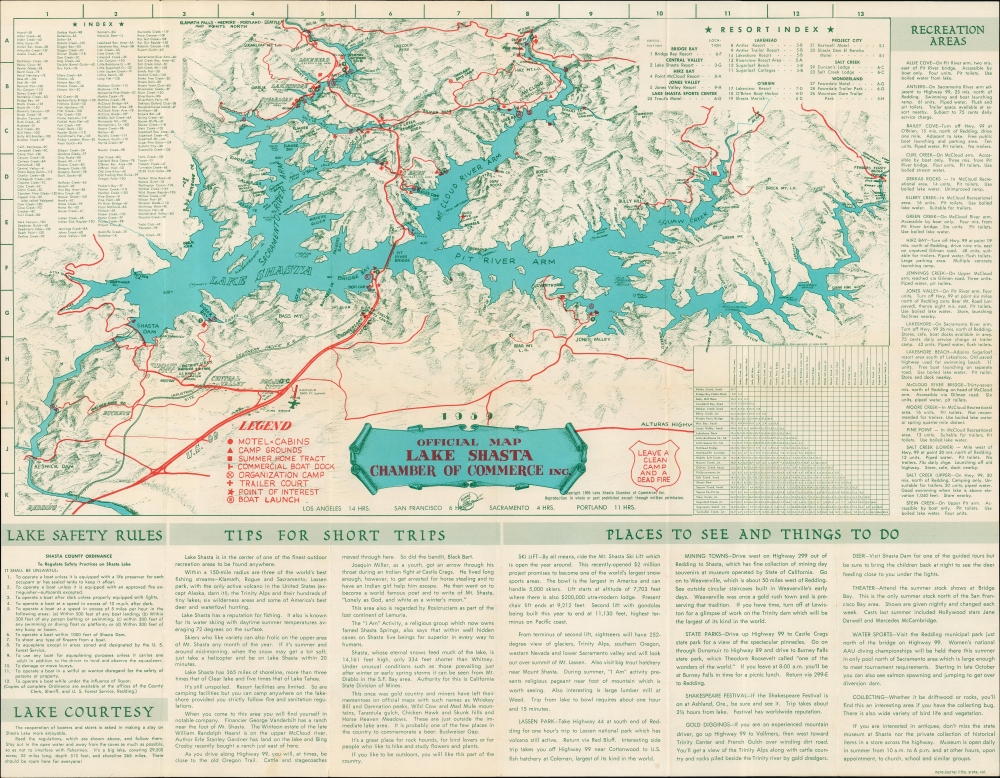
Official Map Lake Shasta / Lake Shasta and Shasta Dam Area in the Heart of the Shasta-Cascade Wonderland.
1959 (dated) 16.75 x 21.75 in (42.545 x 55.245 cm) 1 : 45000
1959 (dated) 16.75 x 21.75 in (42.545 x 55.245 cm) 1 : 45000
Description
A charming pictorial map of Lake Shasta and environs in northern California, printed in 1959 by the News-Journal Print Shop in Yreka for the Lake Shasta Chamber of Commerce.
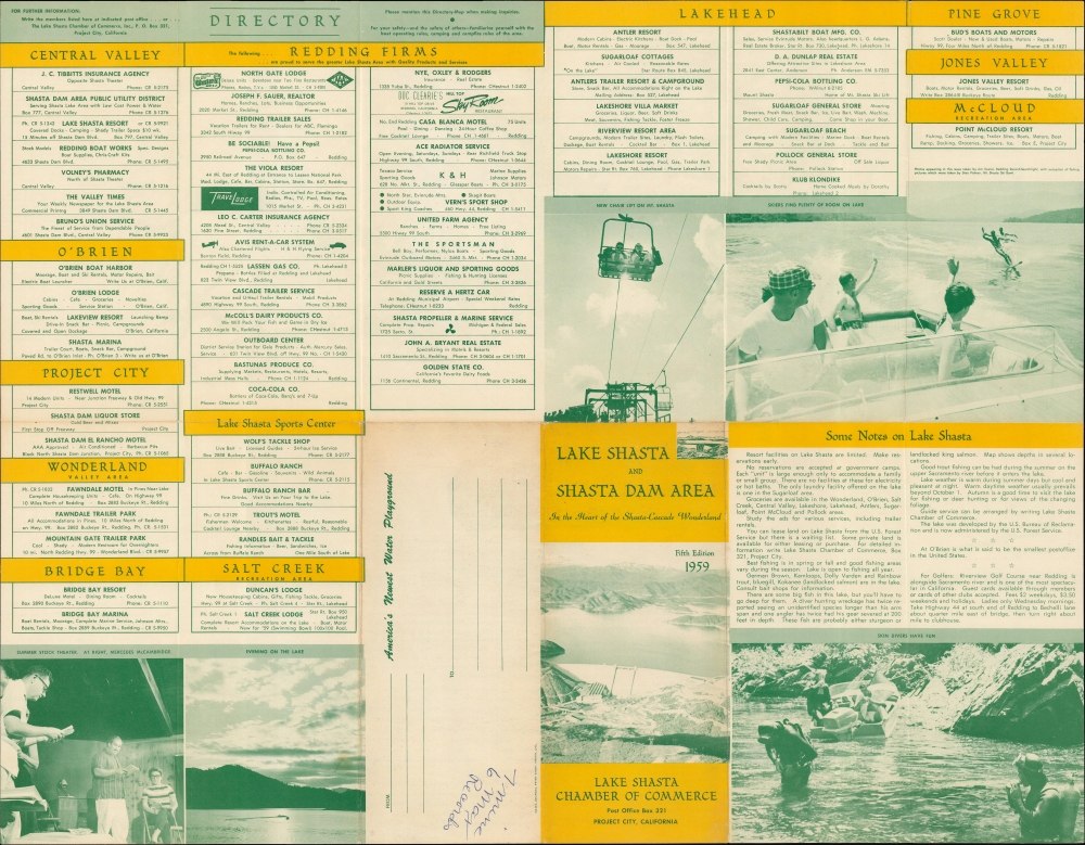
Many sites are numbered and listed in an index at left, located using a grid surrounding the map. A legend to the left of the title cartouche provides additional explanation. At top-right is an indexed list of resorts in the area, while at bottom-right is a table of distances by boat between different docks and maritime landmarks, including Shasta Dam. Tips, reminders, and information surround the map at right and bottom, including a full list of recreation areas. The verso includes photographs, promotional text, and a directory of businesses in towns and recreational areas around the lake.
A Closer Look
Lake Shasta, with its various arms, is highlighted, with landward features such as roads, railways, airfields, mountains, recreation areas, campsites, and more illustrated or labelled. Most noticeably, the highway U.S.-99 (later redesignated as Insterstate-5) and the lines of the Southern Pacific, which weaves in and out of tunnels, run roughly parallel north-south across the map. The two share the double-deck Pit River Bridge, completed in 1942, which serves as the 'mid-way point' of Interstate-5.Many sites are numbered and listed in an index at left, located using a grid surrounding the map. A legend to the left of the title cartouche provides additional explanation. At top-right is an indexed list of resorts in the area, while at bottom-right is a table of distances by boat between different docks and maritime landmarks, including Shasta Dam. Tips, reminders, and information surround the map at right and bottom, including a full list of recreation areas. The verso includes photographs, promotional text, and a directory of businesses in towns and recreational areas around the lake.
The Shasta Dam and Shasta Lake
Through both natural and manmade means, including the Shasta Dam and the resulting Shasta Lake, runoff from Mt. Shasta and other nearby mountains provides much of the freshwater for areas to the south, especially the Central Valley, an agricultural powerhouse. The dam, still one of the largest in the world, was an engineering marvel, considered the crowning achievement of the federal government's (Bureau of Reclamation) Central Valley Project when it was completed in 1945. As California's sources of freshwater have been imperiled in recent years by droughts and rising temperatures, proposals have been made to raise the dam to allow for greater storage of the abundant waters running off the mountains along the California-Oregon border, but environmental groups and the indigenous Wintun people, whose lands were almost completely flooded by the original dam project, have opposed these efforts.Publication History and Census
This pictorial map was drawn by 'Burns Signs,' an outfit we have been unable to find any information on, as noted below the title cartouche. It was printed by the News-Journal Print Shop in Yreka in 1959 for the Lake Shasta Chamber of Commerce. The map is only listed in the OCLC among the holdings of the California State Library. As indicated on the outside cover when folded (visible on the verso), this was the fifth edition of the map, though now is the earliest cataloged edition in institutional collections.Cartographer
News-Journal Print Shop (c. 1950 - 1966) was a lithographic printer based in Yreka, California. Its known output consists primarily of books dealing with local history and maps of cities and areas in northern California (namely Shasta and Siskiyou Counties). More by this mapmaker...
Condition
Very good. Light wear along original fold lines. Verso repair to a fold separation. Text and printed images on verso.
References
OCLC 180194285.