This item has been sold, but you can get on the Waitlist to be notified if another example becomes available, or purchase a digital scan.
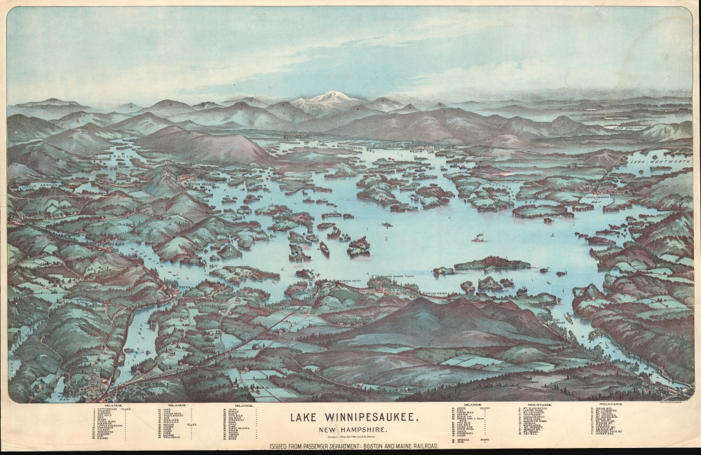
1903 Walker View of Lake Winnipesaukee, New Hampshire
LakeWinnipesaukee-walker-1903-2
Title
1903 (dated) 27.75 x 18 in (70.485 x 45.72 cm)
Description
A Closer Look
One of the more obscure and rare maps by George Walker, it covers the popular summertime destination from Little Asquam and Lake Winnesquam to Lake Wentworth and from Alton Bay and Round Bay to Moultonboro and Walkers Pond. The map includes many New Hampshire islands, towns, and bays, including Center Harbor, Asquam, Moultonboro, Wolfeboro, Lake Wentworth, Lake Ossipee, Long Bay, Meredith Bay, Alton Bay, Round Bay, and others. The White Mountains appear in the background, centered around a snow-covered Mt. Washington. The foreground features houses and fields with sailboats and steamships plying the lake. Fifty-nine islands and twenty-six mountains are included as keyed references along the bottom margin.Lake Winnipesaukee
When this map was issued, Lake Winnipesaukee was a thriving summer destination, attracting visitors from across New England and beyond. The largest in the state, Winnipesaukee was admired for its stunning natural beauty, with clear waters surrounded by rolling hills and forested mountains. From the late 1850s, the Boston and Maine Railroad had made the area more accessible, bringing a steady stream of tourists. Steamships, such as the famous Mount Washington, ferried visitors between lakeside resorts, islands, and attractions. The early 20th century marked a period of growth and prosperity for Lake Winnipesaukee, with hotels, cottages, and recreational facilities proliferating to accommodate increasing summer tourism.Boston and Maine Railroad
Commonly known as the 'B and M,' the Boston and Maine Railroad was chartered in New Hampshire on June 27, 1835. The firm consolidated several smaller companies, including the Andover and Haverhill Railroad and later the Boston and Portland Railroad. It merged with the Maine, New Hampshire, and Massachusetts Railroad in 1842 but retained the Boston and Maine operating name. In subsequent decades, it acquired or leased several other railroads, including the Boston and Lowell (1887), Northern (1884), Connecticut River (1893), Concord and Montreal (1887), and Fitchburg (1900). In 1897, it expanded service with the scenic Lake Shore Line, which ran along the southern shore of Lake Winnipesaukee. In 1910, it was acquired by J. P. Morgan and his New York, New Haven and Hartford Railroad. The firm initially prospered because of developing mill towns throughout New England and later capitalized on tourism from urban centers in Boston and New York. Nonetheless, the railroad declined during the Great Depression, when most of the old textile mills closed. Part of the Boston and Maine network remains in operation today under the Pan Am Railways (PAS) brand.Chromolithography
Chromolithography, sometimes called oleography, is a color lithographic technique developed in the mid-19th century. The process uses multiple lithographic stones, one for each color, to yield a rich composite effect. Generally, a chromolithograph begins with a black basecoat upon which subsequent colors are layered. Some chromolithographs used 30 or more separate lithographic stones to achieve the desired effect. Chromolithograph color can be blended for even more dramatic results. The process became extremely popular in the late 19th and early 20th centuries when it emerged as the dominant method of color printing. The vivid color chromolithography made it exceptionally effective for advertising and propaganda.Publication History and Census
This map was drawn and lithographed by George H. Walker in Boston on behalf of the Passenger Department of the Boston and Maine Railroad. This is the rare 1903 first edition, presentation format, issued to promote the Boston Maine Railroad's Lake Shore Branch. We note at least 4 examples of this edition in OCLC, but it is difficult to verify due to duplicate cataloging of the comparatively common folded editions.Cartographer
George Hiram Walker (January 4, 1852 - November 14, 1927) was a Boston based publisher of books, views, and maps active in the late 19th and early 20th centuries. Born in Springfield, Vermont, Walker started his life as a dry goods merchant but developed an active interest in publishing during the early 1870s. Walker began publishing in 1878 when he partnered with an unknown New York Firm. Two years later, Walker brought the operation in house by partnering with his brother, Oscar W. Walker, in the opening of a lithography studio at 81 Milk Street, Boston. Shortly thereafter the firm expanded to new offices at 160 Tremont Street, Boston. The Walker brothers produced a large corpus of works, most of which focused on travel and tourism in New England. Walker also established the Walker-Gordon Milk Laboratory with Dr. Thomas Morgan Rotch and Gustave Gordon. This interesting investment was based on the premise that infant deaths could be avoided by providing higher quality milk. The company eventually became a great success, producing a high-quality cow milk that closely resembled human breast milk. In the process the Walker-Gordon laboratory developed many of the dairy health standards that are still with us today. Walker married Irene L. Loud on March 25, 1885. More by this mapmaker...

