This item has been sold, but you can get on the Waitlist to be notified if another example becomes available, or purchase a digital scan.
1712 Wells Map of Central Italy in Antiquity
LatiumEtruria-wells-1712$175.00

Title
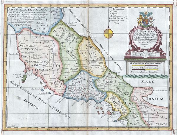
A New Map of Latium, Etruria, and as much of Antient Italy, as lay Between Gallia Cisalpina and Graecia Magna, Shewing their Principal Divisions, Cities, Towns, Rivers Mountains etc.
1712 (undated) 15 x 19.5 in (38.1 x 49.53 cm) 1 : 1450000
1712 (undated) 15 x 19.5 in (38.1 x 49.53 cm) 1 : 1450000
Description
This is a scarce 1712 map of central Italy in antiquity by Edward Wells of Oxford. It covers the region during the days of the Roman Empire from Gallia Cisalpine to Graecia Magna, noting towns, cities, rivers, mountains, islands and other topographical features. The map identifies a host of important cities and towns and uses ancient names throughout. The Roman regions of Latium, Etruria, Apulia and Campania are also noted.
Latium is the region of central western Italy in which the city of Rome was founded and grew to be the capital city of the Roman Empire. This land was originally where the tribe known as the Latins resided. Campania is a region in southern Italy that, during the Roman Era, was highly respected as a place of culture by the Emperors, where it balanced Greco-Roman culture.
During the first centuries of the Imperial Rome, Italia was the territory of the city of Rome rather than a Roman Province. As such Italia enjoyed a special status such that the armies of military commanders were not allowed into the region.
A decorative cartouche appears on the top right quadrant of the map featuring the coat of arms of the Duke of Gloucester. This, like many other Wells maps, is dedicated to Prince William, Duke of Gloucester and son of Queen Anne, who, when this map was being prepared, was a student at Oxford. Engraved by Sutton Nicholls and published by T. Bonwicke for the 1712 edition of Edward Wells' Atlas, A New Sett of Maps both of Ancient and Present Geography.
Cartographer
Edward Wells (1667 - 1727) was an English mathematician, geographer, and classical scholar based at Christ Church College, Oxford. Wells trained for the ministry but quickly found himself unsuited to religious life and instead applied for an academic position at Oxford, where he authored numerous well respected works on a wide range of mathematical and scientific topics. He tutored Prince William, the sickly son of Queen Anne, who was likely about 11 at the time this map was prepared. Wells dedicated nearly all of the maps in his atlas, A New Sett of Maps both of Ancient and Present Geography, to the young prince - quite possibly posthumously, as William died in July of 1700 shortly prior to the publication of the atlas. Nonetheless, Wells' geography proved popular and was published in number editions well into the 1730s. More by this mapmaker...
Source
Wells, E., A New Sett of Maps both of Ancient and Present Geography, (London, T. w. Bonwicke) c. 1712.
A New Sett of Maps both of Ancient and Present Geography was published by Edward Wells in various editions between 1701 and 1730. The publication contained some 40 maps all of which were dedicated to Prince William, Duke of Gloucester. Wells tutored the young prince at Christchurch, Oxford and seems to have developed a close relationship with him. At just 11 years of age, William died in 1700 and never had the opportunity to see the published work that he inspired. The atlas was intended for educational purposes with a focus on school use.
Condition
Very good. Some creasing and toning along original centerfold. Minor spotting.
References
OCLC Number: 11807155.