This item has been sold, but you can get on the Waitlist to be notified if another example becomes available, or purchase a digital scan.
1944 Chapin Map of Central Italy Just After the Allied Landing at Anzio in WWII
LeftFlank-chapin-1944$187.50

Title
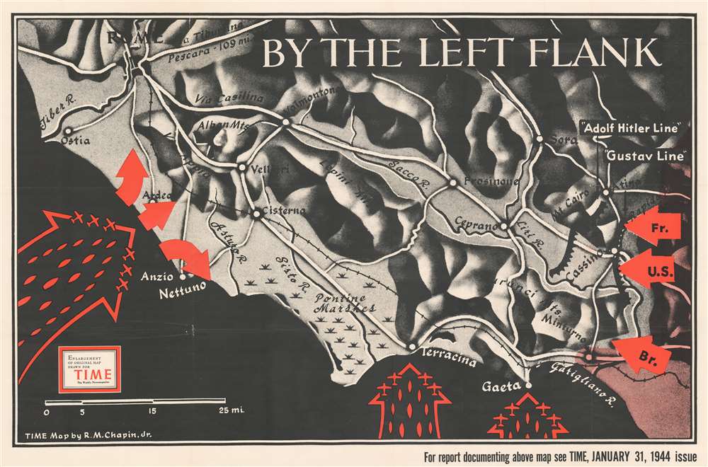
By the Left Flank.
1944 (dated) 28 x 42.5 in (71.12 x 107.95 cm) 1 : 144000
1944 (dated) 28 x 42.5 in (71.12 x 107.95 cm) 1 : 144000
Description
This is a 1944 Robert M. Chapin, Jr. map of central Italy the week after the Allied landing at Anzio. The map depicts the region from the Mediterranean Sea to Atina and Sora and from Rome to Miturno and Cassino. Red icons are used to mark the Allied landing at Anzio, which took place on January 22, 1944, in an effort to break the stalemate along the German 'Gustav Line' at Cassino. Barbed lines highlight the German's fortified positions in front of the advancing American, British, and French troops who had been advancing north from Salerno since September 1943. Roads are illustrated in white, with the regions rivers also noted.
Operation Shingle - the Amphibious Landings at Anzio
By November 1943, it was obvious that a stalemate existed along the Gustav Line halfway between Salerno and Rome. The Allied commander in chief of the Italian Campaign, British General Sir Harold Alexander, decidedthat yet another amphibious landing would be necessary to break the stalemate and it was set for January 1944. Two augmented infantry divisions were deemed necessary, to which historian Samuel Eliot Morison retorted, 'Either it was a job for a full army, or it was no job at all; to attempt it with only two divisions was to send a boy on a man's errand'. The landings, which had weeks of inauspicious preparations, went off smoothly on the morning of January 22, 1944, and were mostly unopposed. Allied troops managed to push a few miles inland and set a perimeter around the beachhead. By the end of the first day, over 36,000 men and 3,000 vehicles had been landed. But that easy success was not to last, as within two days later the Germans had regrouped and savagely counterattacked, pushing the American and British troops back to within sight of the beach. Here, yet another stalemate began, and lasted from the beginning of February until the end of May, when the Allies finally broke through the Gustav Line and the Germans were forced to withdraw north of Rome, which was liberated on June 4, 1944.Publication History and Census
This map was drawn by Robert M. Chapin, Jr. to accompany an article in TIME Magazine which was published in the January 31, 1944 issue. TIME subsequently published this edition of the map separately. The OCLC records two examples as being part of the institutional collections at Franklin and Marshall College and Wichita State University.Cartographer
Robert M. Chapin Jr. (fl. 1933 - 1970) was a prominent architect, cartographer and illustrator active during World War II and the Cold War. Chapin graduated from the University of Pennsylvania in 1933 with a degree in architecture. Since this was the height of the Great Depression, and architects in low demand, he instead took work as a staff cartographer at Newsweek. Catching the attention of Manfred Gottfried of Time, Chapin was offered an accepted a position at the head of Time's cartography department. He remained with Time for some 33 years, from 1937 to 1970, often drawn 2 - 3 new thematic maps weekly. With an architect's gift visualizing information, Chapin became a skilled informational cartographer, heading the cartography department at Time Magazine. Chapin, like Fortune Magazine chief cartographer, Richard Edes Harrison, Chapin was at the forefront of infographic propaganda cartography, a genre that matured during the World War II Era and remains popular today. Working for Time Magazine, Chapin developed a signature style for his long run of 'War Maps.' Chapin was known for his maverick airbrush technique which lead to strong color splashes and intense shading. He also incorporated celluloid stencils to illustrate bomb explosions, flags, sinking ships, and more - generating a instantly recognizable standardized style. Chapin's Time war maps were further distinctive for their use of strong bold reds as a universal symbol of hostility. Chapin graduated from the University of Pennsylvania in 1933 with a degree in architecture. Since this was the height of the Great Depression, an d architects in low demand, he instead took work as a staff cartographer at Newsweek. Catching the attention of Manfred Gottfried of Time, Chapin was offered an accepted a position at the head of Time's cartography department. He remained with Time for some 33 years, from 1937 to 1970, often drawn 2 - 3 new thematic maps weekly. Chapin live in Sharon Connecticut. More by this mapmaker...
Condition
Very good. Even overall toning. Verso repairs to fold separations and at fold intersections. Closed tear extending 2.5 inches into printed area from top margin professionally repaired on verso. Blank on verso. Has old institutional collection stamp on verso. We have contacted the institution to verify that this item was legally deaccessioned.
References
OCLC 47735305.