1639 Merian Plan of the 1637 Siege of Leipzig
LeipzigSiege-merian-1639$450.00

Title
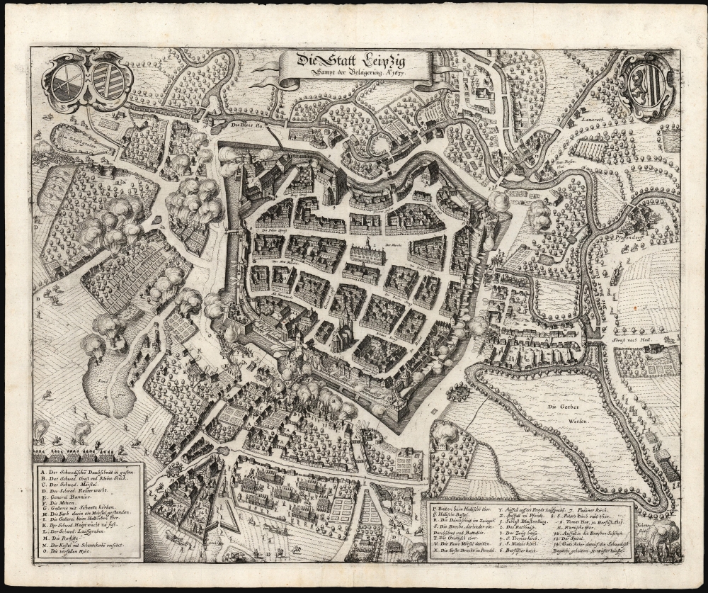
Die Statt Leipzig Sampt der Belagerung. Ao. 1637.
1639 (undated) 8 x 12.5 in (20.32 x 31.75 cm) 1 : 8500
1639 (undated) 8 x 12.5 in (20.32 x 31.75 cm) 1 : 8500
Description
This is Matthäus Merian's superbly detailed 1639 plan of the city of Leipzig, under siege by the Swedish army during the Thirty Years' War (1618 - 1648). The plan captures the walled and moated city and its suburbs in the midst of battle. Whole neighborhoods are in flames with Swedish positions around the city revealed, presenting the most desperate point of the siege: the Swedes had blown a huge breach at the Grimma Gate, and were on the verge of taking the town.
A Closer Look
The walled city and its suburbs are vividly portrayed. Thirty-seven key structures - primarily churches and forts, but also troop movements and even the Swedish general himself - are letter-and-number-keyed to a legend at the bottom of the view.1637 Siege of Leipzig
Swedish forces, led by their famous general Johan Banér, were not actually in a strong position. Their supply lines had been cut, and they had been ranging around Saxony relying on forage. Attacking the capital of Saxony was a desperate move, and despite the apparent near success of the gambit, news arrived that a fresh Imperial army was close to encircling the Swedes. No sooner had the city walls been breached, that the Swedes had to pick up their wounded and withdraw.Thirty Years' War
The Thirty Years' War (1618 - 1648), was one of the most destructive conflicts in European history, resulting in significant political, religious, and social upheaval. Originating as a religious feud between Catholic and Protestant states within the Holy Roman Empire, the conflict quickly expanded, drawing in most of the major European powers of the time. While the war began primarily as a religious dispute, its motives evolved over the years, driven by dynastic ambitions, territorial gains, and political supremacy. The war devastated much of Central Europe, especially the German-speaking territories, with vast civilian casualties and economic disruption. The Peace of Westphalia, which concluded the war in 1648, led to significant shifts in territorial boundaries and set the precedent for state sovereignty in international relations.Publication History and Census
This view was created by Matthaus Merian and appeared in his 1639 Theatrum Europaeum. We see four examples of the plan listed in OCLC; the Theatrum is well represented in institutional collections.Cartographer
Matthäus Merian (September 22, 1593 - June 19, 1650), sometimes referred to as 'the Elder' to distinguish from his son, was an important Swiss engraver and cartographer active in the early to mid 17th century. Merian was born in Basel and studied engraving in the centers of Zurich, Strasbourg, Nancy and Paris. In time Merian was drawn to the publishing mecca of Frankfurt, where he met Johann Theodor de Bry, son of the famed publisher Theodor de Bry (1528 - 1598) . Merian and De Bry produced a number of important joint works and, in 1617, Merian married De Bry's daughter Maria Magdalena. In 1623 De Bry died and Merian inherited the family firm. Merian continued to publish under the De Bry's name until 1626. Around this time, Merian became a citizen of Frankfurt as such could legally work as an independent publisher. The De Bry name is therefore dropped from all of Merian's subsequent work. Of this corpus, which is substantial, Merian is best known for his finely engraved and highly detailed town plans and city views. Merian is considered one of the grand masters of the city view and a pioneer of the axonometric projection. Merian died in 1650 following several years of illness. He was succeeded in the publishing business by his two sons, Matthäus (1621 - 1687) and Caspar (1627 - 1686), who published his great works, the Topographia and Theatrum Europeaum, under the designation Merian Erben (Merian Heirs). Merian's daughter, Anna Maria Sibylla Merian, became an important naturalist and illustrator. Today the German Travel Magazine Merian is named after the famous engraver. More by this mapmaker...
Source
Merian, M., Theatrum Europaeum, (Frankfurt am Main) 1639.
Condition
Excellent. Centerfold reinforced in margin not impacting printed image.
References
OCLC 1270908161.