This item has been sold, but you can get on the Waitlist to be notified if another example becomes available, or purchase a digital scan.
1771 Bonne Map of Persia ( Iran, Iraq, Afghanistan )
LEmpireDePerse-bonne-1771$100.00

Title
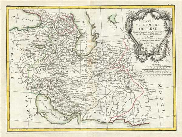
Carte de L'Empire de Perse.
1771 (dated) 13 x 17.5 in (33.02 x 44.45 cm) 1 : 7600000
1771 (dated) 13 x 17.5 in (33.02 x 44.45 cm) 1 : 7600000
Description
A beautiful example of Rigobert Bonne's 1771 decorative map of the Persia. Covers from the Black Sea south to the Persian Gulf and east past the Caspian Sa to the Indus Valley. Includes the modern day nations of Iran, Iraq, Kuwait, Afghanistan, Georgia, Armenia, Azerbaijan, with parts of adjacent Turkey, Saudi Arabia, and Pakistan. Names numerous tribal areas, villages, cities, deserts, caravan routes, and river systems.
Persia at this time was itself experiencing the waning years of the short lived Zand Dynasty who ruled from the capital city of Isfahan - identified here. Within 50 years of this maps issue, in 1794, Aga Muhammad Khan would overthrow Loft Ali Khan, last Shah of the Zand Dynasty, and relocate the capital to the new city of Tehran. The subsequent era, the Qajar Dynasty, witnessed numerous military conflicts with the rising powers of Imperial Russia and the loss of much of Persia's territory.
A large decorative title cartouche bearing garlands appears in the upper right hand quadrant. A fine map of the region. Drawn by R. Bonne in 1771 for issue as plate no. B 25 in Jean Lattre's Atlas Moderne.
CartographerS
Rigobert Bonne (October 6, 1727 - September 2, 1794) was one of the most important French cartographers of the late 18th century. Bonne was born in Ardennes à Raucourt, France. He taught himself mathematics and by eighteen was a working engineer. During the War of the Austrian Succession (1740 - 1748) he served as a military engineer at Berg-op-Zoom. It the subsequent years Bonne became one of the most respected masters of mathematics, physics, and geography in Paris. In 1773, Bonne succeeded Jacques-Nicolas Bellin as Royal Cartographer to France in the office of the Hydrographer at the Depôt de la Marine. Working in his official capacity, Bonne compiled some of the most detailed and accurate maps of the period - most on an equal-area projection known erroneously as the 'Bonne Projection.' Bonne's work represents an important step in the evolution of the cartographic ideology away from the decorative work of the 17th and early 18th century towards a more scientific and practical aesthetic. While mostly focusing on coastal regions, the work of Bonne is highly regarded for its detail, historical importance, and overall aesthetic appeal. Bonne died of edema in 1794, but his son Charles-Marie Rigobert Bonne continued to publish his work well after his death. More by this mapmaker...
Jean Lattré (170x - 178x) was a Paris based bookseller, engraver, globe maker, calligrapher, and map publisher active in the mid to late 18th century. Lattré published a large corpus of maps, globes, and atlases in conjunction with a number of other important French cartographic figures, including Janvier, Zannoni, Bonne and Delamarche. He is also known to have worked with other European cartographers such as William Faden of London and the Italian cartographer Santini. Map piracy and copyright violations were common in 18th century France. Paris court records indicate that Lattré brought charges against several other period map publishers, including fellow Frenchman Desnos and the Italian map engraver Zannoni, both of whom he accused of copying his work. Lattré likes trained his wife Madame Lattré (né Vérard), as an engraver, as a late 18th century trade card promotes the world of 'Lattré et son Epouse.' Lattré's offices and bookshop were located at 20 rue St. Jaques, Paris, France. Later in life he relocated to Bordeaux. Learn More...
Source
Lattre, Jean, Atlas Moderne ou Collection de Cartes sur Toutes les Parties du Globe Terrestre, c.1778.
Condition
Very good. Some toning and wear along original centerfold. Minor foxing. Original platemark visible.
References
Rumsey 2612.051. Phillips (Atlases) 664. National Maritime Museum, 215.