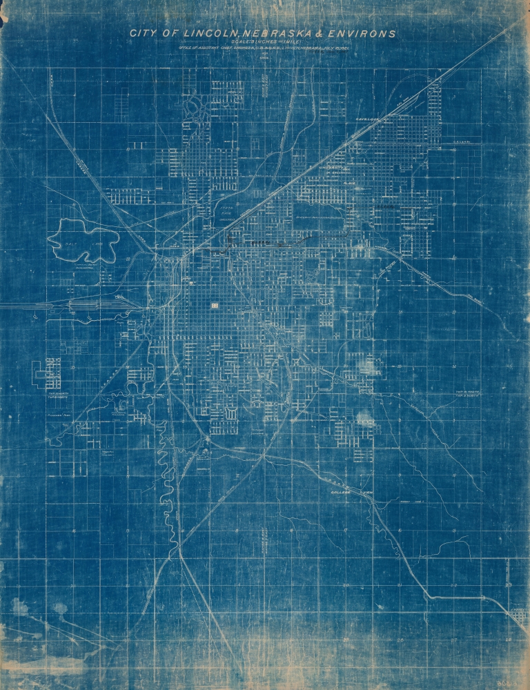
1921 Chicago, Burlington and Quincy Railroad City Plan or Map of Lincoln, Nebraska
LincolnNebraskaEnvirons-cbqrr-1921$500.00


Title
City of Lincoln, Nebraska and Environs.
1921 (dated) 38 x 29 in (96.52 x 73.66 cm) 1 : 190080
1921 (dated) 38 x 29 in (96.52 x 73.66 cm) 1 : 190080
Description
This is a 1921 Chicago, Burlington and Quincy Railroad city map of Lincoln, Nebraska. The map was issued in the heady days following World War I (1914 - 1918) and bustled with the broader currents of the Roaring Twenties. During this period Lincoln's downtown expanded with a mix of new infrastructure, businesses, and cultural institutions, reflecting a vibrant urban scene.
A Closer Look
Depicting from Fletcher Avenue south to Cheney, Nebraska, (labeled here as Cheneys) and from Pioneers Park east to Cheney, the map presents Lincoln in detail. Streets are illustrated and labeled throughout. Both the City Campus and the East Campus (labeled here as the State Univ. Agricultural College) of the University of Nebraska are identified and Lincoln High School is labeled. Nebraska Wesleyan University's campus appears as well. Among the railroads illustrated are the Chicago, Burlington and Quincy Railroad; the Chicago and Northwestern Railway; the Chicago, Rock Island and Pacific Railway; the Missouri Pacific Railroad, and the Union Pacific Railroad.Manuscript Notations
Surprisingly detailed manuscript notations highlight the rail network of the Omaha, Lincoln and Beatrice Railway. Spur lines, the railway's rail yard, and its sidings are all illustrated in black. The Omaha, Lincoln, and Beatrice never made it outside of Lincoln, but remains in operation today as a private Class III switching railroad.Cyanotype: Why so Blue?
Cyanotype is a photo-reprographic technique developed in 1842 by the British astronomer John Herschel (1792 - 1871). Sometimes called a 'sunprint', the technique employs a solution of ferric ammonium citrate and potassium ferricyanide, which painted on white paper or cloth, reacts when exposed to sunlight to dye the object a brilliant blue. Areas blocked from ultraviolet exposure remain undyed and white. Herschel developed the technique to reproduce his astronomical notes, but others quickly realized that any object capable of blocking light could be used to create a cyanotype image quickly and easily. By the late 19th century, the process became popular with designers, military, architects, and engineers (blueprints), who used the cheap and effective technique to quickly and exactly reproduce images in the field. Cyanotyping is limited in that only a single copy can be made at one time, so it was only practical for short-term field work. It is also of note that cyanotypes remain extremely reactive to light and, over time, fade or degrade, making them extremely ephemeral. The process fell out of fashion in most places by the 1920s but remains in use in some parts of the world, such as India and Nepal, to this day.Publication History and Census
This map was created by the Chicago, Burlington and Quincy Railroad and published on July 15, 1921. The present example features manuscript additions highlighting the rail lines of the Omaha, Lincoln and Beatrice Railway dating to June 11, 1947. This is the only known surviving example.Condition
Good. Discoloration to top and bottom edges. Manuscript pen depiction of Omaha, Lincoln and Beatrice Railroad. Close right margin, likely as issued.