This item has been sold, but you can get on the Waitlist to be notified if another example becomes available, or purchase a digital scan.
1899 Lindrooth Map of Lincoln Park, Chicago
LincolnParkChicago2-lindrooth-1899$250.00

Title
Lincoln Park, Chicago, Ill, 1899.
1899 (dated) 7.5 x 22 in (19.05 x 55.88 cm) 1 : 5400
1899 (dated) 7.5 x 22 in (19.05 x 55.88 cm) 1 : 5400
Description
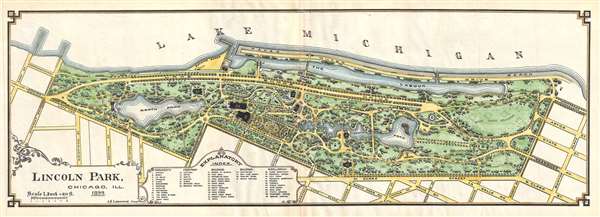
This is an 1899 J. H. Lindrooth map of Lincoln Park, Chicago. The map depicts Lincoln Park from Lake Michigan to N. Clark Street and from Surf Street and Diversity Boulevard to Burton Place. Forty-nine sites are listed throughout the park, including several monuments and fountains and both the large and small animal house at the zoo. Other, more practical sites, include water fountains, men's and women's restrooms, picnic grounds, and tennis courts. Swan Island and a duck pond are also indicated.
This map was drawn by J. H. Lindrooth for inclusion in the 1899 Report of the Commissioners and a history of Lincoln Park.
This map was drawn by J. H. Lindrooth for inclusion in the 1899 Report of the Commissioners and a history of Lincoln Park.
Cartographer
J. H. Lindrooth (September 9, 1840 - October 12, 1912) was a Chicago based civil engineer, surveyor, and draughtsman active in the late 19th and early 20th century. Lindrooth was born in Sweden before immigrating to the United States as a young man. He set up in Chicago where he was naturalized as a United States Citizen in 1872. He married Anna Elizabeth Erickson in 1869 and fathered 6 children. Lindrooth was deeply involved with the planning and construction of Lincoln Park, Chicago from about 1869 onwards. More by this mapmaker...
Source
Bryan, I. J., Report of the Commissioners and a history of Lincoln Park, (Chicago) 1899.
Condition
Very good. Slight wear along original centerfold. Even overall toning. Blank on verso.
References
Newberry Library, G 8960 .16 p. [98-99] (PrCt).