This item has been sold, but you can get on the Waitlist to be notified if another example becomes available, or purchase a digital scan.
1756 Bellin View and Map of Lisbon, Portugal
Lisbonne-bellin-1756$475.00

Title
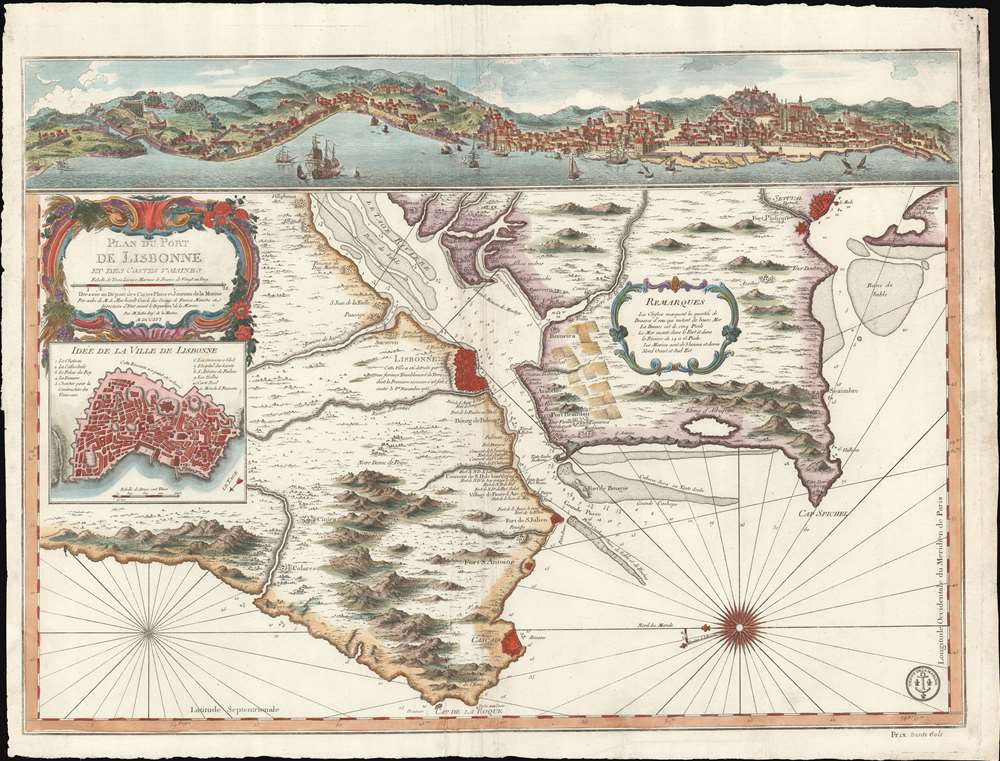
Plan du Port de Lisbonne et es Costes Voisines.
1756 (dated) 19 x 25 in (48.26 x 63.5 cm) 1 : 220000
1756 (dated) 19 x 25 in (48.26 x 63.5 cm) 1 : 220000
Description
A scarce 1756 J. N. Bellin nautical map of Lisbon, reflecting the aftermath of the disastrous 1755 mega-earthquake that all but destroyed golden-age Lisbon and the surrounding lands. Oriented to the East - as a ship world approach the Tage - the map depicts the city of Lisbon and entrances to the port on both sides of the Tage River, extending south to Setuval and north beyond Colares. A dramatic view of Lisbon as it would have appeared just before the earthquake surmounts the map. An inset near the rococo title cartouche details the walled city of Lisbon - as it appeared before the quake, but as this is primarily a nautical chart, such would not have affected navigation.
In the end, 85% of the city was in ruins and some 40,000 people (of the city's 200,000) died. The famed palaces and libraries were destroyed, including the Royal Archives, which housed hundreds of priceless paintings by the great masters of Europe. Also lost, and of note to us, were all the records of early Portuguese navigation, including those of Vasco de Gama, Pedro Álvares Cabra, and Bartolomeu Dias.
In an instant, the thriving Portuguese economy collapsed. Having struck on a religious holiday, many staunch Catholics believed the quake to be Divine wrath. The earthquake also had a wide-ranging impact on philosophy and literature throughout Europe. It was used by some to argue against the notion of a benevolent deity. Politically, the aftermath precipitated a consolidation of power in the hands of the king and the fall of many of Portugal's long-standing noble families.
Great Lisbon Earthquake
In 1755, Lisbon was at the height of its Golden Age. Portuguese ships sailed from Lisbon to all parts of the world: to its colonies in Brazil, or to Macao, India, and Africa. Monarchs lavished wealth on their capital, making it a city of soaring cathedrals and palaces. Then, the Portuguese Golden Age came crashing to an end on November 1, 1755, when a massive earthquake (est. 7.7 on the Richter Scale) devastated Lisbon. Fleeing collapsing buildings, the populace fled to open spaces, only to watch the sea recede, destroying all ships and cargo in the harbor. Forty minutes later, three massive tsunamis crashed into the already devastated city. As November 1 was All Saints Day, devotional candles throughout the city were toppled, leading to a firestorm of such magnitude that it asphyxiated people up to 30 meters from the flames.In the end, 85% of the city was in ruins and some 40,000 people (of the city's 200,000) died. The famed palaces and libraries were destroyed, including the Royal Archives, which housed hundreds of priceless paintings by the great masters of Europe. Also lost, and of note to us, were all the records of early Portuguese navigation, including those of Vasco de Gama, Pedro Álvares Cabra, and Bartolomeu Dias.
In an instant, the thriving Portuguese economy collapsed. Having struck on a religious holiday, many staunch Catholics believed the quake to be Divine wrath. The earthquake also had a wide-ranging impact on philosophy and literature throughout Europe. It was used by some to argue against the notion of a benevolent deity. Politically, the aftermath precipitated a consolidation of power in the hands of the king and the fall of many of Portugal's long-standing noble families.
Publication History and Census
This map was compiled by Jacques Nicholas Bellin and published in Paris by the French Dépôt des Cartes et Plans de la Marine. It was first issued, as here in 1756, one year after the 1755 Great Lisbon Earthquake redefined regional geography. The map is scarce. The OCLC has multiple entries for this map, but these can be distilled into just 4 cataloged examples: the British Library, the University of Chicago, the Biblioteca Nacional de España, and the Bibliothèque Nationale de France. It appears only rarely on the market.CartographerS
Jacques-Nicolas Bellin (1703 - March 21, 1772) was one of the most important cartographers of the 18th century. With a career spanning some 50 years, Bellin is best understood as geographe de cabinet and transitional mapmaker spanning the gap between 18th and early-19th century cartographic styles. His long career as Hydrographer and Ingénieur Hydrographe at the French Dépôt des cartes et plans de la Marine resulted in hundreds of high quality nautical charts of practically everywhere in the world. A true child of the Enlightenment Era, Bellin's work focuses on function and accuracy tending in the process to be less decorative than the earlier 17th and 18th century cartographic work. Unlike many of his contemporaries, Bellin was always careful to cite his references and his scholarly corpus consists of over 1400 articles on geography prepared for Diderot's Encyclopedie. Bellin, despite his extraordinary success, may not have enjoyed his work, which is described as "long, unpleasant, and hard." In addition to numerous maps and charts published during his lifetime, many of Bellin's maps were updated (or not) and published posthumously. He was succeeded as Ingénieur Hydrographe by his student, also a prolific and influential cartographer, Rigobert Bonne. More by this mapmaker...
Dépôt des Cartes et Plans de la Marine (fl. 1720 - present), often called the Dépôt de Marine, was a French hydrographic mapping organization founded in 1720 under Charles-Hercule of Albert de Luynes (1674 - 1734). Much like the U.S. Coast Survey, the British Admiralty, and the Spanish Deposito Hydrografico, the Dépôt was initiated as a storehouse and distribution center of existing nautical and marine charts. Eventually the Dépôt initiated its own mapping activities in an attempt to improve and expand upon existing material. Some of the more prominent cartographers and hydrographers associated with the of Dépôt des Cartes were, Philippe Buache, Jacques-Nicholas Bellin, Giovanni Rizzi-Zannoni, Rigobert Bonne, and Jean Nicolas Buache. Learn More...
Condition
Very good. Wear along original centerfold.
References
OCLC 58996400.