This item has been sold, but you can get on the Waitlist to be notified if another example becomes available.
1975 Vaughn Surber Gray Pictorial Map of Litchfield County, Connecticut
Litchfield-vaughn-1975$75.00

Title
Litchfield County, Connecticut.
1975 (dated) 22 x 22 in (55.88 x 55.88 cm) 1 : 120000
1975 (dated) 22 x 22 in (55.88 x 55.88 cm) 1 : 120000
Description
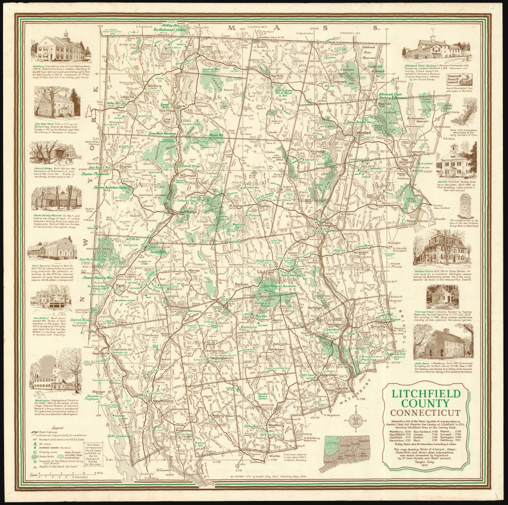
This is an attractive, 1975 Vaughn Surber Gray pictorial map of bucolic Litchfield County, in northwestern Connecticut. The map is bordered by Massachusetts and New York to the north and west, with the counties of Hartford, New Haven, and Fairfield bordering the east and south.
The border decorative elements are presented in the style of county maps of the previous centuries, illustrating notable landmark structures: Salisbury Town Hall, the Gay-Hoyt House, the West Cornwall covered bridge, the Sloane-Stanley Museum, the Kent Memorial Library, the New Milford band stand, the Washington Congregational Church, the Hitchcock Chair Factory, the state's old turnpike, and traditional New England stone walls that line the area are depicted, among other features.
The map was intended for tourists as an advertiser for local trade (a directory of subscribing businesses appears on the verso.) The overall presentation is nostalgic, emphasizing the historic and picturesque nature of the county and detailing its colonial and American Revolutionary War (1775 - 1783) history. The map's 'ye olde' presentation extends to the mapmaker's signature, 'Yr. most Humble and Obedt servant, Vaughn Gray'.
A Closer Look
Cartographically, it is modern in execution, with towns and cities in the county labeled, as well as mountains, ponds, lakes, rivers, and wetlands. Roads are distinguished by their quality, and state parks, forests, ski areas, camps, and nature conservancy areas are marked. Features are explained in a detailed legend at the bottom left.The border decorative elements are presented in the style of county maps of the previous centuries, illustrating notable landmark structures: Salisbury Town Hall, the Gay-Hoyt House, the West Cornwall covered bridge, the Sloane-Stanley Museum, the Kent Memorial Library, the New Milford band stand, the Washington Congregational Church, the Hitchcock Chair Factory, the state's old turnpike, and traditional New England stone walls that line the area are depicted, among other features.
The map was intended for tourists as an advertiser for local trade (a directory of subscribing businesses appears on the verso.) The overall presentation is nostalgic, emphasizing the historic and picturesque nature of the county and detailing its colonial and American Revolutionary War (1775 - 1783) history. The map's 'ye olde' presentation extends to the mapmaker's signature, 'Yr. most Humble and Obedt servant, Vaughn Gray'.
Publication History and Census
This map was drawn by Vaughn Surber Gray, and published for him by Kent Stationery. Examples are listed in the collections of the Connecticut Museum of Culture and History, Illinois University, and the Library of Congress.Cartographer
Vaughn Surber Gray (November 26, 1911 - August 12, 1994) was an American artist. He was born in Indiana, but soon moved to western Massachusetts with his family. Little is known of his background, but by 1940 he was living in New York City and working as a newspaper artist. A significant portion of his work appears to have been maps, mainly produced for the tourist or advertising markets, predominantly in western Massachusetts. He died in Great Barrington in 1994. More by this mapmaker...
Condition
Very good. Mended tack holes in corners, not impacting printed image.
References
OCLC 5444650.