This item has been sold, but you can get on the Waitlist to be notified if another example becomes available, or purchase a digital scan.
1885 Kelly Postal Map of London, England
London-kelly-1885$225.00

Title
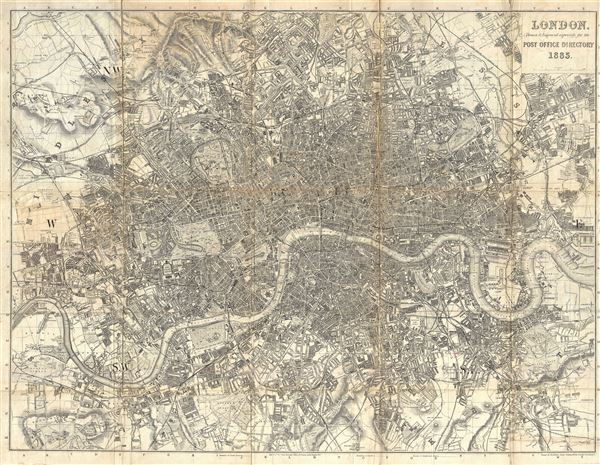
London. Drawn and Engraved expressly for the Post Office Directory 1885.
1885 (dated) 28.5 x 36.5 in (72.39 x 92.71 cm) 1 : 21120
1885 (dated) 28.5 x 36.5 in (72.39 x 92.71 cm) 1 : 21120
Description
A large 1885 dissected folding map of London by Kelly and Company. Issued for the Kelly and Co. Post Office Directory, this large map covers from Highgate to Plaistow and from Dulwich to Chiswick. The map offers stupendous detail throughout identifying important streets, parts, squares, rail lines, and in many cases individual building lots. Limited topography is rendered in hachure. Kelly and Company first published this map in 1859, subsequent to which it was presented in 34 editions until 1890. The present example is the 28th edition.
Condition
Good. Map exhibits some discolorations, wear, and toning on original fold lines. The map has been dissected and mounted on linen for effective folding and unfolding.
References
Hyde, Ralph, Printed Maps of Victorian London, 1851 - 1900, no. 61-28.