This item has been sold, but you can get on the Waitlist to be notified if another example becomes available, or purchase a digital scan.
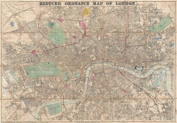
1873 Whitbread Folding Map of London, England
London-whitbread-1873$225.00

Title
Whitbread's Reduced Ordnance Map of London.
1873 (dated) 22.5 x 32.5 in (57.15 x 82.55 cm) 1 : 16800
1873 (dated) 22.5 x 32.5 in (57.15 x 82.55 cm) 1 : 16800
Description
A very attractive large map of London, England, published by Whitbread in 1873. As this title suggests, this map was reduced from the Ordnance Survey for the consumer market. The map covers from the West End around Edgeware Road to Parcens Garden, Victoria Park, and New Cross. Identifies all streets, parks, railway lines, railroad stations, important buildings, and piers. Whitbread first issued this map in 1867. Hyde identifies eight known editions with the present example being the 4th, wherein the Great Eastern Railroad is extended to Liverpool Street Station.
CartographerS
Josiah Whitbread (fl. c. 1864 – 1879) was a London based map publisher active in the middle to later parts of the 19th century. Whitbread was based at 142 Oxford Street London. He published several large format maps and street guides, mostly focusing on London. When he retired his map plates were sold to Philip and Son who republished them under their own imprint. Little else is known of Whitbread's life or publishing history. More by this mapmaker...
The British Ordnance Survey (1791 - present) is the national mapping agency of Great Britain and is one of the largest producers of maps in the world. This non-ministerial department of the government of the United Kingdom is responsible for producing maps of Great Britain and many of its overseas possessions. The history of the Ordnance Survey goes back as far as 1747, following the Jacobite rising, when King George II commissioned a comprehensive military survey of Scotland to assist further campaigns. The result, produced by Paul Sandby, John Mason and William Roy, was the Duke of Cumberland's Map, the first military quality map of the British Isles. This grew into the Principal Triangulation of Great Britain (1783-1853) under William Roy, and eventually lead to the creation of the Ordnance Survey in 1791. Today the Ordnance Survey produces a large variety of paper maps and digital mapping products. Its large scale maps, issued to the scale of 1:10000, available in sheet map form until the 1980s, are now only available digitally. All maps produced by the Ordnance Survey are in copyright for 50 years after publication. Learn More...
Condition
Good. I dissected and mounted on linen in 36 sections. Linen is mostly intact but exhibits minor splitting here and there. Even overall toning. Some wear at fold intersections. Accompanies original binder.
References
Hyde, Ralph, Printed Maps of Victorian London, 1851 - 1900, 118-4.