This item has been sold, but you can get on the Waitlist to be notified if another example becomes available, or purchase a digital scan.
1851 Wyld Map of London, England
London-wyld-1851-2$500.00


Title
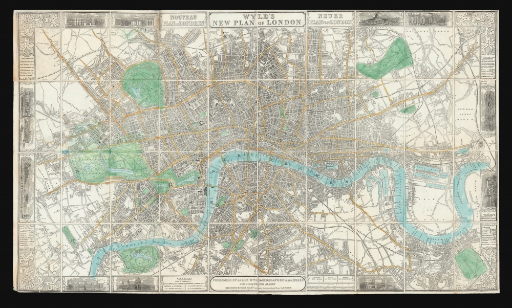
Wyld's New Plan of London.
1851 (undated) 22 x 37.25 in (55.88 x 94.615 cm) 1 : 17200
1851 (undated) 22 x 37.25 in (55.88 x 94.615 cm) 1 : 17200
Description
A decorative 1851 first edition plan or map of London, England by James Wyld. It was published to be of use to visitors to London's 1851 Great Exhibition of the Works of Industry of All Nations, also known as the Crystal Palace Exhibition.
This map is notable for its decorative border, with floral corner flourishes and illustrations of London landmarks, including, among others, Buckingham Palace, the British Museum, the Bank of England, London Bridge, and the Houses of Parliament.
A Closer Look
Centered on Blackfriars Bridge, the map covers central London from Islington to North Brixton and from the East India Docks to Holland Park. Roads, parks, rail lines, important buildings, and neighborhoods are noted. To the left and right of center, the English language title is repeated in French and German, respectively. Appropriately, the Crystal Palace appears prominently along the southern border of Hyde Park.This map is notable for its decorative border, with floral corner flourishes and illustrations of London landmarks, including, among others, Buckingham Palace, the British Museum, the Bank of England, London Bridge, and the Houses of Parliament.
Wyld's Globe
Among the border vignettes, in a place of prominence just to the right of the title, can be found a self-promotional view entitled, 'Mr. Wyld's Model of the Earth in Leicester Square.' This is Wyld's Great Globe, an attraction built in 1851, the year this map was issued, in Leicester Square, which was then a private pleasure garden. It consisted of a specially constructed dome containing a great sphere approximately 19 meters in diameter. On the interior walls of the sphere was a plaster of Paris scale model of the Earth. Scaffolding was erected at multiple levels so viewers could examine various locations in greater detail. The globe was a great success throughout its first year, but in subsequent years interest declined. It was ultimately deconstructed and sold for scrap in 1862. It was not until the 1935 construction of the Mapparium at the Mary Baker Eddy Library in Boston that a larger globe was constructed.The 1851 Crystal Palace Exhibition
The 1851 Crystal Palace Exhibition, officially titled the Great Exhibition of the Works of Industry of All Nations, was a landmark event held in London's Hyde Park. It was organized by Prince Albert (1819 - 1861) and Sir Henry Cole (1808 - 1882), who envisaged an international platform to showcase the innovations, arts, and technological prowess of the era. That venue, the Crystal Palace, was an architectural marvel in itself - an expansive iron and glass edifice designed by Sir Joseph Paxton (1803 - 1865), symbolizing the union of art, design, and engineering. Exhibitors flocked to this event, displaying a diverse array of products ranging from machinery to exotic artifacts, revealing the vast expanse of 19th-century human achievement. Drawing over 6,000,000 visitors, including dignitaries, intellectuals, and curious citizens, the exhibition was not merely a commercial or technological display; it was a cultural spectacle that emphasized Britain's central role in the Industrial Revolution. Moreover, the legacy of the Great Exhibition extended beyond its temporal confines, influencing design principles, shaping international trade and diplomacy, and inspiring subsequent world's fairs and expositions.Publication History and Census
The map was printed in 40 sections that were clearly designed to be dissected and mounted on linen, which apparently never occurred with this example. The present example is the first edition, first state. 15 additional editions followed with numerous updates and revisions to about 1877.Cartographer
Wyld (1823 - 1893) was a British publishing firm active throughout the 19th century. It was operated by James Wyld I (1790 - 1836) and his son James Wyld II (November 20, 1812 - 1887) were the principles of an English mapmaking dynasty active in London during much of the 19th century. The elder Wyld was a map publisher under William Faden (1749 - 1836) and did considerable work on the Ordinance Survey. On Faden's retirement in 1823, Wyld took over Faden's workshop, acquiring many of his plates. Wyld's work can often be distinguished from his son's maps through his imprint, which he signed as 'Successor to Faden'. Following in his father's footsteps, the younger Wyld joined the Royal Geographical Society in 1830 at the tender age of 18. When his father died in 1836, James Wyld II was prepared to fully take over and expand his father's considerable cartographic enterprise. Like his father and Faden, Wyld II held the title of official Geographer to the Crown, in this case, Queen Victoria. In 1852, he moved operations from William Faden's old office at Charing Cross East (1837 - 1852) to a new, larger space at 475 Strand. Wyld II also chose to remove Faden's name from all of his updated map plates. Wyld II continued to update and republish both his father's work and the work of William Faden well into the late 1880s. One of Wyld's most eccentric and notable achievements is his 1851 construction of a globe 19 meters (60 feet) in diameter in the heart of Leicester Square, London. In the 1840s, Wyld also embarked upon a political career, being elected to parliament in 1847 and again in 1857. He died in 1887 following a prolific and distinguished career. After Wyld II's death, the family business was briefly taken over by James John Cooper Wyld (1844 - 1907), his son, who ran it from 1887 to 1893 before selling the business to Edward Stanford. All three Wylds are notable for producing, in addition to their atlas maps, short-run maps expounding upon important historical events - illustrating history as it was happening - among them are maps related to the California Gold Rush, the New South Wales Gold Rush, the Scramble for Africa, the Oregon Question, and more. More by this mapmaker...
Condition
Good. Minor wear on original fold lines, especially at fold intersections. Some verso repair and reinforcement. Edge wear.
References
OCLC 83110220. Hyde, Ralph, Printed Maps of Victorian London, 1851 - 1900, #25.