This item has been sold, but you can get on the Waitlist to be notified if another example becomes available, or purchase a digital scan.
1832 S.D.U.K. Map of London and Environs, England
LondonEnvirons-SDUK-1832$125.00

Title
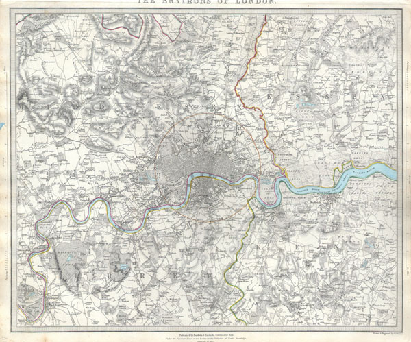
The Environs of London.
1832 (dated) 12.5 x 15.5 in (31.75 x 39.37 cm)
1832 (dated) 12.5 x 15.5 in (31.75 x 39.37 cm)
Description
A difficult to find map of the vicinity of London, England. Depicts the London area from Kingston and Hamton Court Park in the southwest to Stanmore in the northwest, Hennault Forest in the northeast and St. Marys Cray and Kevingtown in the southeast. A red circle around central London indicates the 'Extent of twopenny post delivery.' Crisp detail notes individual buildings, factories, kilns, butchers, farms, palaces, etc. Printed by Baldwin & Cradock of Paternoster Row, London, for the Society of for the Diffusion of Useful Knowledge on February 1st 1832.
Cartographer
The "Society for the Diffusion of Useful Knowledge" (1826 - 1848) was a Whiggish organization founded in 1828 at the instigation of idealistic British lord Henry Peter Brougham. The admirable goal of the Society was to distribute useful information via a series of publications to the English working and middle classes. It promoted self-education and the egalitarian sharing of all knowledge. While closely tied to the London University and publishing houses on the order of Baldwin and Cradock, Chapman and Hall, and Charles Knight, the Society failed to achieve its many lofty goals in finally closed its doors in 1848. Most likely the failure of the Society resulted from its publications being too expensive for its intended lower to middle class markets and yet not large and fine enough to appeal to the aristocratic market. Nonetheless, it did manage to publish several extraordinary atlases of impressive detail and sophistication. Their most prominent atlas consisted of some 200 separately issued maps initially published by Baldwin and Cradock and sold by subscription from 1829 to 1844. Afterwards, the Society combined the maps into a single world atlas published under the Chapman and Hall imprint. In its day, this atlas was unprecedented in its quality, scope, and cost effectiveness. Today Society, or S.D.U.K. as it is commonly known, maps are among the most impressive examples of mid-19th century English mass market cartographic publishing available. The S.D.U.K. is especially known for its beautiful and accurately detailed city plans. More by this mapmaker...
Source
Maps of the Society for the Diffusion of Useful Knowledge. Vol 1. 1844.
Condition
Very good condition. Part of title cropped from upper margin, as is common with this particular map. Minor discoloration to left margin, does not extend into printed area.
References
Rumsey 0890.185.