This item has been sold, but you can get on the Waitlist to be notified if another example becomes available, or purchase a digital scan.
1802 Wallis Pocket Plan or Map of London and Westminster, England
LondonWestminster-wallis-1802$475.00

Title
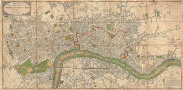
Wallis's Plan of the Cities of London and Westminster.
1802 (dated) 17 x 34.75 in (43.18 x 88.265 cm)
1802 (dated) 17 x 34.75 in (43.18 x 88.265 cm)
Description
An attractive example of John Wallis's 1802 map of London and Westminster. The map covers from Hyde Park eastward along the Thames River to White Horse Street and Stepney, and from Pentonville in the north to St. Georges Fields in the south. This finely engraved map offers impressive detail throughout identifying all streets and numerous important buildings, docks, parks, and bridges throughout. At this point in history only three bridges cross the Thames River: Westminster Bridge, Blackfriars Bridge, and London Bridge. The area destroyed and subsequently rebuilt following the 1666 Great Fire of London is highlighted in red. An inset in the lower left quadrant details Hackney-Coach Fairs as established by the London Commissioners in 1786. Wallis first published this map in 1795 as the 'New and Correct Plan of London and Westminster.' In 1797 he revised and updated it with the present name 'Wallis's Plan of the Cities of London and Westminster.' Under this title the map was issued in seven known editions, the present example being the 1802 5th edition. This edition includes only few updates over earlier editions, most notably a proposed development ghosted in to the west of Baker Street. The map, designed with daily usage in mind, has been dissected and mounted on linen in 20 sections for easy pocket storage, folding, and unfolding.
Cartographer
John Wallis (1745 - 1818) was a London map seller, publisher, and maker of puzzles and board games active in the late 18th and early 19th centuries. Wallis studied mapmaking under the stationer William Johnson, with home he was apprenticed from about 1769. Upon his release from apprenticeship he partnered with one "Stonehouse" to found the short-lived imprint "Wallis and Stonehouse". The firm lasted but two years before Wallis declared bankruptcy in 1778. Wallis subsequently started another independent firm specializing in children's books, games, and puzzles. In advertising ephemera issued c. 1812, Wallis claims, falsely, to have invented the puzzle map (this honor goes to either John Bowles (1759) or John Spilsbury (1767)). In 1813, he partnered with his son, Edward Wallis (c. 1787 - 1868), to found Wallis and Son, which proved, primarily under Edward's management, exceptionally successful. Wallis's cartographic corpus is significant, including many important Revolutionary War ears maps of the Americas, as well as various pocket and dissected maps of London, Westminster, and environs. Upon his death, Wallis passed his business on to his sons, Edward Wallis and John Wallis, who operated separate but successful firms. The Edward Wallis firm is considered the direct successor to John Wallis, and the John Wallis II firm a new and completely separate establishment. More by this mapmaker...
Condition
Good. Some discoloration and moderate overall toning. Dissected and mounted on linen in 20 panels. Original linen backing worn but stable with minor loss at fold intersections - see image.
References
Howgego, James L., Printed Maps of London circa 1553-1850, #214.5.