This item has been sold, but you can get on the Waitlist to be notified if another example becomes available, or purchase a digital scan.
1939 Sundberg Pictorial Map of the Pacific Ocean Blockade Against Japan
LongDistanceBlockade-sundberg-1939$250.00

Title
Long Distance Blockade.
1939 (dated) 15 x 22.75 in (38.1 x 57.785 cm) 1 : 42240000
1939 (dated) 15 x 22.75 in (38.1 x 57.785 cm) 1 : 42240000
Description
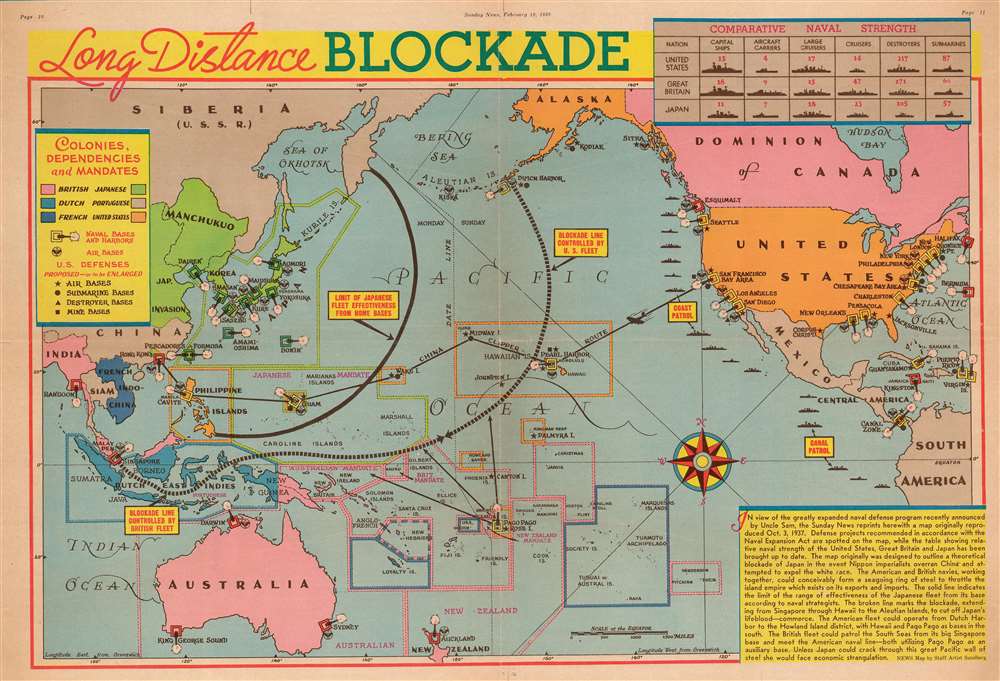
This is a 1939 Edwin Sundberg pictorial map of a hypothetical Pacific Ocean blockade against Japan. The map depicts the region from central Asia to the Atlantic Ocean and from the Bering Sea to New Zealand. Originally published in 1937 by the New York Sunday News in connection with the Second Sino-Japanese War, then raging in Asia between China and Japan, the News elected to update the content and publish a second edition after the announcement of the Naval Expansion Act.
The Map's Concept
The concept presented here is that the United States and Britain, working in concert, could create a naval blockade of Japan stretching from Singapore to the Aleutian Islands, represented here by the broken line, and cut off international trade to the island nation. Japan was dependent on imports, and the map's creators are putting forward the possibility that a naval blockade could cripple Japan without an all-out war. Per the map, by setting the blockade as suggested here, American and British navies would be outside the range of the Japanese fleet, although why this belief is put forward is unclear.Details, Details, Details
Various different colors and icons are used here, lending an air of confusion to this piece. It is, however, rather straight forward. Color is used to separate the dominions of the various international powers represented here. Pink highlights British territory, orange is American, blue denotes an area of Dutch supremacy, while green marks an area controlled by Japan. The relative proximity of green areas to pink and orange areas are important in hindsight, and probably even to those who viewed this map in 1939, because it was believed, and proved to be true, that the British and Americans would be the powers fighting Japan in the Pacific. The British hold territory from India to Canada, while the Americans possess the Philippines, Guam (which is located in the middle of a Japanese Mandate), Wake Island, and Hawaii. One of the first details that jumps off the page is the multi-colored squares with gun barrels poking out of them. These are the naval bases of the various belligerent powers, with British bases noted in red, American bases in yellow, and Japanese bases in green. Allied air bases are also noted, as is the American coast patrol, which is shown as operating from British Columbia to South America. The overall impression, which is reinforced by the chart of comparative naval strength in the upper-right corner, is that the Americans and British could easily best the Japanese.The Map's Date in Context
According to the date printed on the map, it was published on February 19, 1939, over six months before Hitler launches the Nazi invasion of Poland and begins World War II. This fact most likely intimates, along with the fact that this is an updated edition of a map originally published in 1937, that the publishers were not factoring in the necessity of fighting in Europe and the Pacific at the same time, as history tells us was the case.Publication History and Census
This map was created by Edwin Sundberg and published by the New York Sunday News on February 19, 1939. Even though Sundberg's works were produced for a New York City newspaper, his maps vary in scarcity today. The OCLC records only one example in an institutional collection at the National Library of Australia and we have not found any records of it entering the private market.Cartographer
Edwin L. Sundberg (1898 - 1978) was an American cartographer known for his pictorial pieces. Sundberg was a staff artist for the Sunday News in New York City and eventually became Chief Cartographer in charge of a small staff of artists. More by this mapmaker...
Condition
Very good. Newsprint. Closed margin tears professionally repaired on verso. Blank on verso.
References
OCLC 785820937.