This item has been sold, but you can get on the Waitlist to be notified if another example becomes available, or purchase a digital scan.
1824 Early American Promotional Map of Long Island
LongIsland-longislandcanalcompany-1824$937.50

Title
The Advertisement. Notice is hereby given, that Application will be made to the Legislature next Session, for an Act of Incorporation for the Long-Island Canal Company…
1824 (dated) 9.75 x 7.5 in (24.765 x 19.05 cm) 1 : 790000
1824 (dated) 9.75 x 7.5 in (24.765 x 19.05 cm) 1 : 790000
Description
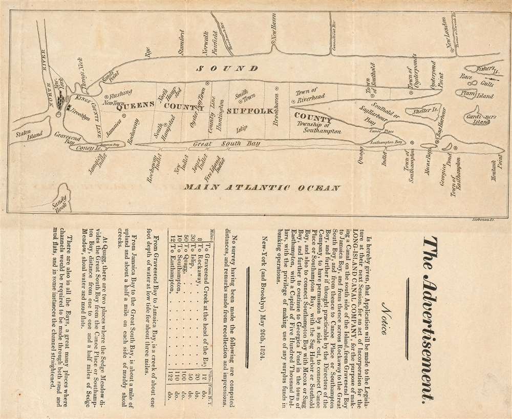
This is an 1824 map of Long Island, the earliest separate map we have identified of Long Island printed in the United States. The map was drawn with accompanying text to promote the construction of a new canal in southern Long Island - an effort that would presumable have significantly increased trade communication between southeastern Long Island and New York City, and from there, the world. It shows the cities of New York and Brooklyn pictorially; the Long Island towns of Flushing, Jamaica, Hampsted, Oyster Bay, Smithtown Brookhaven, Riverhead, Southold, Oysterponds, Southhampton, and Easthampton are marked on the map. In Connecticut, Rye, Stamford, Norwalk, Fairfield, New Haven and New London are named. The map is schematic in the extreme, with its best detail shown along the southern shore of the island - detailing the inlets along the barrier islands from Coney Island, Rockaway and Fire Island, and the waterways just inland.
The Text
The map is appended to a formal announcement of the application to the New York State Legislature for the incorporation of the Long Island Canal Company,for the purpose of making a Canal on the south side of the Island, from Gravesend Bay to Jamaica Bay, and from hence across Rockaway to the Great South Bay, and from thence to Canoe Place or Southampton Bay, and further if thought practicable by the Directors of the Company, to have permission by a side cut, to connect Canoe Place or Southampton Bay, with there Sag Harbor or Southold Bay, and also to connect Southampton Bay with Mecox or Sagg Bay, and further to continue to Georgica Pond in the town of Easthampton…The text goes on to enumerate relevant distances, and describe the coastal conditions of the relevant areas. While there is documentary evidence that the company was indeed incorporated in 1828, there is no similar evidence that any of the company’s aims were ever achieved, or indeed even embarked upon. A significantly more modest canal connecting the Great Peconic Bay with Shinnecock Bay (Southhold Bay and Southampton Bay on the map, respectively) was eventually constructed in 1892.
The Engraver
We should like to praise the creator of so early an American publication, but the historical record is remarkably opaque with regard to the Liebenau whose imprint appears on the map. The 1827 and 1829 editions Thomas Longworth’s American Almanac identifies an engraver Frederick Liebenau at 42 Vesey Street in New York, which is very likely our man, but no other work appears to be credited to him.Publication History and Census
There are no examples of this 1824 map in OCLC, and this is the only example we have seen on the market or catalogue records. The map was also included in an 1826 pamphlet prepared for the Legislature, which is also rare: it appears in only four institutions in OCLC.Cartographer
Frederick Liebenau (fl. 1827-9) was an engraver in New York in the first part of the 19th century. It is possible that this is actually Heinrich Frederick Liebenau, born in Germany in 1770 but married at Trinity Church in New York in 1800, dying in New York in 1826, but we have only the loosest circumstantial evidence to draw this conclusion. More by this mapmaker...
Condition
Good condition. Some wear at edges and corners.