This item has been sold, but you can get on the Waitlist to be notified if another example becomes available, or purchase a digital scan.
1873 Beers Wall Map of Long Island, New York
LongIsland2-beers-1873$1,000.00

Title
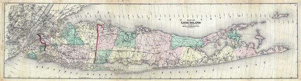
Map of Long Island.
1873 (undated) 14 x 52 in (35.56 x 132.08 cm)
1873 (undated) 14 x 52 in (35.56 x 132.08 cm)
Description
A first edition, first issue, of one of the largest and most impressive maps of Long Island, New York to appear in the 19th century. Published in 1873, this magnificent map covers the whole of Long Island as well as parts of Manhattan, Staten Island, and Hudson County, New Jersey. Offers incredible detail with regard to districts, railroads, cities, and roadways. Longitude is given both in degrees west of the Greenwich meridian and in degrees east of Washington, D.C. Also indicates miles in radial distances from New York's City hall. Prepared by Beers, Comstock & Cline out of their office at 36 Vesey Street, New York City, for inclusion in the first published atlas of Long Island, the 1873 issue of Atlas of Long Island, New York.
Cartographer
The Beers family (Fredrick, Silas, James and Daniel) (fl. c. 1850 - 1886), along with Charles and Augustus Warner, were prominent map publishers working from the 1850s to the late 1880s. Often publishing under the Warner & Beers designation, the combined firms produced a series of important state and county atlases and map of much of the northeastern United States. Many of their regional maps are among the most detailed and well laid out maps ever produced of their respective regions. Because Warner & Beers county maps were often detailed down to the individual homes and landowners, they have become highly sought after by general and family historians. In additional to producing maps of surpassing detail, Warner & Beers also maintained an earlier generation's attention to detail and quality while publishing in an era ever increasingly dominated by the low cost printing methods used by the publishing empires of Rand McNally and George Cram. More by this mapmaker...
Source
Atlas of Long Island, New York. From Recent Actual Surveys and Records Under the Superintendence of F. W. Beers. (1873 First Edition)
Condition
Good. Some wear along original fold lines. Professionally flattened and backed with archival tissue.
References
Allen, David Yehling, Long Island Maps and Their Makers, p 94-97. Haskell, Daniel C., Manhattan Maps: A Co-operative List, 1263.