1788 Bowen / D'Anville Map of the Gulf Coast and Mississippi River Delta
Louisiana-bowen-1788$950.00
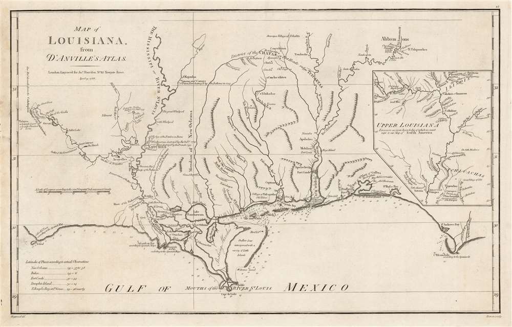

Title
Map of Louisiana, From D'Anville's Atlas.
1788 (dated) 12 x 19.5 in (30.48 x 49.53 cm) 1 : 1700000
1788 (dated) 12 x 19.5 in (30.48 x 49.53 cm) 1 : 1700000
Description
This is a handsome example of the scarce 1788 English edition of Jean Baptiste Bourguignon d'Anville's map of the Gulf Coast and Lower Mississippi River Valley, engraved by Thomas Bowen for John Harrison. This is the best obtainable map of the Lower Mississippi at the time of publication - here in a rare English edition.
A Closer Look
The map covers from Sabine Pass (Cabo del Norte), Texas, past the Mississippi River Delta, Mobile Bay, and Pensacola Bay, to the Apalachicola River in Florida. Coverage extends northwards along the Mississippi River as far as, roughly, Lake Providence and northwards along the Alabama River (Riviere des Alibamons) as far as Fort Toulouse (modern-day Wetumpka, Alabama). An inset in the upper right traces the upper Mississippi River Valley and includes much of the lower Missouri River as far as the Kansas River (Kansaz). Mountains are illustrated pictorially, but the region's river courses, including the Lower Mississippi, the Red, the Osage, and the Lower Missouri, are depicted in detail. Depth soundings are noted along the Gulf Coast and in the adjacent bays.Valentin Devin
Cartographically, much of the coastal information presented here is derived from manuscript work compiled by French Royal Engineer Valentin Devin between 1720 and 1732. Devin's work was incorporated into this map, as well as into others by competing French cartographers Philippe Buache, Nicholas Bellin, and Guillaume De L'Isle. Another Royal Engineer, Ignace François Broutin, is responsible for much of the inland cartography, particularly around Natchitoches and Natchez.Historical Context
D'Anville drew this map following the 1730 French siege and subsequent destruction of the Grand Village of Natchez. The attack was a retaliatory move on the part of the French following the 1728 Natchez Massacre, in which 229 French colonists in nearby Fort Rosalie (depicted) were slain. The war ultimately dispersed the once powerful Natchez Nation. Many of the Natchez diaspora were subsequently absorbed into the Creek and Chickasaw. The Grand Village of Natchez itself re-emerged as a European trading center on the Mississippi.A Detailed Mississippi Valley
D'Anville's map is most richly detailed along the Mississippi River, especially the Lower Mississippi in the vicinity of New Orleans, on which the map is loosely centered. Numerous towns and villages, both European and American Indian, are identified throughout, alongside fortifications both actively occupied and abandoned. Some depth soundings appear in Lake Pontchartrain. The Chandeleur Sound is noted as having many little-known islands. The mouth of the Mississippi, with its complex network of channels, is, for the period, well mapped.The French-Mexican Frontier
The map extends westward along the Red River (Riviere Rouge) as far as Tecas (Texas), the limit of French dominion. Here the French Fort of Natchitoches stands but seven leagues from the Spanish Presidio de San Miguel Arcangel de Linares de Adayes, noted as Adayes, a Spanish garrison of the Province of Tecas.The French-English Frontier
At the opposite extreme of the map is Fort Toulouse at the conjunction of the Coosa and Tallapoosa Rivers, in the country of the Alibamons (from which the state name Alabama is derived). The French established Fort Toulouse in 1717 as a bastion against English incursion into French territory. Records suggest that the Alabama Indians invited the French, who they perceived as the lesser of two evils, during the Yamasee War (1715 - 1717). The Yamasee War was fought between English settlers in South Carolina and various American Indian Nations. The French abandoned Fort Toulouse in 1763.The Inset
The inset map in the upper right, though small, is significant because it offers an interesting perspective on the Upper Mississippi and Lower Missouri Rivers. Here D'Anville has confused the Ohio and Wabash Rivers, presenting them as a single river - an error that D'Anville corrects in his later map Amerique SeptentrionalePublication History
This map was engraved by Thomas Bowen in 1788 for inclusion in John Harrison's D'Anville's Atlas Containing a Map of the World. We see 13 examples of the separate map cataloged in OCLC. The complete atlas is listed in only two collections, Harvard and the Bayerische Staatsbibliothek.CartographerS
Thomas Bowen (b. c. 1733 - March 1790) was a Welsh engraver of maps and charts. He was the son of Emanuel Bowen (1693/4–1767), under whom he had apprenticed. His work was printed with his father's, as well as other publishers throughout the latter half of the eighteenth century. He married Alice Downes on December 25, 1768. He appears even thento have not been successful, and more than once found himself a debtor. He was imprisoned for debt in 1761, and he met his death in 1790 in Clerkenwell workhouse. More by this mapmaker...
Jean Baptiste Bourguignon d'Anville (1697 - 1782) was perhaps the most important and prolific cartographer of the 18th century. D'Anville's passion for cartography manifested during his school years when he amused himself by composing maps for Latin texts. There is a preserved manuscript dating to 1712, Graecia Vetus, which may be his earliest surviving map - he was only 15 when he drew it. He would retain an interest in the cartography of antiquity throughout his long career and published numerous atlases to focusing on the ancient world. At twenty-two D'Anville, sponsored by the Duke of Orleans, was appointed Geographer to the King of France. As both a cartographer and a geographer, he instituted a reform in the general practice of cartography. Unlike most period cartographers, D'Anville did not rely exclusively on earlier maps to inform his work, rather he based his maps on intense study and research. His maps were thus the most accurate and comprehensive of his period - truly the first modern maps. Thomas Basset and Philip Porter write: "It was because of D'Anville's resolve to depict only those features which could be proven to be true that his maps are often said to represent a scientific reformation in cartography." (The Journal of African History, Vol. 32, No. 3 (1991), pp. 367-413). In 1754, when D'Anville turned 57 and had reached the height of his career, he was elected to the Academie des Inscriptions. Later, at 76, following the death of Philippe Buache, D'Anville was appointed to both of the coveted positions Buache held: Premier Geographe du Roi, and Adjoint-Geographer of the Academie des Sciences. During his long career D'Anville published some 211 maps as well as 78 treatises on geography. D'Anville's vast reference library, consisting of over 9000 volumes, was acquired by the French government in 1779 and became the basis of the Depot Geographique - though D'Anville retained physical possession his death in 1782. Remarkably almost all of D'Anville's maps were produced by his own hand. His published maps, most of which were engraved by Guillaume de la Haye, are known to be near exact reproductions of D'Anville' manuscripts. The borders as well as the decorative cartouche work present on many of his maps were produced by his brother Hubert-Francois Bourguignon Gravelot. The work of D'Anville thus marked a transitional point in the history of cartography and opened the way to the maps of English cartographers Cary, Thomson and Pinkerton in the early 19th century. Learn More...
Source
Harrison, John, D'Anville's atlas containing a map of the world, (London) 1792.
Condition
Very good. Marginal mends, not impacting printed image. Else excellent.
References
OCLC 5414405. Sellers, John R. and Van Ee, Patricia, Maps and Charts of North America, #1616.