1948 Wendt Andry Pictorial Tourist Map of Louisiana
Louisiana-wendtandry-1948$850.00

Title
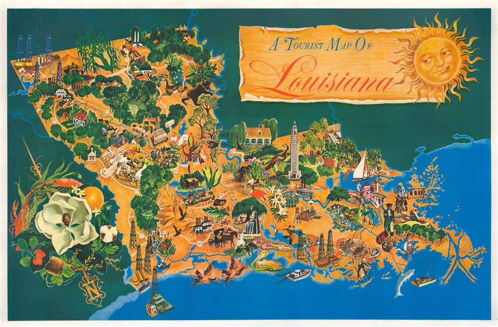
A Tourist Map of Louisiana.
1948 (undated) 21 x 32.75 in (53.34 x 83.185 cm)
1948 (undated) 21 x 32.75 in (53.34 x 83.185 cm)
Description
This is a fantastic c. 1948 Margaret Wendt Andry pictorial tourist map of Louisiana. Wonderful illustrations present aspects of life in Louisiana, including the oil industry, its wide agricultural base that includes growing cotton and oranges, and recreational opportunities, including hunting and fishing. Prawns appear in several places, alongside a crab and an oyster. Waterfowl, including pelicans, egrets, and ducks, appear as well. The Louisiana State Capitol building in Baton Rouge is prominently illustrated. A large magnolia (the Louisiana state flower) decorates the compass that occupies the lower left corner and an orange, a prawn, and some cotton help make up this charming illustration.
Publication History and Census
This map was drawn by Margaret Wendt Andry and published c. 1948. We note only one example cataloged in OCLC which is part of the collection at Louisiana State University.Cartographer
Margaret Wendt Andry (September 29, 1920 - March 13, 1996) was an American graphic designer. A lifelong resident of New Orleans, Andry graduated from Eleanor Mcmain High School and Newcomb College, she also attended graduate school at Newcomb. During World War II, she worked as a graphic designer for the U.S. Navy in Washington D.C. and after returning to New Orleans worked as a graphic designer for several companies there. She worked as a reference library in the New Orleans Public Library for thirty-five years and retired in 1995. She had three daughters and one stepdaughter. More by this mapmaker...
Condition
Very good. Mounted on heavy linen.
References
OCLC 818331369.