
1902 Rand McNally Map of Louisiana issued for Immigration

This item has been sold.
Louisiana.
- Digital Map Information
- Suitable for large format printing
- Full resolution TIFF file
- ICC color profile embedded
- Delivered instantly via download link
A Closer Look
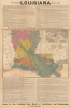
Coverage embraces the state of Louisiana and adjacent parts of Mississippi and Texas. The map is color-coded to illustrate land types: alluvial, marsh, pine hills, prairies, bluffs, uplands, etc. Extensive text above and below the map glowingly describes Louisiana's potential.Rebuilding Post-Reconstruction
Headed by commissioner John Gilore Lee and starting around 1902, Louisiana launched an ambitious state-sponsored immigration campaign to revive its post-Reconstruction economy, address chronic labor shortages, and attract smallholding European farmers. Through the Louisiana Board of Agriculture and Immigration, officials distributed multilingual pamphlets and dispatched agents to Europe promoting the state's fertile soil, mild climate, and cheap land. The Board targeted settlers from Italy, Germany, Hungary, and Scandinavia, hoping to diversify the population and reduce reliance on Black labor within the Jim Crow order.To accomplish this, Louisiana privatized its public lands to stimulate development, expand agriculture, and attract both domestic and foreign settlers. These lands, much of it swamp, forest, and cutover terrain in the southern and western parishes, were part of vast federal and state holdings dating to earlier Spanish, French, and U.S. cessions. Following the 1898 state constitution, Louisiana's legislature authorized the State Land Office and Board of Immigration to advertise and dispose of these tracts - often at low prices ($1-2 per acre) or through homestead-style purchase plans.
Railroad companies, timber firms, and speculators acquired enormous areas, particularly in the pine-rich hill country of north and central Louisiana and the swamplands of the Atchafalaya Basin. The longleaf pine forests attracted northern lumber corporations such as Great Southern Lumber Company and Long-Bell Lumber Company, leading to a boom in sawmills and new 'company towns' (Bogalusa, DeRidder, Alexandria). Meanwhile, the state marketed cutover and drained lands in the southwest prairies to small farmers - many of them Italian, German, and Midwestern migrants - for rice, sugar, and cattle farming. The Louisiana Bureau of Agriculture and Immigration published pamphlets praising the state as a place where 'every man of industry may own his land.'
By the 1910s, most state-held lands had been sold or leased, marking the transformation of Louisiana from a frontier of public domain to a mosaic of private, corporate, and smallholder ownership. Yet, this land rush also resulted in massive deforestation, environmental degradation, and the concentration of wealth in the hands of lumber barons and large planters. These developments later fuel calls for conservation reform and state regulation during the Progressive Era.
Publication History and Census
This map was designed by John Gilmore Lee, head of the Louisiana Board of Agriculture and Immigration, in 1902. Maps with the same or similar titles issued from 1901 - 1908. In as many as six editions, OCLC catalogs holdings in 12 libraries, although we do not see another example of this 1902 issue.Cartographer
Rand, McNally and Co. (fl. 1856 - present) is an American publisher of maps, atlases and globes. The company was founded in 1856 when William H. Rand, a native of Quincy, Massachusetts, opened a print shop in Chicago. Rand hired the recent Irish immigrant Andrew McNally to assist in the shop giving him a wage of 9 USD per week. The duo landed several important contracts, including the Tribune's (later renamed the Chicago Tribune) printing operation. In 1872, Rand McNally produced its first map, a railroad guide, using a new cost effective printing technique known as wax process engraving. As Chicago developed as a railway hub, the Rand firm, now incorporated as Rand McNally, began producing a wide array of railroad maps and guides. Over time, the firm expanded into atlases, globes, educational material, and general literature. By embracing the wax engraving process, Rand McNally was able to dominate the map and atlas market, pushing more traditional American lithographic publishers like Colton, Johnson, and Mitchell out of business. Eventually Rand McNally opened an annex office in New York City headed by Caleb S. Hammond, whose name is today synonymous with maps and atlases, and who later started his own map company, C. S. Hammond & Co. Both firms remain in business. Further Details...
Condition
Very good. Minor verso repair and stabilization at fold intersections and where originally attached to binder.