1844 Black Map of Egypt, Asia Minor and the Sinai Peninsula
LowerEgyptStPaul-black-1844$100.00
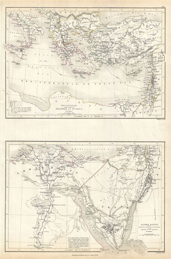

Title
The Countries embraced within the Travels of St. Paul. Lower Egypt with the Peninsula of Mt. Sinai and the Journeys of the Israelites.
1844 (undated) 17 x 11.5 in (43.18 x 29.21 cm) 1 : 8400000
1844 (undated) 17 x 11.5 in (43.18 x 29.21 cm) 1 : 8400000
Description
This is a fine example of Adam and Charles Black's 1844 Biblical reference map of Greece, Italy, Asia Minor and Lower Egypt in antiquity. The map is divided into two parts: The upper map covers the countries traveled by St. Paul, which include Italy, Greece and the Balkans and Asia Minor south as far as Arabia and Egypt. The lower map depicts the Sinai Peninsula and Egypt and follows the journeys of the Israelites. It covers Egypt, centered on the Nile River, and extending south as far as Hermopolis. Both maps feature ancient and contemporary place names, i.e.. Candia and Crete, for each destination - an invaluable resource or scholars of antiquity. Throughout, the map identifies various cities, towns, rivers, mountain passes and an assortment of additional topographical details with relief shown by hachure.
The journeys of St. Paul are depicted on the upper map by variously dotted lines to differentiate from the first to the fifth journey. The lower map also depicts the Journeys of the Israelites from their first arrival at Kadesh and their second and third arrival and departure thereof. It shows the course of the Israelites as they fled out of Egypt, across the Red Sea, and subsequently spent the next forty years wandering in the Sinai before migrating into the Promised Land by crossing the Jordan River just north of the Dead Sea. This map was engraved by Sidney Hall for issue as plate no. LX in the 1844 edition of Black's General Atlas.
The journeys of St. Paul are depicted on the upper map by variously dotted lines to differentiate from the first to the fifth journey. The lower map also depicts the Journeys of the Israelites from their first arrival at Kadesh and their second and third arrival and departure thereof. It shows the course of the Israelites as they fled out of Egypt, across the Red Sea, and subsequently spent the next forty years wandering in the Sinai before migrating into the Promised Land by crossing the Jordan River just north of the Dead Sea. This map was engraved by Sidney Hall for issue as plate no. LX in the 1844 edition of Black's General Atlas.
CartographerS
Charles and Adam Black (fl. 1807 - present) were map and book publishers based in Edinburgh. Charles and his uncle, Adam, both of Edinburgh, Scotland, founded their publishing firm in 1807. They published a series of maps and atlases throughout the 19th century. In addition to an array of atlases, the Black firm is known for their editions of the Encyclopedia Britannica (1817 - 1826) and the first publishing of Sir Walter Scott's novels in 1854. In 1889 the A. & C. Black publishing house moved to London where it remains in operation to this day. More by this mapmaker...
William Hughes (c. 1818 - May 21, 1876) was a cartographer, engraver, lithographer, printer, and publisher active in London during the middle part of the 19th century. Hughes enjoyed and long and varied cartographic career. He was elected a Fellow of the Royal Geographical Society in 1838 and, from about 1840, taught geography and mapmaking at St. Johns College for Civil Engineers. He later taught the same at both Queens College and Kings College, London. For a time he was employed as a map librarian for the British Museum. Hughes began engraving maps around 1839 and worked with most of the prominent British map and atlas publishers of his era, including but not limited to Charles Knight, A. and C. Black, George Philip, William Cassell, and others. Learn More...
Source
Black, A. and C., Black's General Atlas (Edinburgh), 1844.
Black's General Atlas was a popular Scottish atlas of the world issued by the Edinburgh firm of Adam and Charles Black. This atlas was first issued in 1840 with subsequent editions being printed well into the 1890s. While most editions were printed in Edinburgh, an American edition was issued in 1857. Most early editions of his atlas were engraved by S. Hall. Typically this refers to Sidney Hall, who died in 1831, but in this case, since the engraving was initiated well after his death, it was most likely his widow, Selina Hall, who did the engraving. Later editions feature additional maps updated and engraved by William Hughes. Early editions featured outline color only, but later editions embraced a full color approach with pale green, yellow, and blue pastels. All editions are known for their meticulous presentation of the most up-to-date cartographic information. Moreover, this exceptionally long publication run provides a fine cartographic record of the middle to late 19th century - particularly as regards the complex cartographic evolution of the Americas through this period.
Condition
Very good. Original platemark visible. Blank on verso.
References
Rumsey 2305.072 (1854 edition). Philips (atlases) 4334.