This item has been sold, but you can get on the Waitlist to be notified if another example becomes available, or purchase a digital scan.
1940 Chapin Pictorial Map of Belgium and the Netherlands Invaded by Nazis
LowlandsAttacked-chapin-1940$175.00

Title
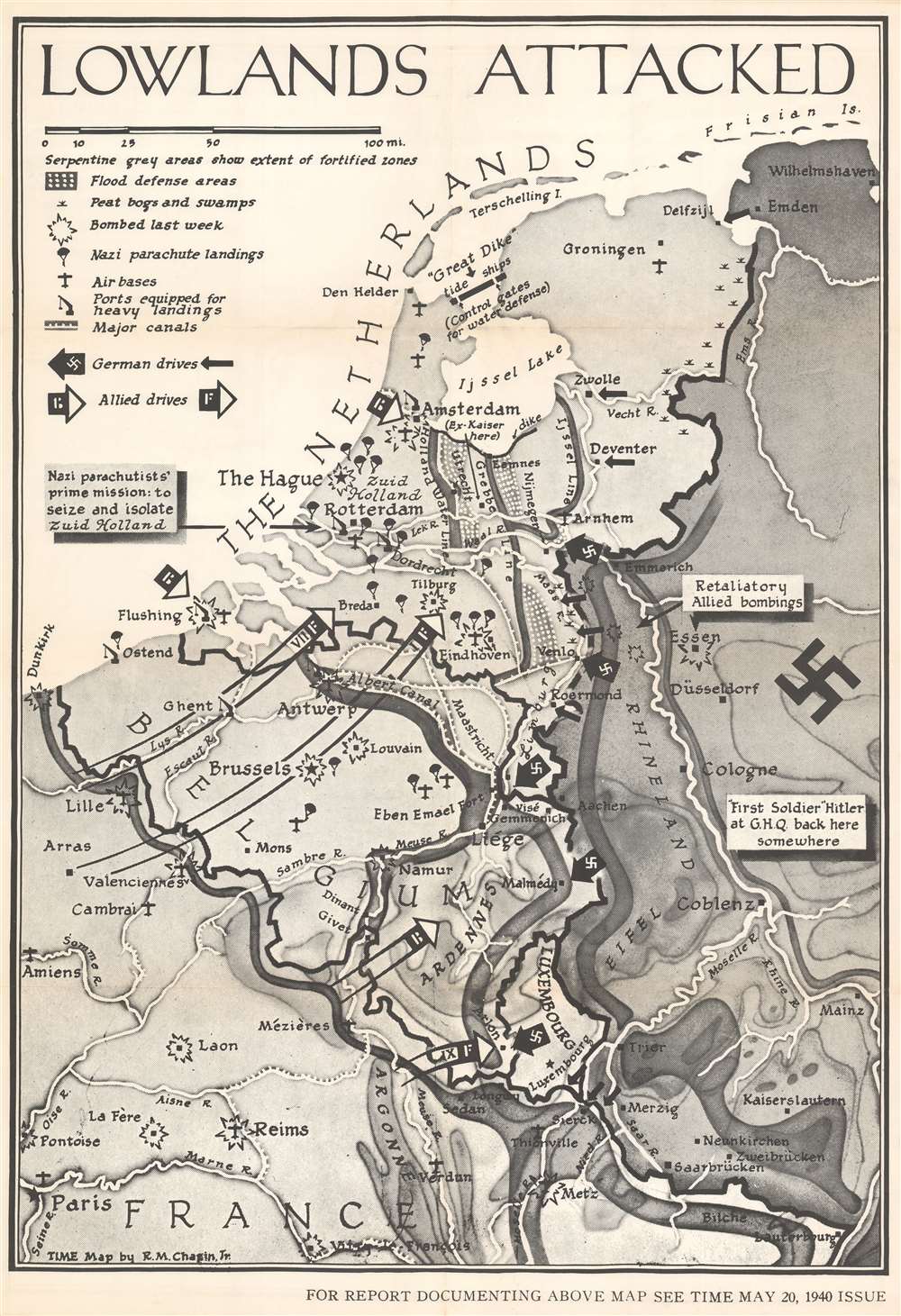
Lowlands Attacked.
1940 (dated) 39.75 x 27.5 in (100.965 x 69.85 cm) 1 : 633600
1940 (dated) 39.75 x 27.5 in (100.965 x 69.85 cm) 1 : 633600
Description
This is a large-format separate issue 1940 Robert M. Chapin Jr. pictorial map of Belgium and the Netherlands during the German invasion of Western Europe. Published only ten days after the Nazis launched their assault, the map depicts the region from Dunkirk to Wilhemshaven and from the North Sea to Paris. Thick black arrows marked with swastikas identify the German drive west, while white tipped arrows highlight the British and French response. Explosions mark cities and airfields bombed the week before, and icons of paratroopers present where German parachute landings took place.
The 1940 Nazi Invasion of Western Europe
The blitzkrieg launched against Belgium, the Netherlands, and France took the Allies by surprise. Launched on May 10, 1940, the German army stormed through the Ardennes, a region known for its dense forests and rolling hills. The Allies had expected a frontal assault and built the vaunted Maginot Line over the previous decade to counter such a move. The Germans simply went around. Not six weeks later, the French army had been defeated in a series of decisive battles and the British Expeditionary Force, along with some French and Belgian soldiers, had been evacuated from Dunkirk. An unopposed German army occupied Paris on June 14, and on June 18 the French government sued for peace. An armistice between the two countries was signed on June 22, 1940 that established a northern Occupied Zone the covered two-thirds of France and a southern Unoccupied Zone governed by Marshal Petain from Vichy (known to history as Vichy France). The southern zone was occupied by the Nazis in November 1942 after the Allied landings in North Africa and the process of liberating western Europe did not begin until June 6, 1944 with the Allied landings in Normandy.Publication History and Census
This map was created by Robert M. Chapin, Jr. for publication in the May 20, 1940 issue of TIME. This is the only known surviving example.Cartographer
Robert M. Chapin Jr. (fl. 1933 - 1970) was a prominent architect, cartographer and illustrator active during World War II and the Cold War. Chapin graduated from the University of Pennsylvania in 1933 with a degree in architecture. Since this was the height of the Great Depression, and architects in low demand, he instead took work as a staff cartographer at Newsweek. Catching the attention of Manfred Gottfried of Time, Chapin was offered an accepted a position at the head of Time's cartography department. He remained with Time for some 33 years, from 1937 to 1970, often drawn 2 - 3 new thematic maps weekly. With an architect's gift visualizing information, Chapin became a skilled informational cartographer, heading the cartography department at Time Magazine. Chapin, like Fortune Magazine chief cartographer, Richard Edes Harrison, Chapin was at the forefront of infographic propaganda cartography, a genre that matured during the World War II Era and remains popular today. Working for Time Magazine, Chapin developed a signature style for his long run of 'War Maps.' Chapin was known for his maverick airbrush technique which lead to strong color splashes and intense shading. He also incorporated celluloid stencils to illustrate bomb explosions, flags, sinking ships, and more - generating a instantly recognizable standardized style. Chapin's Time war maps were further distinctive for their use of strong bold reds as a universal symbol of hostility. Chapin graduated from the University of Pennsylvania in 1933 with a degree in architecture. Since this was the height of the Great Depression, an d architects in low demand, he instead took work as a staff cartographer at Newsweek. Catching the attention of Manfred Gottfried of Time, Chapin was offered an accepted a position at the head of Time's cartography department. He remained with Time for some 33 years, from 1937 to 1970, often drawn 2 - 3 new thematic maps weekly. Chapin live in Sharon Connecticut. More by this mapmaker...
Condition
Very good. Light wear along original fold lines. Blank on verso.