
This item below is out of stock, but another example (left) is available. To view the available item, click "Details."
Details
1945 Bennett Pictorial Map of Luzon, Philippines
$950.00
1945 Bennett Pictorial Map of Luzon, Philippines
LuzonImpressions-bennett-1945$475.00

Title
I Corps in the Philippines: Luzon Impressions.
1945 (dated) 17 x 21 in (43.18 x 53.34 cm)
1945 (dated) 17 x 21 in (43.18 x 53.34 cm)
Description
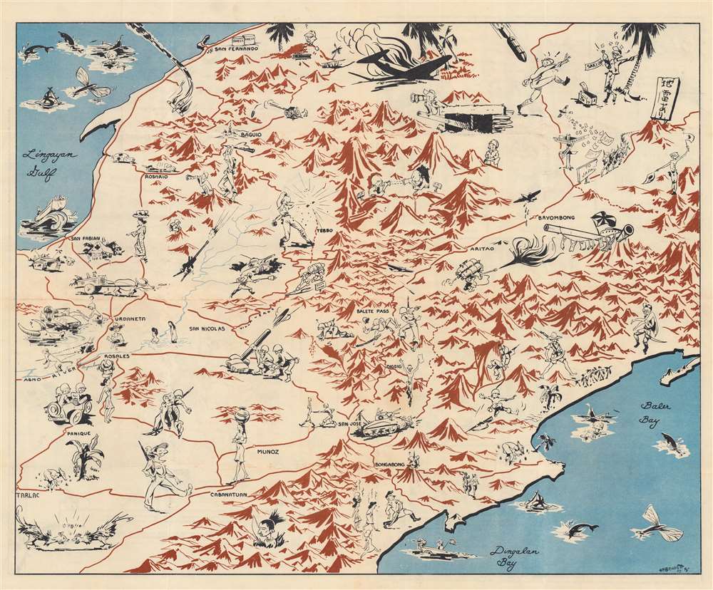
This is a 1945 Information and Education Section pictorial map of central Luzon, the Philippines, drawn by H. R. Bennett.
A Closer Look
Depicting central Luzon from Lingayen Gulf to Baler Bay and Dingalan Bay, caricatures of American soldiers, Japanese soldiers, and native Filipinos populate the map. Per text on the map's verso,This cartoon pictorial, 'Luzon Impressions' portrays typical scenes witnessed on Luzon in the I Corps zone of action. Each caricature has a story behind it. You may have been a part of one of these scenes.Unfortunately none of these scenes are described in detail. Some appear to be rather self-explanatory, others are more obscure. Nonetheless, the piece offers insights into military life on Luzon in June of 1945.
Verso Content
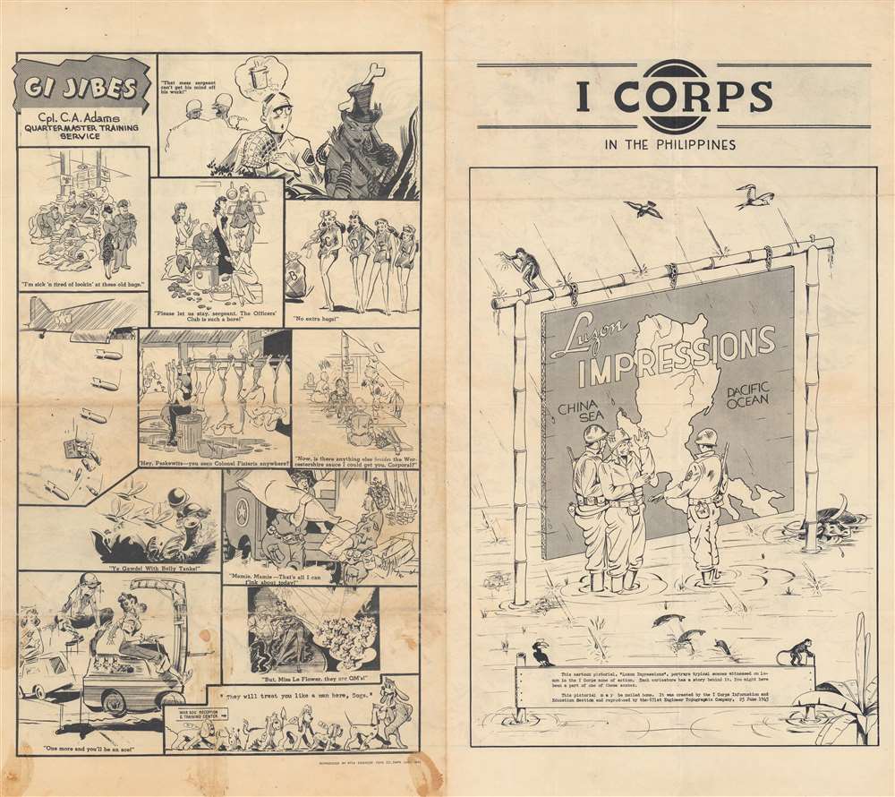
Three soldiers appear in front of a large map of Luzon (crafted out of wood?) on the right panel on the verso. It's hanging from chains on a bamboo frame and the soldiers are standing in ankle-deep water in pouring rain. A dozen cartoons occupy the left side of the verso and comically reference Army life.The Philippine Campaign
Launched on October 20 of 1944, the Philippine Campaign was a World War II joint American and Filipino military operation intended to liberate the Philippine Islands from occupying Imperial Japanese forces. The Japanese Army overran most of the Philippines during the first half of 1942, retaining it for the subsequent 2 years. American General Douglas MacArthur began the campaign by announcing on Philippine radio 'This is the Voice of Freedom, General MacArthur speaking. People of the Philippines: I have returned.' The campaign progressed rapidly, driving the Japanese out of one island after another. Although by this time the Japanese were clearly losing the war, they gave no sign of capitulation and refused to surrender. During the course of the campaign Japan suffered nearly half a million casualties compared to only about 50,000 Americans. The campaign continued until Japanese forces in the Philippines were ordered to surrender by Tokyo on August 15, 1945, after the dropping of atomic bombs on Hiroshima and Nagasaki.Army Information and Education Division
In October 1943, amid a flurry of reorganization and debate concerning education in America, the U.S. Army decided to expand and consolidate its programs to educate its soldiers. General George Marshall, the Army Chief of Staff, took an interest in this project, and decreed that the Special Services Division (which became the Information and Education (IE) Division in February 1944) would be divided into four branches: Orientation, Information, Education, and Research. According to the article 'The Most Wonderful Thing Has Happened to Me in the Army: Psychology, Citizenship, and American Higher Education in World War II'those branches directed the army's worldwide radio network, published its collection of soldier newspapers and magazines, and coordinated its growing number of educational programs - everything from recruit orientation and college-level correspondence study during the war to the organization of army university centers after it.Larger units in both the European and Pacific theaters had Information and Education Sections and smaller units had Information and Education Officers. According to the Combat History of the 137th Infantry Regiment, their Information and Education Section conducted Regimental-sponsored tours of 'points of both scenic and historic interest along the Rhine River'.
Engineer Topographic Battalions during World War II
After World War II erupted in Europe, U.S. military officials realized that currently available maps of Europe were inadequate for modern artillery units or even tactical purposes. Their solution was the creation of engineer topographic battalions. Engineer Topographic Battalions provided technical support for the U.S. Army in the form of surveying, drafting, and printing maps for units on the ground. During the war, these battalions were responsible for surveying, creating, printing, and distributing accurate four-color topographic maps.Publication History and Census
This map was drawn by H. R. Bennett in the Philippines for the I Corps Information and Education Section and printed by the 671st Engineer Topographic Company and is dated June 25, 1945, about a month and a half before World War II in the Pacific ended. We note only two cataloged examples in OCLC which are part of the collections at the Wisconsin Veterans Museum Research Center and Stanford University.Condition
Very good. Light wear along original fold lines. Light soiling only evident on verso.
References
OCLC 60679179.