This item has been sold, but you can get on the Waitlist to be notified if another example becomes available, or purchase a digital scan.
1740 Gregoire Wall Map of Lyon, France (19th century restrike)
LyonFrance-gregoire-1740$500.00

Title
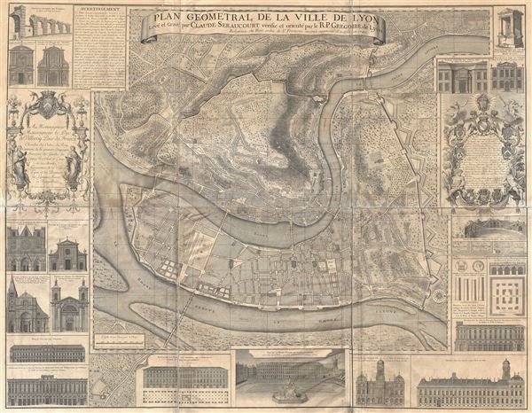
Plan Geometral de la Ville de Lyon.
1740 (19th century restrike) 55 x 44 in (139.7 x 111.76 cm) 2.819444444
1740 (19th century restrike) 55 x 44 in (139.7 x 111.76 cm) 2.819444444
Description
A gigantic wall map of Lyon, France by R. P Gregorie and Claude Seraucourt. Originally issued in 1735, the present example reflects a c. 1880 restrike of the 1740 revised edition. Oriented to the east, this map centers on the convergence of the Rhone and Saone Rivers and the presqu'Ile, or peninsula, thus formed. It covers modern day Lyon's 1st and 2nd arrondissements as well as significant portions of the 4th and 5th. The map is surrounded by illustrations depicting Lyon's most noteworthy architecture and monuments, as well as two rococo windows with dedications to the Duc de Villeroy and various others. We are not certain when this restricke was printed, but it was certainly done from the original plate and based upon the thick woven paper, must have been issued between about 1850 and 1900. The map is presented in six sections which have been bonded to linen hinges for folding and unfolding. We are fairly confident, however, that it did not come from the chalcographie office at the Louvre - as it lacks the usual imprint.
Condition
Good. Overall toning and light soiling.. Some tears along the edges repaired. Six panels hinged with linen. Blank verso.