This item has been sold, but you can get on the Waitlist to be notified if another example becomes available, or purchase a digital scan.
1740 Gregoire Wall Map of Lyon, France
LyonFrance3-gregoire-1740$3,250.00

Title
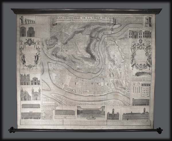
Plan Géometral de la Ville de Lyon.
1740 (dated) 49 x 57 in (124.46 x 144.78 cm) 1 : 4000
1740 (dated) 49 x 57 in (124.46 x 144.78 cm) 1 : 4000
Description
A large wall map of Lyon, France by R. P Grégorie and Claude Seraucourt. Oriented to the east, this map centers on the convergence of the Rhone and Saone Rivers and the presqu'Ile, or peninsula, thus formed. It covers modern day Lyon's 1st and 2nd arrondissements as well as significant portions of the 4th and 5th. The map is surrounded by illustrations depicting Lyon's most noteworthy architecture and monuments, as well as two rococo windows with dedications to the Duc de Villeroy and various others.
Lyon is an ancient city dating to the Roman period. During the Middle Ages, it was the site of one of Europe's most important trade fairs. Today, situated at the crossroads of France's finest produce and wine regions, it is considered the gastronomic capital of the world.
This map was originally published in 1735, the preset example reflects the 1740 edition. It wass engraved by Claude Seracourt and published by R.P. Grégoire in Lyon, France in 1740.
Condition
Very good. Printed in 6 panels joined by the publisher. Pressmark visible. Professionally restored. Backed on archival linen. Mounted on original rollers.
References
OCLC 494913776.