This item has been sold, but you can get on the Waitlist to be notified if another example becomes available, or purchase a digital scan.
1889 Antonio Heitor Map of Macau (Macao), China
Macau-heitor-1889$900.00


Title
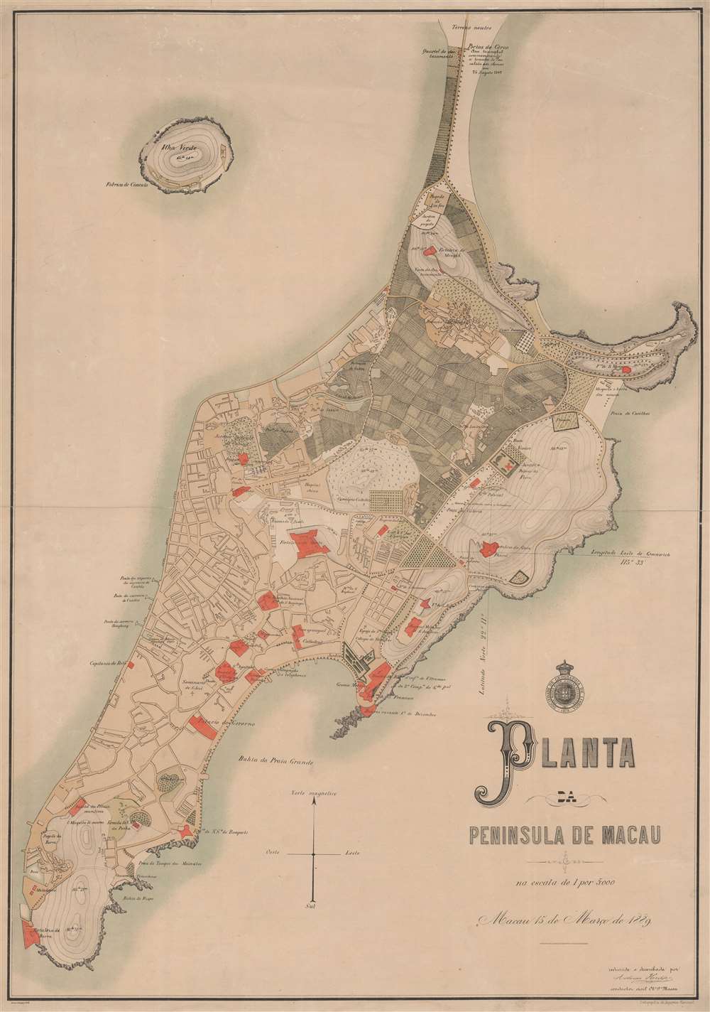
Planta de Peninsula de Macau.
1889 (dated) 24.5 x 32.5 in (62.23 x 82.55 cm) 1 : 5000
1889 (dated) 24.5 x 32.5 in (62.23 x 82.55 cm) 1 : 5000
Description
A rare 1889 large-scale chromolithograph map of Macau, China, by António Heitor and the Sociedade de Geografia de Lisboa. This map follows the 1887 Sino-Portuguese Treaty, considered one of the Unequal Treaties following the Opium Wars, which granted the Portuguese full sovereignty over Macau. The map can be divided into two sections, the Chinese community and village in the northeastern quadrant, here colored grey and full of farm fields, and the Portuguese urbanization encroaching from the south. Episcopal buildings, fortifications, and civil institutions are highlighted in red.
Chromolithography
Chromolithography, sometimes called oleography, is a color lithographic technique developed in the mid-19th century. The process involved using multiple lithographic stones, one for each color, to yield a rich composite effect. Oftentimes, the process would start with a black basecoat upon which subsequent colors were layered. Some chromolithographs used thirty or more separate lithographic stones to achieve the desired product. Chromolithograph color could also be effectively blended for even more dramatic results. The process became extremely popular in the late 19th and early 20th centuries when it emerged as the dominant method of color printing. The vivid color chromolithography produced made it exceptionally effective for advertising and propaganda imagery.Publication History and Census
The map was issued in 1889 by the Sociedade de Geografia de Lisboa and compiled by António Heitor. We note three examples in OCLC, as well as examples at the Biblioteca Nacional de Portugal, National Library of Australia, and Bibliothèque nationale de France. It was printed by Lithographia da Imprensa Nacional. We see no history of this map on the market.Cartographer
António Heitor (18?? - 18??) was a Portuguese surveyor, engineer, and public servant active in Asia in the late 19th century. Heitor was the Secção de Obras Pública in Timor, where he led the survey to delimitate the border with Dutch Timor. He was also active in Macau. There is another of the same name that we find in Brazil, although it is unclear if they are related. More by this mapmaker...
Condition
Good. Thin paper exhibits several edge repairs on verso. Upper margin extended. Centerfold reinforcement.
References
OCLC 51292804. Library of Congress G7823.M2 1889 .S6 TIL. National Library of Australia, MAP RM 278.