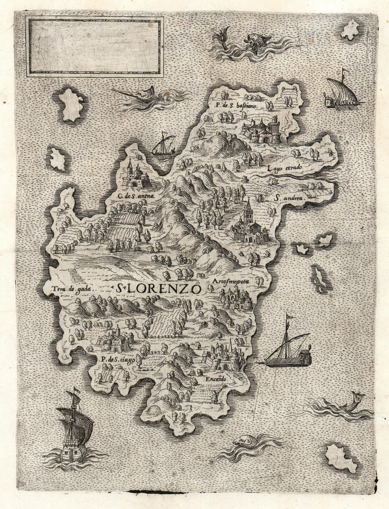
1570 Antonio Lafreri Rare Map of Madagascar
Madagascar-lafreri-1570$4,000.00

Title
S. Lorenzo.
1570 (undated) 10.25 x 7.75 in (26.035 x 19.685 cm) 1 : 6500000
1570 (undated) 10.25 x 7.75 in (26.035 x 19.685 cm) 1 : 6500000
Description
This is a beautifully engraved and evocative 1570 map of Madagascar (scar San Lorenzo) attributed to Antonio Lafreri. The map is enigmatic, presenting an alternative view of Madagascar at odds with the established cartographic canon. The blank cartouche, moreover, suggests incompleteness or possibly a proof, though admittedly no later states are known. The existence of this map underscores the significance of Madagascar as a stop on voyages to Asia - it is one of the few regional Lafreri maps depicting a location other than Europe.
It is not at all clear what informed Lafreri in this composition. Portuguese and French efforts to establish trading posts in Madagascar had, up to that point, met with resistance from the indigenous Malagasy people and their Arab trading partners. (Jean and Raoul Parmentier, who in 1529 stopped there en route to Sumatra, stayed just over a week before deciding that the two of their crew killed was too high a price to maintain a post.) The predominant mapping of Madagascar of the 16th century derived from Giacomo Gastaldi's 1564 8-sheet map of Africa. Bertelli's c. 1567 Isola de Zan Lorenzo is itself a strict copy of Madagascar as it appeared on Gastaldi's general Africa. There is some congruity between the placenames on Gastaldi's map and those on Cabot's 1544 world map, suggesting a common source for both. According to Betz, Gastaldi's Madagascar was derived from Portuguese reports, particularly that of Diogo Dias, who sighted the island in 1500. Gastaldi's mapping of Madagascar derives from nautical charts: barring pictorial mountains and a note regarding the presence of sandalwood, the detail is entirely coastal.
The present map diverges sharply from the 1564 Africa Gastaldi model: the pattern of rivers, mountains, and toponymy is absent here. The place names derive from earlier Gastaldi 1546 and c. 1550 world maps. Here, the similarities end. The shape of the island presented here bears no resemblance to any of Gastaldi's mappings of Madagascar. Where Gastaldi's map suggests a familiarity with the Portuguese charting of the island, Lafreri's map presents an alternative view, possibly derived from a purely narrative report. The map's presentation of cities, fields, and mountains suggests knowledge of the interior; thus not a nautical chart, but the puzzle lies in determining what report that might have been.
A Closer Look
The Madagascar portrayed is mountainous and forested, but also rich with cultivated fields, indicating a settled place. Six named towns are pictured in the style of European walled cities. The ocean is busy; a galleon approaches from the south while three Moorish rowing galleys patrol the north, east, and west. Four sea monsters also prowl the surrounding waters.It is not at all clear what informed Lafreri in this composition. Portuguese and French efforts to establish trading posts in Madagascar had, up to that point, met with resistance from the indigenous Malagasy people and their Arab trading partners. (Jean and Raoul Parmentier, who in 1529 stopped there en route to Sumatra, stayed just over a week before deciding that the two of their crew killed was too high a price to maintain a post.) The predominant mapping of Madagascar of the 16th century derived from Giacomo Gastaldi's 1564 8-sheet map of Africa. Bertelli's c. 1567 Isola de Zan Lorenzo is itself a strict copy of Madagascar as it appeared on Gastaldi's general Africa. There is some congruity between the placenames on Gastaldi's map and those on Cabot's 1544 world map, suggesting a common source for both. According to Betz, Gastaldi's Madagascar was derived from Portuguese reports, particularly that of Diogo Dias, who sighted the island in 1500. Gastaldi's mapping of Madagascar derives from nautical charts: barring pictorial mountains and a note regarding the presence of sandalwood, the detail is entirely coastal.
The present map diverges sharply from the 1564 Africa Gastaldi model: the pattern of rivers, mountains, and toponymy is absent here. The place names derive from earlier Gastaldi 1546 and c. 1550 world maps. Here, the similarities end. The shape of the island presented here bears no resemblance to any of Gastaldi's mappings of Madagascar. Where Gastaldi's map suggests a familiarity with the Portuguese charting of the island, Lafreri's map presents an alternative view, possibly derived from a purely narrative report. The map's presentation of cities, fields, and mountains suggests knowledge of the interior; thus not a nautical chart, but the puzzle lies in determining what report that might have been.
A Possible Precursor
Scholar Stefano Bifolco notes a similar work, also anonymous. That map (simpler, but with geographic detail broadly the same as the present work) has been attributed to Fernando Bertelli and given a date of 1556 by Borroni Salvadori. Bifolco confesses that it is not possible to determine whether either of these two maps is the source for the other, or whether they both draw on an independent, unknown source.Publication History and Census
This map is anonymous and cannot be dated with precision, though Bifolco attributes it to Antonio Lafreri based on its stylistic elements, and dates it 1570 on the strength of Lafreri's publishing catalog. His census notes 16 examples in institutional collections. Dates for examples in institutional collections vary wildly. We are aware of only two examples of this map to have appeared on the market within the past 40 years.Cartographer
Antonio Lafreri (1512–1577), born Antoine du Pérac Lafréry, was a Burgundian engraver, cartographer and publisher active in Rome in the 16th century. Apart from his birth in Orgelet in Burgundy, nothing is known about his early life, education or training. He is thought to have arrived in Rome by 1540 and was established as an engraver and printmaker in 1544. He became a business partner with Antonio Salamanca the Elder in 1553, until his partner's death in 1562. He would continue in the trade as a successful publisher of maps in the 1560s, and by 1570 he was selling made-to-order atlases both of his own maps and those of his collaborators. By the time of his death he was the leading dealer of engravings in Rome. His work was instrumental in disseminating the geographical ideas of Giacomo Gastaldi, but his battle scenes and maps focusing on the wars between Venice and the Ottoman Empire (particularly the famous Siege of Malta) are particularly prized. He is also noted for his Speculum Romanae Magnificentiae, a three volume collection of engravings of Rome produced over the course of the latter part of Lafreri's career, from 1545 to 1577. Other mapmakers in Rome and Venice sharing both Lafreri's aesthetic and geographical sources such as other Battista Agnese, Antonio Salamanca, Francesco Camocio the Younger, Donato Bertelli, Ferando Bertelli and Paolo Forlani are collectively generally referred to as belonging to the 'Lafreri' school of mapmakers, although this was not a formal organization. The terms 'Lafreri Atlases' and 'IATO (Italian, Assembled To Order) Atlases' are used to refer to the same class of works. He died at Rome in 1577. More by this mapmaker...
Condition
Excellent. Some marginal mends away from printed image, else a fine, untrimmed example.
References
OCLC 957502906 (dated 1555).