This item has been sold, but you can get on the Waitlist to be notified if another example becomes available, or purchase a digital scan.
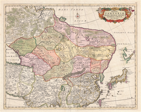
1680 De Wit Map of Central and Northeastern Asia: China, Tartary, Korea, Japan
MagnaTartariae-dewit-1680$350.00

Title
Magnae Tartariae Magni Mogolis Imperii Iaponiae et Chinae Nova Descriptio
1680 (undated) 17 x 22 in (43.18 x 55.88 cm) 1 : 14200000
1680 (undated) 17 x 22 in (43.18 x 55.88 cm) 1 : 14200000
Description
A beautiful example of Frederick de Wit's c. 1680 map of Tartary. The map covers from just north of the Arctic Circle to Formosa south to the the Bay of Bengal and Formosa, and from the Caspian Sea to Hokkaido or Yedso. Although parts of China, Japan, and northern India were somewhat mapped, most of northeastern Asia was fully unknown to western cartographers. The continent has here been given a curious rounded form that may be suggestive of a northeasterly route to Asia. Both the Great Wall of China and the Gobi Desert are clearly delineated. At the western edge of the map the overlarge Caspain Sea is erroneously mapped on an east-west rather than north-south axis.
Japan and Hokkaido (Yedso) are mapped according to the 1643 discoveries of Dutchmen Maerten de Vries and Cornelis Jansz Coen. Vries and Coen were in search of gold and silver isladns supposedly discovered early by a mysterious Spanish or Portuguese navigator, Juan de Gama. They sailed up the east coast of Japan and continued northward into the bay separating Honshū from Hokkaido. They skirted the east coast of this bay before discovering Kunashir, here Staten Land, the most westerly of the Japanese Kuril Island. They also sighted Iturup or Etorofu, the second Kuril Island. This island they only tenuously explored and named Compagnie, after the VOC, their sponsors. Subsequent maps assigned great mass to Compagnie on little more than speculation. These islands were not more properly mapped until the explorations of Vitus Behring.
The apocryphal Lake of Chiamay appears just north of the Bay of Bengal as the source of four important Southeast Asian river systems including the Irrawaddy, the Dharla, the Chao Phraya, and the Brahmaputra. The curious Lake of Chiamay (also called Chiam-may or Chian-may), roughly located in the area of Assam but sometimes as far north as Tibet and China, began to appear in maps of this region as early as the 16th century and persisted well into the mid 18th century. Its origins are unknown but may originate in a lost 16th century geography prepared by the Portuguese scholar Jao de Barros. It was speculated to be the source of five important Southeast Asian River systems and was mentioned in the journals of Sven Hedin. There are even records that the King of Siam led an invasionary force to take control of the lake in the 16th century. Nonetheless, the theory of Lake Chiamay was ultimately disproved and it disappeared from maps entirely by the 1760s.
This map was published both independently and as part of various complied and composite atlases.
Cartographer
Frederik de Wit (1629 - 1706) was a Dutch Golden Age cartographer active in the second half of the 17th and the early 18th centuries. De Wit was born of middle class Protestant stock in the western Netherlandish town of Gouda. He relocated to Amsterdam sometime before 1648, where he worked under Willem Blaeu. His first attributed engraved map, a plan of Haarlem for Antonius Sanderus' Flandria Illustrata, was issued around this time. He struck out on his own in 1654. The first chart that De Wit personally both drew and engraved was most likely his 1659 map of Denmark, REGNI DANIÆ Accuratissima delineatio Perfeckte Kaerte van ‘t CONJNCKRYCK DENEMARCKEN. His great wall map of the world and most famous work, Nova Totius Terrarum Orbis Tabula appeared one year later. Following the publication of his wall map De Wit quickly rose in prominence as a both cartographer and engraver. He married Maria van der Way in 1661 and through her became a citizen of Amsterdam in 1662. Around this time he also published his first major atlas, a composite production ranging in size from 17 to over 150 maps and charts. Other atlases and individual maps followed. In 1689 De Wit was granted a 15 year Privilege by the Dutch States General. (An early copyright that protected the recipient's rights to print and publish.) He was recognized with the honorific 'Good Citizen' in 1694. De Wit died in 1706 after which his wife Maria continued publishing his maps until about 1710. De Wit's son, Franciscus, had no interest in the map trade, instead choosing to prosper as a stockfish merchant. On her own retirement, Maria sold most De Wit maps and plates at a public auction. Most were acquired by Pieter Mortier and laid the groundwork for the 1721 rise of Covens and Mortier, the largest Dutch cartographic publishing house of the 18th century. More by this mapmaker...
Condition
Very good condition. Original centerfold. Original platemark visible. Blank on verso.
References
OCLC 315214302.