This item has been sold, but you can get on the Waitlist to be notified if another example becomes available, or purchase a digital scan.
1935 Linscott Pictorial Map of Maine
Maine-linscott-1935-2$62.50

Title
Maine Its Recreation and History.
1935 (dated) 27.25 x 19.25 in (69.215 x 48.895 cm) 1 : 765000
1935 (dated) 27.25 x 19.25 in (69.215 x 48.895 cm) 1 : 765000
Description
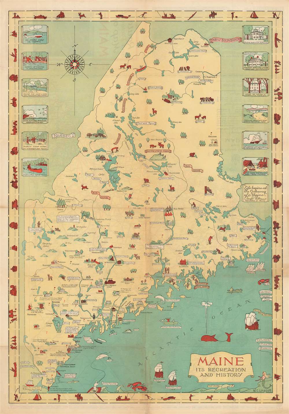
This is a 1935 Mellon C. Linscott pictorial map of Maine. Charmingly illustrated and attractively colored, Linscott's map traces Maine's history, promotes its industries, and highlights the many recreational opportunities afforded to locals and visitors alike. Maine's frontier past is placed at the forefront, with numerous forts illustrated throughout the state, including Fort William Henry, Fort Halifax, and Fort Western. Both Champlain and Captain John Smith's voyages are references, and sites visited by Champlain are noted. Birthplaces of luminaries that hail from Maine are also marked, including Henry Wadsworth Longfellow and Harriet Beecher Stowe. Colleges and universities are illustrated throughout the state, as are other famous buildings.
Maine: A Nature Lover's Paradise
Towns throughout the map are labeled, including Augusta and Portland. Maine's rich natural resources are certainly promoted by Linscott's work, most notably Acadia National Park on Mount Desert Island. People are seen hiking, golfing, and horseback riding on the island. Also of note is the promotion of the logging and paper industries, which must have played a critical role in Maine's economy. Wildlife, such as bears, foxes, bobcats, and deer, are illustrated throughout, some of which are being stalked by hunters shown in bright orange coats and hats. Anglers are active in most of Maine's lakes, and Linscott highlights the plethora of fish species available to anglers in Maine's lakes and off its coast. Vignettes along the upper portion of the left border illustrate several of the outdoor activities practiced by people in the state, while those along the right border present views of famous locations throughout Maine, including the homes of Harriet Beecher Stowe and Henry Wadsworth Longfellow, and a view of Cadillac Mountain Road in Acadia National Park.Publication History and Census
This map was created by Mellon C. Linscott and published by the State Highway Commission in 1935. Five examples are cataloged in OCLC and are part of the institutional collections at the Osher Map Library at the University of Southern Maine, the Buffalo and Erie County Public Library, the Maine State Library, the University of Illinois at Urbana Champaign, and the University of California Los Angeles.Cartographer
Mellon C. Linscott (fl. c. 1930 - 1970) was an American artist and engineer who lived and worked in Maine and New Hampshire. He was commissioned by the state of Maine and various municipalities in the 1930s to create maps of these areas. He included artistic views of local landmarks and recreational activities along with the standard elements found on maps. He also created a few specially commissioned maps for individual families. Today, Linscott's grandson operates a business named Linscott Maps that follows in Linscott's footsteps: creating custom-made maps for private clients. More by this mapmaker...
Condition
Very good. Light wear along original fold lines. Old repaired tear extending one and one half (1.5) inches into printed area evident on verso. Highway map of Maine on verso.
References
OCLC 13787486.