This item has been sold, but you can get on the Waitlist to be notified if another example becomes available, or purchase a digital scan.
1761 Antonio Bova Map of Malta and Gozo
MaltaGozo-bova-1761$1,200.00

Title
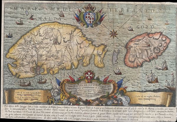
Pianta Geografia delle Isole di Malta, e Gozo della Sagra Religione Gerosolimitana di S. Giovanni delineata, ed incisa in quest anno 1761.
1761 (dated) 11.5 x 17.25 in (29.21 x 43.815 cm) 1 : 177000
1761 (dated) 11.5 x 17.25 in (29.21 x 43.815 cm) 1 : 177000
Description
A scarce 1761 map of Malta and Gozo by the Italian engraver Antonio Bova. Oriented to the southwest, this map covers all of Malta and Gozo as well as the interstitial island of Comino. Engraved in Palermo, Italy, Bova's map offers a highly decorative presentation with multiple sailing ships and elaborate armorial decorations in the cartouche work. A textual description of the islands are presented at the bottom of the map. Malta was the home of the Order of St John, or Knights Hospitaller, a crusading militant order that flourished in the middle ages until the 19th century. The order still exists and is today dedicated to humanitarian interests.
Cartographer
Antonio Bova (1688 - 1775), who was active as a priest and engraver in Palermo c. 1727-1773. He produced cartographic engravings, scenery, portraits and holy iconography. His devotional prints are usually signed only by his surname. More by this mapmaker...
Condition
Average. Backed on archiva tissued to repair closed tears. Some soiling.