1950 Ciqheri Pictorial Map of Malta, Gozo, and Comino
MalteseIslands-ciqheri-1950$500.00

Title
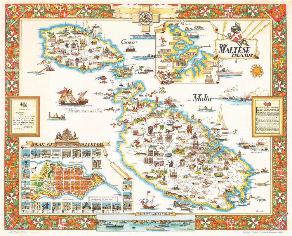
The Maltese Islands.
1950 (undated) 21.25 x 26 in (53.975 x 66.04 cm)
1950 (undated) 21.25 x 26 in (53.975 x 66.04 cm)
Description
This is a superb c. 1950 Aldo Ciqheri pictorial map of Malta, Gozo, and Comino, collectively known as the Maltese Islands. The map combines many of the elements that made Malta a Mediterranean tourist haven during the postwar era with many references to the archipelago's extraordinary history. Vignettes highlight tourist activities, including sunbathing, water polo, spearfishing, and waterskiing, while also promoting Malta's historic architecture and traditional lifestyles. An inset of a city plan of Valetta is situated in the lower left corner framed by twenty-six views of buildings and monuments, each of which is numerically associated. This inset is accompanied by a second, which illustrates the Valletta vicinity. Some details that harken back to Malta's past, under the Order of St. John or Knights Hospitaller, include a suit of armor above the title cartouche and the armorial crests in the border. Two proclamations, situated across from each other on the left and right sides, focus on the crucial role Malta played during World War II. The one on the right, on Buckingham Palace stationary and dated April 15, 1942, is a reproduction of the King George VI's declaration awarding Malta the George Cross for its 'heroism and devotion'. The other is a proclamation from Franklin D. Roosevelt saluting Malta in the name of the people of the United States, for their valorous service in defense of the 'cause of freedom and justice and decency throughout the world'.
Publication History
This map was drawn by Aldo Ciqheri and published by the Malta Tourism Bureau c. 1950.Cartographer
Aldo Ciqheri (19?? - 19??) was an Italian artist and illustrator active during the mid-20th century. More by this mapmaker...
Condition
Very good. Even overall toning. Light wear along margins. Blank on verso.