1945 Cleartype American Map Co. Folding Map of Manhattan
Manhattan-cleartype-1945$300.00


Title
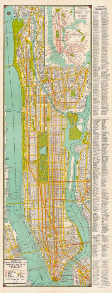
Cleartype street, house number, and transportation map of Manhattan (New York County, N.Y.).
1945 (undated) 48.5 x 15.25 in (123.19 x 38.735 cm) 1 : 18000
1945 (undated) 48.5 x 15.25 in (123.19 x 38.735 cm) 1 : 18000
Description
A large and detailed c. 1945 indexed folding map of Manhattan, produced by Cleartype Maps and the American Map Company. It provides fantastic detail on the layout, transportation, and attractions of Manhattan at the start of the postwar era.
Although ferries and steamship lines are meticulously noted, the city was shifting decidedly towards unground subways and automobiles as the primary means of transportation, including interborough and interstate travel. The city's subways and elevated trains were themselves transforming rapidly, as subway lines moved towards consolidation, a process completed with the creation of the New York City Transit Authority in 1953. The Third Avenue Elevated Line shown here was the last of what had been five elevated trains running up Manhattan's avenues, which were phased out as the quieter and cleaner subway lines were built and opened in succession. Meanwhile, the Lincoln, Holland, and Queens Midtown Tunnels, along with the George Washington and Triborough Bridges, had all opened in the preceding fifteen years, joining earlier bridges in connecting the city's boroughs and the city with New Jersey.
A Closer Look
Coverage includes all of Manhattan, several East River islands, and portions of the Bronx, Queens, Brooklyn, and New Jersey. An attractive alphanumeric grid noted in the border surrounds the map, corresponding to an index at right listing streets, points of interest, and practical information, such as railroad and bus terminals. The map is especially detailed in listing the numbers and operators of piers on Manhattan.Although ferries and steamship lines are meticulously noted, the city was shifting decidedly towards unground subways and automobiles as the primary means of transportation, including interborough and interstate travel. The city's subways and elevated trains were themselves transforming rapidly, as subway lines moved towards consolidation, a process completed with the creation of the New York City Transit Authority in 1953. The Third Avenue Elevated Line shown here was the last of what had been five elevated trains running up Manhattan's avenues, which were phased out as the quieter and cleaner subway lines were built and opened in succession. Meanwhile, the Lincoln, Holland, and Queens Midtown Tunnels, along with the George Washington and Triborough Bridges, had all opened in the preceding fifteen years, joining earlier bridges in connecting the city's boroughs and the city with New Jersey.
Publication History and Census
This map was produced by Cleartype Maps, a subsidiary of the American Map Company, around the year 1945. Though undated, the map must have been published after 1942, as the Third Ave. line is the only elevated line present in Manhattan here. At the same time, the Brooklyn-Battery Tunnel is noted as 'under construction,' indicating a date before 1950. The presence of the Stuyvesant Town-Peter Cooper Village housing complex (opened 1947) suggests a somewhat later date in that range, though the project was under planning and construction for several years beginning during World War II. This map is listed among the holdings of Harvard University, Stanford University, and Cornell University, while an earlier edition dated 1942 (OCLC 869358273) is held by Stanford.Cartographer
Cleartype Maps (c. 1929 – 1993) was a map publisher based in New York that was a subsidiary of the American Map Company (c. 1910 – 2013). It principally produced maps of cities and states in the U.S., but also made maps of Canada and Mexico and occasionally world maps and maps of other parts of the world. More by this mapmaker...
Condition
Very good. Light wear along original fold lines. Verso repairs to fold separations and at fold intersections. Two small areas of infill at fold intersections. Reinforced where previously attached to binder.
References
OCLC 4870762.