1945 U.S. Army Forces, Pacific City Plan or Map of Manila, Philippines
Manila-afpac-1945$500.00

Title
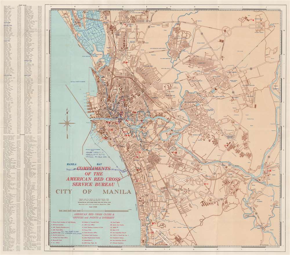
City of Manila. Compliments of the American Red Cross Service Bureau.
1945 (dated) 18.75 x 21.5 in (47.625 x 54.61 cm) 1 : 37000
1945 (dated) 18.75 x 21.5 in (47.625 x 54.61 cm) 1 : 37000
Description
This is a September 1945 U.S. Army Forces, Pacific (AFPAC) city plan or map of Manila, Philippines. Distributed by the American Red Cross Service Bureau, red overprinting marks twenty-seven locations around Manila, including two American Red Cross facilities, several canteens, a few clubs, and 'Y.M.C.A. Snack Bar No. 1'. All locations are identified in an index situated in the lower left. Districts within Manila are labeled in blue, along with rivers, lagoons, and locations around the city, including the University of the Philippines. Major streets are identified, but most smaller streets are only illustrated. Two indexes situated along the left border list streets and buildings in alphabetical order.
Manuscript Notations
Manuscript notations in blue ink appear in several places. Written by a soldier on his 'second liberty in Manila', a blue line traces his peregrinations. This person underlines several streets in the index that appear along this route. The only other comment is written in the red overprinted index in the lower left corner which states, 'got this map and had good lemonade with cookies' next to the underlined Manila Club.Publication History and Census
This map was created and printed by the 29th Engineer Base Topographic Battalion (who put themselves on the map - number 18 in the overprinted index!) in September 1945. It appears that at least two previous editions had been printed by AFPAC before the present edition. An OCLC reference exists for a map of the same title, although the only publication information date given is the first one printed on this map, 1 August 1945. The OCLC reference also states that thirteen libraries hold examples of seven different editions. Unfortunately, these have not been uniformly digitized so we are unable to say with any certainty how many examples of the September 1945 printing are referenced here.Condition
Very good. Exhibits wear along original fold lines. Manuscript ink notations by original owner on recto detailing his liberty in Manila after World War II.
References
OCLC 233824868.