This item has been sold, but you can get on the Waitlist to be notified if another example becomes available, or purchase a digital scan.
1744 Le Rouge Map of the World in Hemispheres
MappeMonde-lerouge-1744$2,500.00

Title
Mappe monde nouvelle : dediée a monseigneur le comte de Maurepas Ministre et Secretaire d'Etat.
1744 (dated) 21 x 29 in (53.34 x 73.66 cm) 1 : 70000000
1744 (dated) 21 x 29 in (53.34 x 73.66 cm) 1 : 70000000
Description
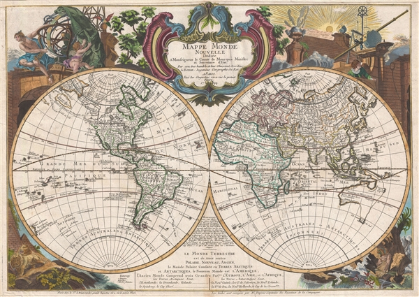
A fine example of Le Rouge's highly decorative 1744 / 48 map of the world on a stereographic projection or, more commonly, in two hemispheres. Cartographically the map appears on the cusp of the great explorations of the 18th century, and as such, offers much of speculative interest, particularly with regarding to the Arctic, the Pacific Northwest, Australia, and the South Seas or Antarctic. The map proper is surrounded by allegorical cartouche work focusing primarily on human achievement. It is noteworthy that this is the second state of Le Rouge's map, with the primary difference between the two states being his embrace of the De Fonte apocrypha in the present state, c. 1748.
This we will begin our survey of this map with what is arguably it is most interesting aspect, this being the curious treatment of the American Pacific Northwest and the Siberian Arctic. Here Le Rouge is attempting to integrate the factual Russian Siberia explorations in by Vitus Bering (1741) and Aleksei Ilyich Chirikov (Tchirikow, 1741), as well as, the inland Canadian explorations of Henry Kelsey (1691) and Pierre de la Verendrye (1731), with the supposed explorations of De Fonte and Bernarda.
The tale of De Fonte and Bernarda's discoveries in the American Northwest are particularly interesting. The De Fonte legend first appeared in a 1706 English publication entitled Memoirs of the Curious. This short-lived magazine published a previously unknown account by a supposed Spanish Admiral named Bartholomew de Fonte. De Fonte is said to have sailed up the Pacific coast of North America in 1640. On this voyage he apparently discovered a series of gigantic lakes, seas, and rivers heading eastward from the Pacific towards Hudson Bay. The De Fonte story relates how, on one of these great inland lakes, he met with a westward bound ship from Boston that must to have come through the Northwest Passage. At the same time De Fonte sent one of his sub-captains, Pedro Bernardo, northward to explore a 'beautiful river with deep calm waters.' This exploration led to the discoveries of Lake Valasco, R. Bernarda, and Lac Bernarda – seen here as a long fingerlike lake extending inland form the Pacific to Baffin Bay. Today, based upon inaccuracies and falsities, we know the entire De Fonte article to have been a fabrication, however, it set 18th century afire with speculation that a Northwest Passage must indeed exist. Even such luminaries as Benjamin Franklin wrote long defenses of De Fonte.
Le Rouge makes the novel decision to associate De Fonte's lake with Henry Kelsey's discovery and Pierre de la Verendrye's discovery of the Assiniboine River, Lake of the Woods, and Lake Winnepeg. By vastly exaggerating the proportions of these lakes, and vastly reducing the proportions of North American in general, the speculation seems appears, on this map at least, fully within reason.
The second part of this map that draws the eye is Le Rouge's ephemeral depiction of Nouvelle Hollande or Australia. Here the entire eastern part of Australia is only ghosted in, evidence of just how little was then known of this remote continent. Dutch discoveries by Van Diemen and others are noted, but little else is known. Terre du St. Espirit is the only 'definite' point on the east coast and references failed explorations by Alvaro de Mendaña de Neira (1595-1596) and Pedro Fernandez de Quiros (1605-1606). This is in fact a miss-mapping of the New Hebrides, but this fact would not be discovered until the islands were revisited by Captain Cook. For the remainder of eastern Australia, it is clear the much is speculative, with Tasmania and New Guinea being joined to the continental mainland.
Elsewhere on the map Hokkaido, generally noted as Yeso or Yeco, has finally taken on a clearly insular form, although it is joined to town forklike projections extending southwards from the Isle d'Amor. Amor is actually Sakhalin. The forks creating a bay on the eastern side of Yeso are in fact the southern fingers of Sakhalin. The great landmass to the east, Terre de la Compagnie, is in fact an over ambitious mapping of Etorofu, the second Kuril Island based upon the 1643 discoveries of Dutchmen Maerten de Vries and Cornelis Jansz Coen. Vries and Coen were in search of gold and silver islands supposedly discovered early by a mysterious Spanish or Portuguese navigator, Juan de Gama. They sailed up the east coast of Japan and continued northward into the bay separating Honshū from Hokkaido. They skirted the east coast of this bay before discovering Kunashir, here Staten Land, the most westerly of the Japanese Kuril Island. They also sighted Iturup or Etorofu, the second Kuril Island. This island they only tenuously explored and named Compagnie, after the VOC, their sponsors. Subsequent maps assigned great mass to Compagnie on little more than speculation. This mapping was not rectified until Cook.
This map also contains a number of other curious elements, including a maelstrom situated in the middle of the Atlantic Ocean. A few other 18th century maps identify this curious whirlpool and its earliest appears seems to be associated with the mappings of Guillaume Delisle, a studious cartographer who doubtless drew it from actual mariner's reports. Interestingly modern scientists have recently identified two massive whirlpools in the South Atlantic. While not permanent, these whirlpools are known last several months before dissipating. One can only wonder if Delisle discovered 18th century record of this only recently rediscovered phenomenon?
A note at the bottom of the mape notes that the East Indies were improved by reports from Captian 'Daprais.' This references the explorations of the French navigator Jean-Baptiste-Nicolas-Denis d'Apres de Mannevillette, who published his charts in 1743.
The map is dedicated to the Comte de Maurepas, then the French secretary or state and a great supporter of French cartography. It was published in the 1748 edition of the Atlas Generale.
Cartographer
Georges-Louis Le Rouge (c. 1707 - c. 1790) was a Paris based map publisher operating in the middle part of the 18th century. Le Rouge was born in Hanover Germany as Georg Ludwig, where he was educated and employed as a military engineer and surveyor. His father may have been the French architect Louis Remy de la Fosse (1659 - 1726), which would explain his early education in both engineering and draftsmanship. He assisted his father on a large-scale plan of Darmstadt, which he completed following his father's death in 1726. He may have remained in Darmstadt, but little is known of his life from 1726 - 1736, when he appears in Paris. Le Rouge acquired a position as military and civil engineer for King Louis XV and Louis XVI. Around this time, he Francophied his name to 'Le Rouge'. In 1840, he set up shop on the Rue Des Grands Augustins as an engraver, book publisher, and map publisher. He partnered with the English cartographer and engineer John Rocque (1709 - 1762), who became an important source for English maps, which Le Rouge re-engraved for French use. Despite being born German and adopting Paris as his home, Le Rouge was an ardent Anglophile and spent much of his time translating English books and maps into French. During his active period of roughly forty years Le Rouge produced thousands of maps and diagrams ranging from city and town plans, to atlases, plans of military campaigns and sea charts. He was a friend and correspondent of Benjamin Franklin (1706 - 1790), with whom he produced the important 1769 Franklin/Folger Map of the Gulf Stream. Franklin, who met Le Rouge in Paris, writes that 'He [Le Rouge] is, I believe, a proper person.' He was awarded for his diligence with the impressive but unstipended honorific 'Geographe du Roi'. They may not have served him swell during the French Revolution (1789 - 1799), as his last known work was published in 1789, just before the storming of the Bastille. The exact date of Le Rouge's death remains a mystery. By most estimates, he is believed to have been alive in 1790, but may have lived as long as 1794. More by this mapmaker...
Source
Le Rouge, George Louis, Atlas Generale (Paris) 1748.
Condition
Very good. Original centerfold. Upper margin extended. Original platemark visible. Blank on verso.
References
Oehme, R., 'A French World Atlas of the 18th Century: The Atlas General of G. L. Le Rouge,' Imago Mundi, vol 25 (1971), pp. 55-64. OCLC 558020222, 21805873.